Devils Hole Gulch Topo Map Colorado
To zoom in, hover over the map of Devils Hole Gulch
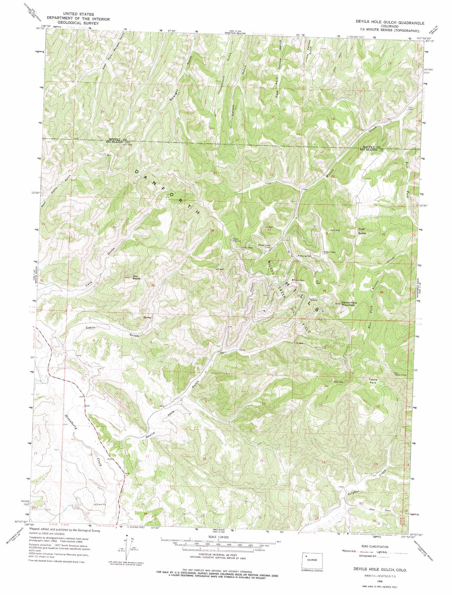
USGS Topo Quad 40107b8 - 1:24,000 scale
| Topo Map Name: | Devils Hole Gulch |
| USGS Topo Quad ID: | 40107b8 |
| Print Size: | ca. 21 1/4" wide x 27" high |
| Southeast Coordinates: | 40.125° N latitude / 107.875° W longitude |
| Map Center Coordinates: | 40.1875° N latitude / 107.9375° W longitude |
| U.S. State: | CO |
| Filename: | o40107b8.jpg |
| Download Map JPG Image: | Devils Hole Gulch topo map 1:24,000 scale |
| Map Type: | Topographic |
| Topo Series: | 7.5´ |
| Map Scale: | 1:24,000 |
| Source of Map Images: | United States Geological Survey (USGS) |
| Alternate Map Versions: |
Devils Hole Gulch CO 1966, updated 1969 Download PDF Buy paper map Devils Hole Gulch CO 1966, updated 1977 Download PDF Buy paper map Devils Hole Gulch CO 2010 Download PDF Buy paper map Devils Hole Gulch CO 2013 Download PDF Buy paper map Devils Hole Gulch CO 2016 Download PDF Buy paper map |
1:24,000 Topo Quads surrounding Devils Hole Gulch
Cedar Knob |
Juniper Mountain |
Juniper Hot Springs |
Horse Gulch |
Round Bottom |
Citadel Plateau |
Price Creek |
Easton Gulch |
Axial |
Monument Butte |
Indian Valley |
White Rock |
Devils Hole Gulch |
Ninemile Gap |
Thornburgh |
White River City |
Buckskin Point |
Meeker |
Rattlesnake Mesa |
Sawmill Mountain |
Greasewood Gulch |
Segar Mountain |
Lo 7 Hill |
Veatch Gulch |
Big Beaver Reservoir |
> Back to 40107a1 at 1:100,000 scale
> Back to 40106a1 at 1:250,000 scale
> Back to U.S. Topo Maps home
Devils Hole Gulch topo map: Gazetteer
Devils Hole Gulch: Flats
Tepee Park elevation 2480m 8136′Devils Hole Gulch: Oilfields
Wilson Creek Oil Field elevation 2348m 7703′Devils Hole Gulch: Reservoirs
Dads Reservoir elevation 2144m 7034′Devils Hole Gulch: Streams
East Fork Wilson Creek elevation 2175m 7135′Devils Hole Gulch: Summits
Coal Butte elevation 2581m 8467′Devils Hole Mountain elevation 2646m 8681′
Old Baldy elevation 2454m 8051′
Devils Hole Gulch: Valleys
Cabin Gulch elevation 2014m 6607′Devils Hole Gulch elevation 1977m 6486′
Devils Hole Gulch digital topo map on disk
Buy this Devils Hole Gulch topo map showing relief, roads, GPS coordinates and other geographical features, as a high-resolution digital map file on DVD: