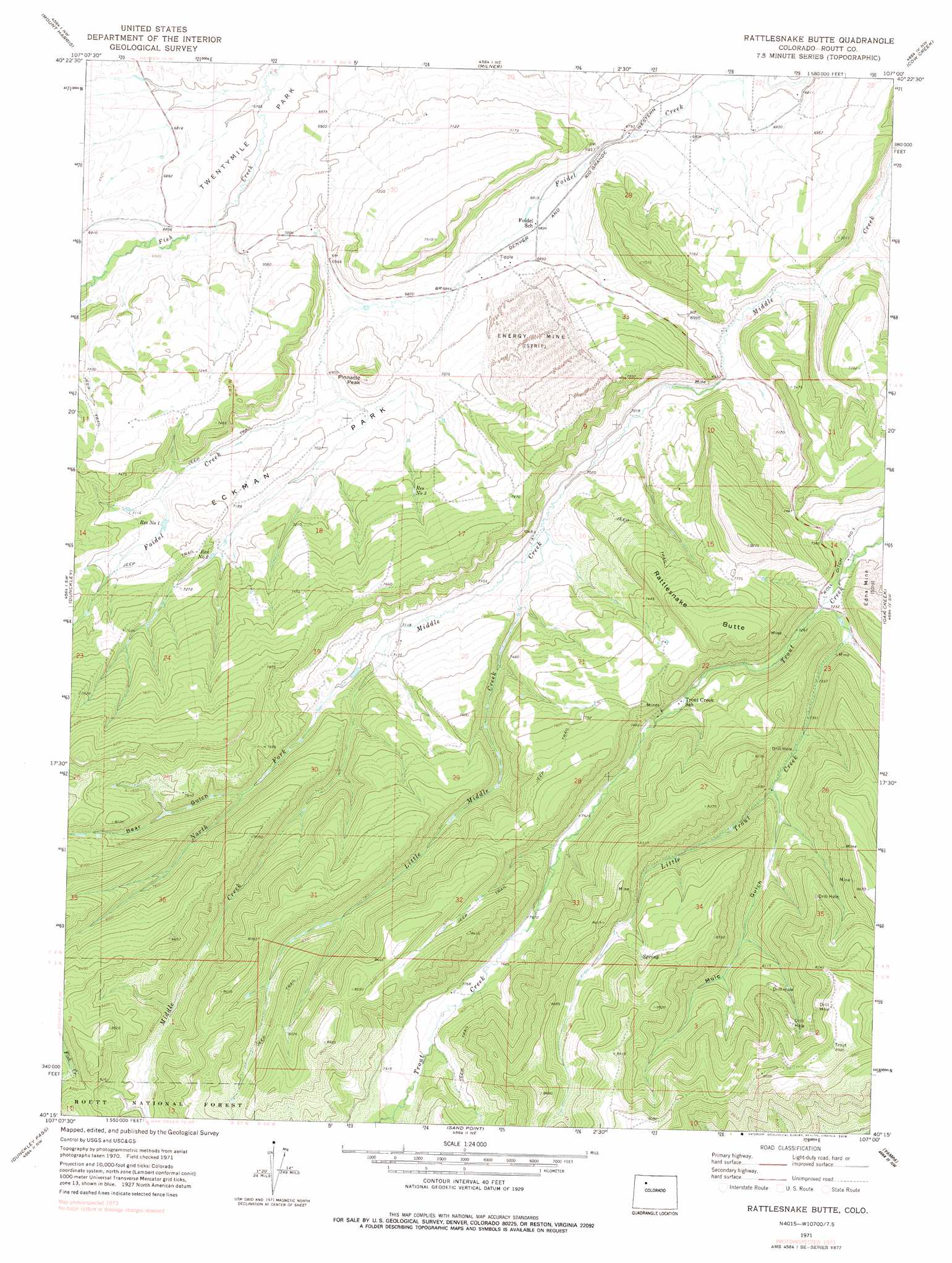
Rattlesnake Butte Topo Map Colorado
To zoom in, hover over the map of Rattlesnake Butte
USGS Topo Quad 40107c1 - 1:24,000 scale
| Topo Map Name: | Rattlesnake Butte |
| USGS Topo Quad ID: | 40107c1 |
| Print Size: | ca. 21 1/4" wide x 27" high |
| Southeast Coordinates: | 40.25° N latitude / 107° W longitude |
| Map Center Coordinates: | 40.3125° N latitude / 107.0625° W longitude |
| U.S. State: | CO |
| Filename: | o40107c1.jpg |
| Download Map JPG Image: | Rattlesnake Butte topo map 1:24,000 scale |
| Map Type: | Topographic |
| Topo Series: | 7.5´ |
| Map Scale: | 1:24,000 |
| Source of Map Images: | United States Geological Survey (USGS) |
| Alternate Map Versions: |
Rattlesnake Butte CO 1971, updated 1974 Download PDF Buy paper map Rattlesnake Butte CO 1971, updated 1978 Download PDF Buy paper map Rattlesnake Butte CO 2000, updated 2004 Download PDF Buy paper map Rattlesnake Butte CO 2011 Download PDF Buy paper map Rattlesnake Butte CO 2013 Download PDF Buy paper map Rattlesnake Butte CO 2016 Download PDF Buy paper map |
| FStopo: | US Forest Service topo Rattlesnake Butte is available: Download FStopo PDF Download FStopo TIF |
1:24,000 Topo Quads surrounding Rattlesnake Butte
Rock Spring Gulch |
Hooker Mountain |
Wolf Mountain |
Mad Creek |
Rocky Peak |
Hayden |
Mount Harris |
Milner |
Cow Creek |
Steamboat Springs |
Hayden Gulch |
Dunckley |
Rattlesnake Butte |
Oak Creek |
Blacktail Mountain |
Pagoda Peak |
Dunckley Pass |
Sand Point |
Yampa |
Green Ridge |
Ripple Creek |
Devils Causeway |
Orno Peak |
Trapper |
Toponas |
> Back to 40107a1 at 1:100,000 scale
> Back to 40106a1 at 1:250,000 scale
> Back to U.S. Topo Maps home
Rattlesnake Butte topo map: Gazetteer
Rattlesnake Butte: Dams
Eckman Park Number 1 Dam elevation 2158m 7080′Rattlesnake Butte: Flats
Eckman Park elevation 2152m 7060′Rattlesnake Butte: Mines
Apex Mine elevation 2343m 7687′Apex Number Two Mine elevation 2442m 8011′
Big Mack Mine elevation 2255m 7398′
Blue Spruce Mine elevation 2253m 7391′
Colo-Yamp Mine elevation 2245m 7365′
Energy Mine elevation 2196m 7204′
Foidel Creek Mine elevation 2133m 6998′
Johnnies Coal Mine elevation 2465m 8087′
Middle Creek Mine elevation 2138m 7014′
Rattlesnake Butte: Reservoirs
Eckman Park Reservoir Number 1 elevation 2158m 7080′Number One Reservoir elevation 2159m 7083′
Reservoir Number Three elevation 2204m 7230′
Reservoir Number Two elevation 2180m 7152′
Rattlesnake Butte: Streams
Little Middle Creek elevation 2141m 7024′Little Trout Creek elevation 2202m 7224′
North Fork Middle Creek elevation 2170m 7119′
Rattlesnake Butte: Summits
Pinnacle Peak elevation 2251m 7385′Rattlesnake Butte elevation 2393m 7851′
Rattlesnake Butte: Valleys
Bear Gulch elevation 2267m 7437′Mule Gulch elevation 2289m 7509′
Rattlesnake Butte digital topo map on disk
Buy this Rattlesnake Butte topo map showing relief, roads, GPS coordinates and other geographical features, as a high-resolution digital map file on DVD: