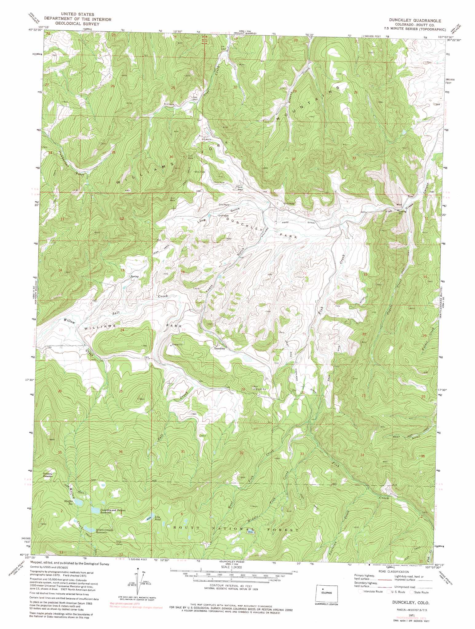
Dunckley Topo Map Colorado
To zoom in, hover over the map of Dunckley
USGS Topo Quad 40107c2 - 1:24,000 scale
| Topo Map Name: | Dunckley |
| USGS Topo Quad ID: | 40107c2 |
| Print Size: | ca. 21 1/4" wide x 27" high |
| Southeast Coordinates: | 40.25° N latitude / 107.125° W longitude |
| Map Center Coordinates: | 40.3125° N latitude / 107.1875° W longitude |
| U.S. State: | CO |
| Filename: | o40107c2.jpg |
| Download Map JPG Image: | Dunckley topo map 1:24,000 scale |
| Map Type: | Topographic |
| Topo Series: | 7.5´ |
| Map Scale: | 1:24,000 |
| Source of Map Images: | United States Geological Survey (USGS) |
| Alternate Map Versions: |
Dunckley CO 1971, updated 1974 Download PDF Buy paper map Dunckley CO 1971, updated 1974 Download PDF Buy paper map Dunckley CO 1971, updated 1980 Download PDF Buy paper map Dunckley CO 2000, updated 2004 Download PDF Buy paper map Dunckley CO 2011 Download PDF Buy paper map Dunckley CO 2013 Download PDF Buy paper map Dunckley CO 2016 Download PDF Buy paper map |
| FStopo: | US Forest Service topo Dunckley is available: Download FStopo PDF Download FStopo TIF |
1:24,000 Topo Quads surrounding Dunckley
Ralph White Lake |
Rock Spring Gulch |
Hooker Mountain |
Wolf Mountain |
Mad Creek |
Breeze Mountain |
Hayden |
Mount Harris |
Milner |
Cow Creek |
Pagoda |
Hayden Gulch |
Dunckley |
Rattlesnake Butte |
Oak Creek |
Slide Creek |
Pagoda Peak |
Dunckley Pass |
Sand Point |
Yampa |
Lost Park |
Ripple Creek |
Devils Causeway |
Orno Peak |
Trapper |
> Back to 40107a1 at 1:100,000 scale
> Back to 40106a1 at 1:250,000 scale
> Back to U.S. Topo Maps home
Dunckley topo map: Gazetteer
Dunckley: Canals
East Side Number 2 Ditch elevation 2270m 7447′West Side Highland Ditch elevation 2293m 7522′
Williams Park Ditch elevation 2155m 7070′
Dunckley: Dams
Dunkley Dubeau Dam elevation 2712m 8897′James Yoast Marion Dam elevation 2349m 7706′
Seaton Dam elevation 2626m 8615′
Sellers-Crowell Dam elevation 2738m 8982′
Shaffer Dam elevation 2689m 8822′
Yoast Dam elevation 2211m 7253′
Dunckley: Flats
Dubeau Meadow elevation 2689m 8822′Dunckley Park elevation 2155m 7070′
Williams Park elevation 2302m 7552′
Dunckley: Mines
Pinnacle Mine elevation 2519m 8264′Dunckley: Populated Places
Dunckley elevation 2318m 7604′Dunckley: Reservoirs
Dunckley and Dubeau Reservoir elevation 2712m 8897′Dunkley Dubeau Reservoir elevation 2712m 8897′
James Marion Yoast Reservoir elevation 2349m 7706′
Lily Pond elevation 2756m 9041′
Sellers - Crowell Reservoir elevation 2738m 8982′
Sellers-Crowell Reservoir elevation 2738m 8982′
Shaffer Reservoir elevation 2690m 8825′
Yoast Reservoir Number 1 elevation 2211m 7253′
Dunckley: Streams
Austrian Creek elevation 2376m 7795′Coyote Creek elevation 2110m 6922′
Middle Fish Creek elevation 2303m 7555′
Salt Creek elevation 2214m 7263′
West Fish Creek elevation 2278m 7473′
Dunckley: Valleys
Fish Creek Canyon elevation 2094m 6870′Long Gulch elevation 2169m 7116′
Yoast Gulch elevation 2157m 7076′
Dunckley digital topo map on disk
Buy this Dunckley topo map showing relief, roads, GPS coordinates and other geographical features, as a high-resolution digital map file on DVD: