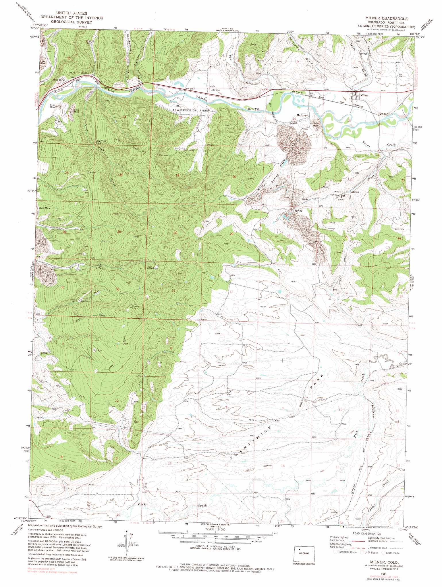
Milner Topo Map Colorado
To zoom in, hover over the map of Milner
USGS Topo Quad 40107d1 - 1:24,000 scale
| Topo Map Name: | Milner |
| USGS Topo Quad ID: | 40107d1 |
| Print Size: | ca. 21 1/4" wide x 27" high |
| Southeast Coordinates: | 40.375° N latitude / 107° W longitude |
| Map Center Coordinates: | 40.4375° N latitude / 107.0625° W longitude |
| U.S. State: | CO |
| Filename: | o40107d1.jpg |
| Download Map JPG Image: | Milner topo map 1:24,000 scale |
| Map Type: | Topographic |
| Topo Series: | 7.5´ |
| Map Scale: | 1:24,000 |
| Source of Map Images: | United States Geological Survey (USGS) |
| Alternate Map Versions: |
Milner CO 1971, updated 1974 Download PDF Buy paper map Milner CO 1971, updated 1974 Download PDF Buy paper map Milner CO 1971, updated 1980 Download PDF Buy paper map Milner CO 2010 Download PDF Buy paper map Milner CO 2013 Download PDF Buy paper map Milner CO 2016 Download PDF Buy paper map |
1:24,000 Topo Quads surrounding Milner
Slide Mountain |
Quaker Mountain |
Pilot Knob |
Clark |
Floyd Peak |
Rock Spring Gulch |
Hooker Mountain |
Wolf Mountain |
Mad Creek |
Rocky Peak |
Hayden |
Mount Harris |
Milner |
Cow Creek |
Steamboat Springs |
Hayden Gulch |
Dunckley |
Rattlesnake Butte |
Oak Creek |
Blacktail Mountain |
Pagoda Peak |
Dunckley Pass |
Sand Point |
Yampa |
Green Ridge |
> Back to 40107a1 at 1:100,000 scale
> Back to 40106a1 at 1:250,000 scale
> Back to U.S. Topo Maps home
Milner topo map: Gazetteer
Milner: Dams
Fish Creek Dam elevation 2051m 6729′Milner: Flats
Twentymile Park elevation 2052m 6732′Milner: Mines
Bear River Mine elevation 2130m 6988′Blazer Mine elevation 1994m 6541′
Curtis Mine elevation 2048m 6719′
Elk Creek Mine elevation 2041m 6696′
International Mine elevation 2016m 6614′
McGregor Mine elevation 2092m 6863′
Meadows Number One Mine elevation 1990m 6528′
Rustic Coal Mine elevation 2085m 6840′
Seneca Strip Mine elevation 2269m 7444′
Trout Creek Number One Mine elevation 1990m 6528′
Twenty Mile Mine elevation 2049m 6722′
Milner: Oilfields
Tow Creek Oil Field elevation 1976m 6482′Milner: Populated Places
Bear River (historical) elevation 1958m 6423′McGregor elevation 1982m 6502′
Milner elevation 1988m 6522′
Milner: Reservoirs
Fish Creek Reservoir elevation 2051m 6729′Milner: Streams
Cheney Creek elevation 1976m 6482′Elk Creek elevation 1976m 6482′
Milner Spring Creek elevation 2021m 6630′
Tow Creek elevation 1971m 6466′
Trout Creek elevation 1971m 6466′
Milner: Valleys
Butcherknife Gulch elevation 1970m 6463′Coal View Gulch elevation 1961m 6433′
Little Butcherknife Gulch elevation 1975m 6479′
Little Cheney Gulch elevation 2000m 6561′
McCrosky Gulch elevation 1986m 6515′
Milner digital topo map on disk
Buy this Milner topo map showing relief, roads, GPS coordinates and other geographical features, as a high-resolution digital map file on DVD: