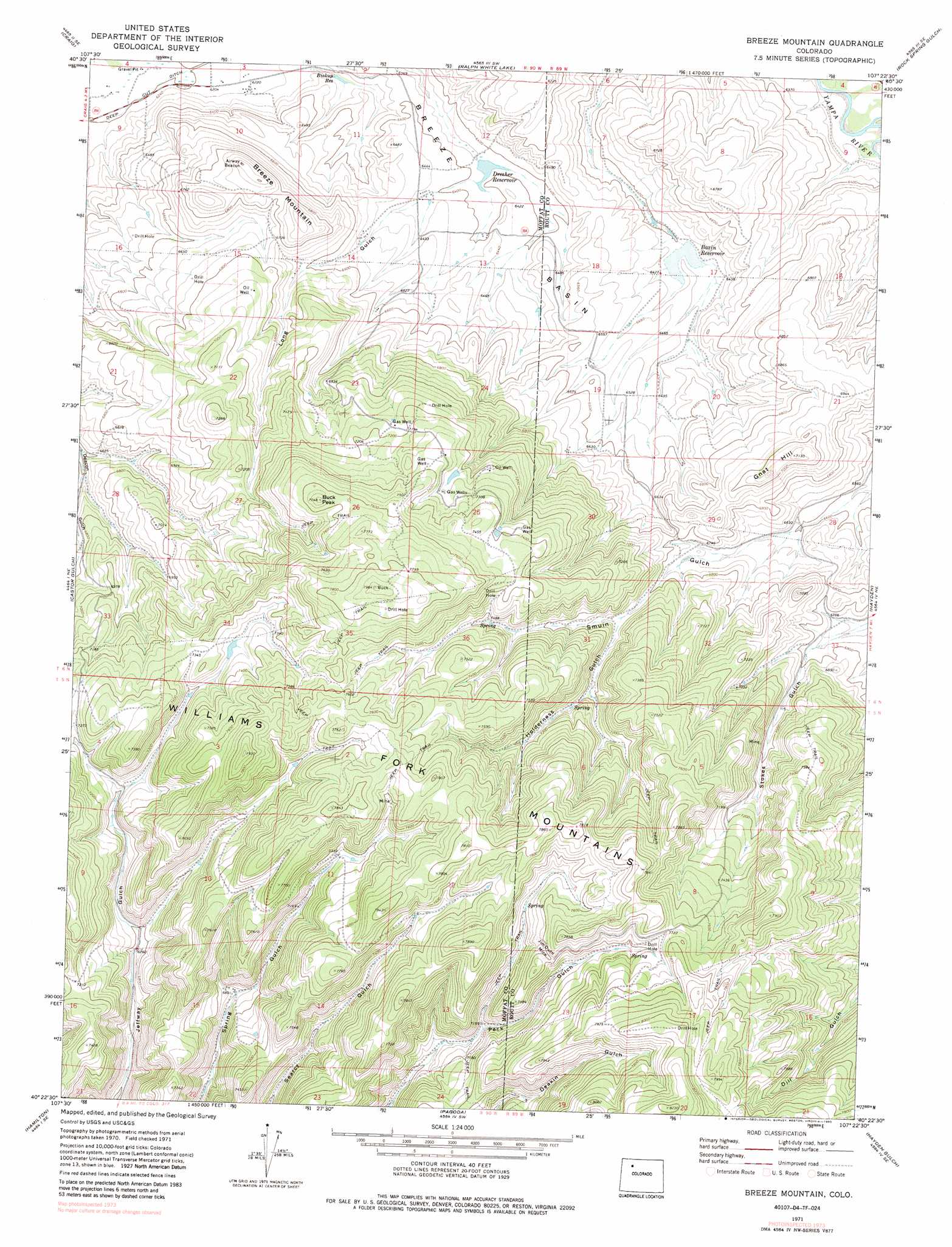
Breeze Mountain Topo Map Colorado
To zoom in, hover over the map of Breeze Mountain
USGS Topo Quad 40107d4 - 1:24,000 scale
| Topo Map Name: | Breeze Mountain |
| USGS Topo Quad ID: | 40107d4 |
| Print Size: | ca. 21 1/4" wide x 27" high |
| Southeast Coordinates: | 40.375° N latitude / 107.375° W longitude |
| Map Center Coordinates: | 40.4375° N latitude / 107.4375° W longitude |
| U.S. State: | CO |
| Filename: | o40107d4.jpg |
| Download Map JPG Image: | Breeze Mountain topo map 1:24,000 scale |
| Map Type: | Topographic |
| Topo Series: | 7.5´ |
| Map Scale: | 1:24,000 |
| Source of Map Images: | United States Geological Survey (USGS) |
| Alternate Map Versions: |
Breeze Mountain CO 1971, updated 1974 Download PDF Buy paper map Breeze Mountain CO 1971, updated 1974 Download PDF Buy paper map Breeze Mountain CO 1971, updated 1985 Download PDF Buy paper map Breeze Mountain CO 2010 Download PDF Buy paper map Breeze Mountain CO 2013 Download PDF Buy paper map Breeze Mountain CO 2016 Download PDF Buy paper map |
1:24,000 Topo Quads surrounding Breeze Mountain
Craig Nw |
Craig Ne |
Mcinturf Mesa |
Slide Mountain |
Quaker Mountain |
Pine Ridge |
Craig |
Ralph White Lake |
Rock Spring Gulch |
Hooker Mountain |
Round Bottom |
Castor Gulch |
Breeze Mountain |
Hayden |
Mount Harris |
Monument Butte |
Hamilton |
Pagoda |
Hayden Gulch |
Dunckley |
Thornburgh |
Sleepy Cat Peak |
Slide Creek |
Pagoda Peak |
Dunckley Pass |
> Back to 40107a1 at 1:100,000 scale
> Back to 40106a1 at 1:250,000 scale
> Back to U.S. Topo Maps home
Breeze Mountain topo map: Gazetteer
Breeze Mountain: Basins
Breeze Basin elevation 1948m 6391′Breeze Mountain: Dams
Basin Dam elevation 1958m 6423′Biskup Dam elevation 1917m 6289′
Dresher Dam elevation 1946m 6384′
Kowach Dam elevation 2207m 7240′
Breeze Mountain: Mines
Jim Dunn Mine elevation 2311m 7582′Breeze Mountain: Reservoirs
Basin Reservoir elevation 1958m 6423′Biskup Reservoir elevation 1917m 6289′
Dresher Reservoir elevation 1946m 6384′
Kowach Reservoir elevation 2207m 7240′
Breeze Mountain: Streams
Mexican Creek elevation 1927m 6322′Breeze Mountain: Summits
Breeze Mountain elevation 2127m 6978′Buck Peak elevation 2271m 7450′
Gnat Hill elevation 2174m 7132′
Breeze Mountain: Valleys
Holderness Gulch elevation 2092m 6863′Long Gulch elevation 1947m 6387′
Breeze Mountain digital topo map on disk
Buy this Breeze Mountain topo map showing relief, roads, GPS coordinates and other geographical features, as a high-resolution digital map file on DVD: