Juniper Hot Springs Topo Map Colorado
To zoom in, hover over the map of Juniper Hot Springs
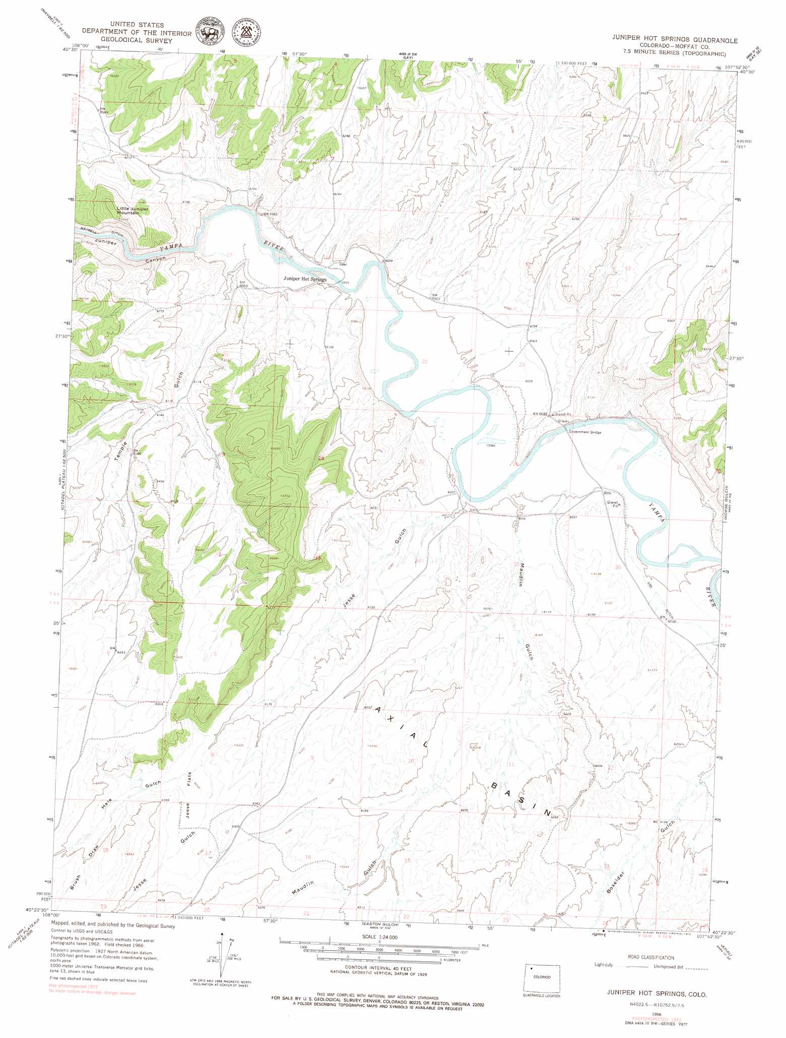
USGS Topo Quad 40107d8 - 1:24,000 scale
| Topo Map Name: | Juniper Hot Springs |
| USGS Topo Quad ID: | 40107d8 |
| Print Size: | ca. 21 1/4" wide x 27" high |
| Southeast Coordinates: | 40.375° N latitude / 107.875° W longitude |
| Map Center Coordinates: | 40.4375° N latitude / 107.9375° W longitude |
| U.S. State: | CO |
| Filename: | o40107d8.jpg |
| Download Map JPG Image: | Juniper Hot Springs topo map 1:24,000 scale |
| Map Type: | Topographic |
| Topo Series: | 7.5´ |
| Map Scale: | 1:24,000 |
| Source of Map Images: | United States Geological Survey (USGS) |
| Alternate Map Versions: |
Juniper Hot Springs CO 1966, updated 1969 Download PDF Buy paper map Juniper Hot Springs CO 1966, updated 1969 Download PDF Buy paper map Juniper Hot Springs CO 2010 Download PDF Buy paper map Juniper Hot Springs CO 2013 Download PDF Buy paper map Juniper Hot Springs CO 2016 Download PDF Buy paper map |
1:24,000 Topo Quads surrounding Juniper Hot Springs
Ninemile Hill |
Bald Mountain |
Adobe Springs |
Iron Springs |
Craig Nw |
Sunbeam |
Maybell |
Lay |
Lay Se |
Pine Ridge |
Cedar Knob |
Juniper Mountain |
Juniper Hot Springs |
Horse Gulch |
Round Bottom |
Citadel Plateau |
Price Creek |
Easton Gulch |
Axial |
Monument Butte |
Indian Valley |
White Rock |
Devils Hole Gulch |
Ninemile Gap |
Thornburgh |
> Back to 40107a1 at 1:100,000 scale
> Back to 40106a1 at 1:250,000 scale
> Back to U.S. Topo Maps home
Juniper Hot Springs topo map: Gazetteer
Juniper Hot Springs: Canals
Homestead Ditch elevation 1919m 6295′Juniper Hot Springs: Flats
Jesse Flats elevation 1911m 6269′Juniper Hot Springs: Mines
Airborne Anomaly B17-89 Mine elevation 1874m 6148′Airborne Anomaly B17-90 Mine elevation 1874m 6148′
Airborne Anomaly B17-93 Mine elevation 1874m 6148′
Airborne Anomaly B17-94 Mine elevation 1857m 6092′
Airborne Anomaly B17-95 Mine elevation 1884m 6181′
Airborne Anomaly B17-96 Mine elevation 1884m 6181′
Cedars Mining Company Claim Number One elevation 1884m 6181′
Juniper Hot Springs: Populated Places
Juniper Hot Springs elevation 1826m 5990′Juniper Hot Springs: Springs
Juniper Hot Springs elevation 1827m 5994′Juniper Hot Springs: Summits
Little Juniper Mountain elevation 2027m 6650′Juniper Hot Springs: Valleys
Brush Draw elevation 1910m 6266′Hale Gulch elevation 1899m 6230′
Jesse Gulch elevation 1827m 5994′
Maudlin Gulch elevation 1829m 6000′
Temple Gulch elevation 1823m 5980′
Juniper Hot Springs digital topo map on disk
Buy this Juniper Hot Springs topo map showing relief, roads, GPS coordinates and other geographical features, as a high-resolution digital map file on DVD: