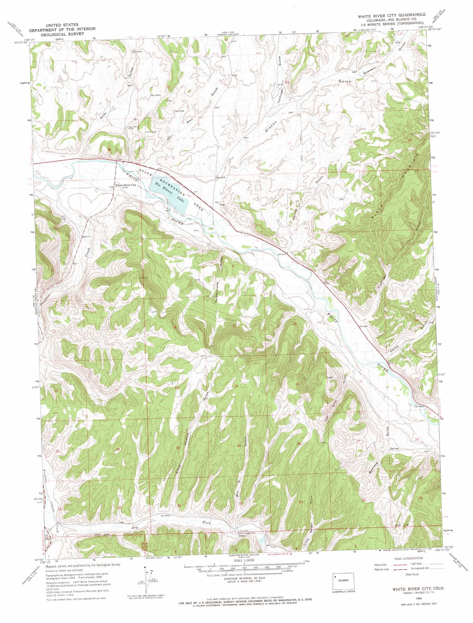
White River City Topo Map Colorado
To zoom in, hover over the map of White River City
USGS Topo Quad 40108a2 - 1:24,000 scale
| Topo Map Name: | White River City |
| USGS Topo Quad ID: | 40108a2 |
| Print Size: | ca. 21 1/4" wide x 27" high |
| Southeast Coordinates: | 40° N latitude / 108.125° W longitude |
| Map Center Coordinates: | 40.0625° N latitude / 108.1875° W longitude |
| U.S. State: | CO |
| Filename: | o40108a2.jpg |
| Download Map JPG Image: | White River City topo map 1:24,000 scale |
| Map Type: | Topographic |
| Topo Series: | 7.5´ |
| Map Scale: | 1:24,000 |
| Source of Map Images: | United States Geological Survey (USGS) |
| Alternate Map Versions: |
White River City CO 1966, updated 1969 Download PDF Buy paper map White River City CO 2010 Download PDF Buy paper map White River City CO 2013 Download PDF Buy paper map White River City CO 2016 Download PDF Buy paper map |
1:24,000 Topo Quads surrounding White River City
Elk Springs |
Wapiti Peak |
Citadel Plateau |
Price Creek |
Easton Gulch |
Rough Gulch |
Smizer Gulch |
Indian Valley |
White Rock |
Devils Hole Gulch |
Barcus Creek |
Barcus Creek Se |
White River City |
Buckskin Point |
Meeker |
Wolf Ridge |
Square S Ranch |
Greasewood Gulch |
Segar Mountain |
Lo 7 Hill |
Yankee Gulch |
Rock School |
Jessup Gulch |
No Name Ridge |
Thirteenmile Creek |
> Back to 40108a1 at 1:100,000 scale
> Back to 40108a1 at 1:250,000 scale
> Back to U.S. Topo Maps home
White River City topo map: Gazetteer
White River City: Dams
Johnnie Johnson Dam elevation 1757m 5764′White River City: Mines
U.S.B.M. Number One Shaft elevation 1857m 6092′USBM Number One Shaft elevation 1880m 6167′
White River City: Populated Places
White River City elevation 1750m 5741′White River City: Reservoirs
Rio Blanco Lake elevation 1756m 5761′White River City: Streams
Dry Fork Piceance Creek elevation 1796m 5892′Piceance Creek elevation 1738m 5702′
White River City: Valleys
Beavers Gulch elevation 1799m 5902′Beefsteak Gulch elevation 1813m 5948′
Blacks Gulch elevation 1761m 5777′
Box D Gulch elevation 1872m 6141′
Ernie Howard Gulch elevation 1840m 6036′
Kellog Gulch elevation 1768m 5800′
Kissinger Gulch elevation 1795m 5889′
Oil Well Gulch elevation 1756m 5761′
Rattlesnake Gulch elevation 1764m 5787′
Scenery Gulch elevation 1811m 5941′
Smith Gulch elevation 1787m 5862′
Tom Stith Gulch elevation 1786m 5859′
Tschuddi Gulch elevation 1785m 5856′
Wray Gulch elevation 1751m 5744′
White River City digital topo map on disk
Buy this White River City topo map showing relief, roads, GPS coordinates and other geographical features, as a high-resolution digital map file on DVD: