Taylor Mountain Topo Map Utah
To zoom in, hover over the map of Taylor Mountain
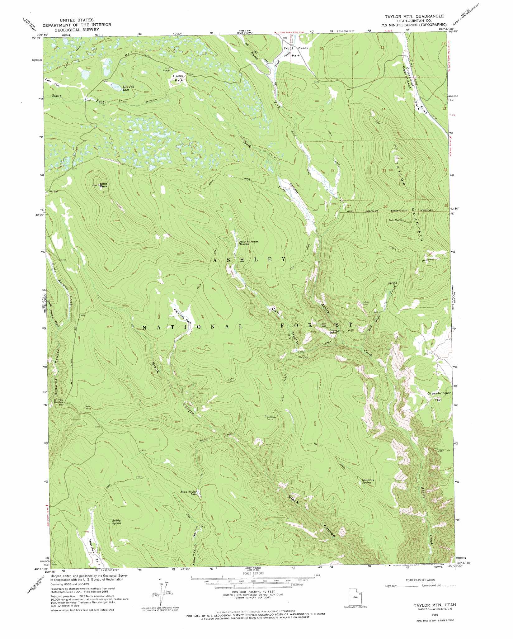
USGS Topo Quad 40109f6 - 1:24,000 scale
| Topo Map Name: | Taylor Mountain |
| USGS Topo Quad ID: | 40109f6 |
| Print Size: | ca. 21 1/4" wide x 27" high |
| Southeast Coordinates: | 40.625° N latitude / 109.625° W longitude |
| Map Center Coordinates: | 40.6875° N latitude / 109.6875° W longitude |
| U.S. State: | UT |
| Filename: | o40109f6.jpg |
| Download Map JPG Image: | Taylor Mountain topo map 1:24,000 scale |
| Map Type: | Topographic |
| Topo Series: | 7.5´ |
| Map Scale: | 1:24,000 |
| Source of Map Images: | United States Geological Survey (USGS) |
| Alternate Map Versions: |
Taylor Mtn UT 1966, updated 1968 Download PDF Buy paper map Taylor Mountain UT 1996, updated 1999 Download PDF Buy paper map Taylor Mountain UT 2011 Download PDF Buy paper map Taylor Mountain UT 2014 Download PDF Buy paper map |
| FStopo: | US Forest Service topo Taylor Mountain is available: Download FStopo PDF Download FStopo TIF |
1:24,000 Topo Quads surrounding Taylor Mountain
Phil Pico Mountain |
Jessen Butte |
Manila |
Flaming Gorge |
Dutch John |
Whiterocks Lake |
Leidy Peak |
Elk Park |
East Park Reservoir |
Mount Lena |
Paradise Park |
Marsh Peak |
Taylor Mountain |
Dyer Mountain |
Burnt Cabin Gorge |
Ice Cave Peak |
Lake Mountain |
Dry Fork |
Steinaker Reservoir |
Donkey Flat |
Whiterocks |
Lapoint |
Vernal Nw |
Vernal Ne |
Naples |
> Back to 40109e1 at 1:100,000 scale
> Back to 40108a1 at 1:250,000 scale
> Back to U.S. Topo Maps home
Taylor Mountain topo map: Gazetteer
Taylor Mountain: Flats
Death of James Meadow elevation 2754m 9035′Deer Park elevation 2974m 9757′
Government Park elevation 2792m 9160′
Grasshopper Flat elevation 2595m 8513′
Hicks Park elevation 2868m 9409′
Trout Creek Park elevation 2828m 9278′
Taylor Mountain: Lakes
Alma Taylor Lake elevation 2743m 8999′Lily Pad Lake elevation 2939m 9642′
Taylor Mountain: Springs
Bodily Spring elevation 2756m 9041′Galloway Spring elevation 2614m 8576′
Taylor Mountain: Streams
Black Canyon Creek elevation 2578m 8458′North Brownie Creek elevation 2821m 9255′
North Fork Ashley Creek elevation 2678m 8786′
Red Pine Creek elevation 2344m 7690′
South Brownie Creek elevation 2821m 9255′
South Fork Ashley Creek elevation 2680m 8792′
Trout Creek elevation 2815m 9235′
Taylor Mountain: Summits
Frenches Peak elevation 2811m 9222′Sims Peak elevation 3141m 10305′
Taylor Mountain elevation 3103m 10180′
Taylor Mountain: Valleys
Cow Hollow elevation 2427m 7962′Sinbad Canyon elevation 3149m 10331′
Taylor Mountain digital topo map on disk
Buy this Taylor Mountain topo map showing relief, roads, GPS coordinates and other geographical features, as a high-resolution digital map file on DVD: