Flaming Gorge Topo Map Utah
To zoom in, hover over the map of Flaming Gorge
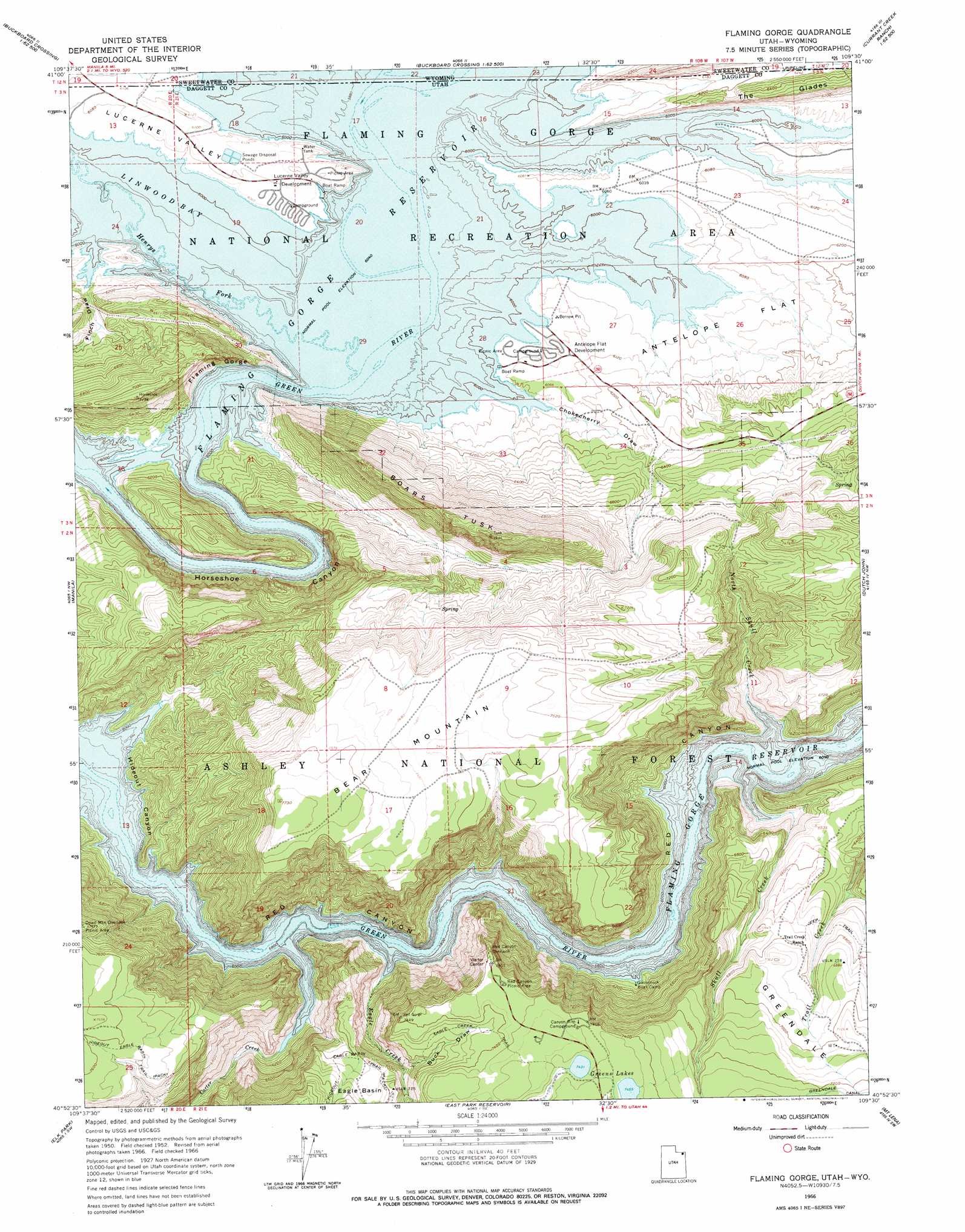
USGS Topo Quad 40109h5 - 1:24,000 scale
| Topo Map Name: | Flaming Gorge |
| USGS Topo Quad ID: | 40109h5 |
| Print Size: | ca. 21 1/4" wide x 27" high |
| Southeast Coordinates: | 40.875° N latitude / 109.5° W longitude |
| Map Center Coordinates: | 40.9375° N latitude / 109.5625° W longitude |
| U.S. States: | UT, WY |
| Filename: | o40109h5.jpg |
| Download Map JPG Image: | Flaming Gorge topo map 1:24,000 scale |
| Map Type: | Topographic |
| Topo Series: | 7.5´ |
| Map Scale: | 1:24,000 |
| Source of Map Images: | United States Geological Survey (USGS) |
| Alternate Map Versions: |
Flaming Gorge UT 1952, updated 1954 Download PDF Buy paper map Flaming Gorge UT 1952, updated 1955 Download PDF Buy paper map Flaming Gorge UT 1966, updated 1967 Download PDF Buy paper map Flaming Gorge UT 1966, updated 1977 Download PDF Buy paper map Flaming George UT 1996, updated 1999 Download PDF Buy paper map Flaming Gorge UT 2011 Download PDF Buy paper map Flaming Gorge UT 2014 Download PDF Buy paper map |
| FStopo: | US Forest Service topo Flaming Gorge is available: Download FStopo PDF Download FStopo TIF |
1:24,000 Topo Quads surrounding Flaming Gorge
Black Spring Reservoir |
Devils Playground |
Haystack Buttes North |
Sugarloaf Basin |
Big Ridge |
Antelope Wash |
Linwood Canyon |
Haystack Buttes South |
Minnies Gap |
Hawks Nest |
Jessen Butte |
Manila |
Flaming Gorge |
Dutch John |
Goslin Mountain |
Leidy Peak |
Elk Park |
East Park Reservoir |
Mount Lena |
Jackson Draw |
Marsh Peak |
Taylor Mountain |
Dyer Mountain |
Burnt Cabin Gorge |
Blair Basin |
> Back to 40109e1 at 1:100,000 scale
> Back to 40108a1 at 1:250,000 scale
> Back to U.S. Topo Maps home
Flaming Gorge topo map: Gazetteer
Flaming Gorge: Basins
Eagle Basin elevation 2167m 7109′Flaming Gorge: Bays
Linwood Bay elevation 1842m 6043′Flaming Gorge: Falls
Ashley Falls elevation 1843m 6046′Flaming Gorge: Lakes
Greens Lakes elevation 2272m 7454′Flaming Gorge: Parks
Lucerne Point Group Site elevation 1856m 6089′Flaming Gorge: Ridges
Boars Tusk elevation 2332m 7650′Flaming Gorge: Streams
Carter Creek elevation 1842m 6043′Eagle Creek elevation 1842m 6043′
Henrys Fork elevation 1842m 6043′
North Skull Creek elevation 1842m 6043′
Skull Creek elevation 1842m 6043′
Spring Creek elevation 1842m 6043′
West Fork Eagle Creek elevation 2128m 6981′
Flaming Gorge: Summits
Bare Top Mountain elevation 2273m 7457′Flaming Gorge: Trails
Hideout Eagle Basin Trail elevation 2139m 7017′Flaming Gorge: Valleys
Buck Draw elevation 2089m 6853′Campbell Draw elevation 1847m 6059′
Chokecherry Draw elevation 1842m 6043′
Finch Draw elevation 1849m 6066′
Flaming Gorge (historical) elevation 1842m 6043′
Flaming Gorge Valley elevation 1842m 6043′
Hideout Canyon elevation 1842m 6043′
Horseshoe Canyon elevation 1842m 6043′
Lucerne Valley elevation 1843m 6046′
Flaming Gorge digital topo map on disk
Buy this Flaming Gorge topo map showing relief, roads, GPS coordinates and other geographical features, as a high-resolution digital map file on DVD: