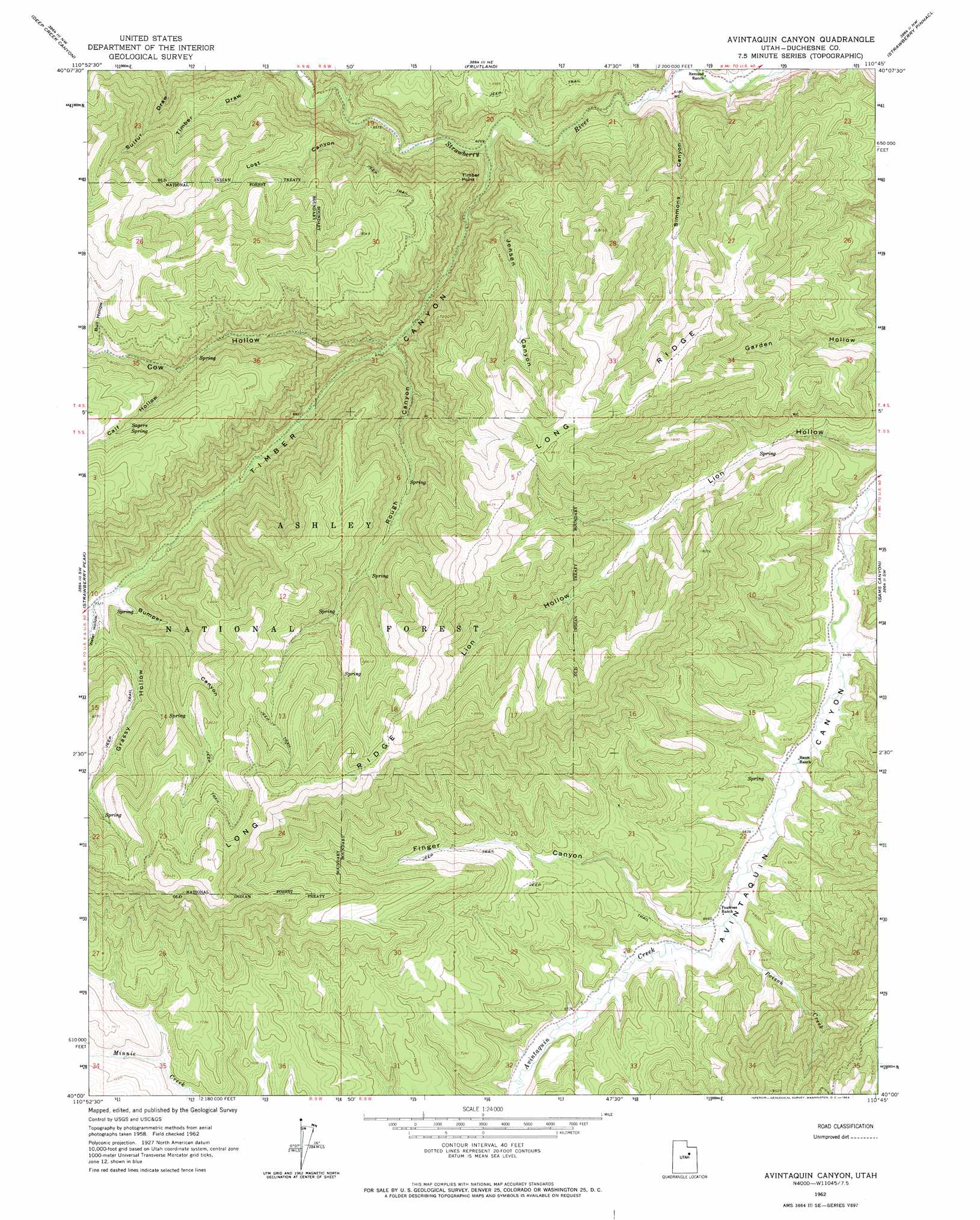
Avintaquin Canyon Topo Map Utah
To zoom in, hover over the map of Avintaquin Canyon
USGS Topo Quad 40110a7 - 1:24,000 scale
| Topo Map Name: | Avintaquin Canyon |
| USGS Topo Quad ID: | 40110a7 |
| Print Size: | ca. 21 1/4" wide x 27" high |
| Southeast Coordinates: | 40° N latitude / 110.75° W longitude |
| Map Center Coordinates: | 40.0625° N latitude / 110.8125° W longitude |
| U.S. State: | UT |
| Filename: | o40110a7.jpg |
| Download Map JPG Image: | Avintaquin Canyon topo map 1:24,000 scale |
| Map Type: | Topographic |
| Topo Series: | 7.5´ |
| Map Scale: | 1:24,000 |
| Source of Map Images: | United States Geological Survey (USGS) |
| Alternate Map Versions: |
Avintaquin Canyon UT 1962, updated 1964 Download PDF Buy paper map Avintaquin Canyon UT 1996, updated 1999 Download PDF Buy paper map Avintaquin Canyon UT 2011 Download PDF Buy paper map Avintaquin Canyon UT 2014 Download PDF Buy paper map |
| FStopo: | US Forest Service topo Avintaquin Canyon is available: Download FStopo PDF Download FStopo TIF |
1:24,000 Topo Quads surrounding Avintaquin Canyon
Jimmies Point |
Raspberry Knoll |
Tabby Mountain |
Tabiona |
Blacktail Mountain |
Strawberry Reservoir Ne |
Deep Creek Canyon |
Fruitland |
Strawberry Pinnacles |
Rabbit Gulch |
Strawberry Reservoir Se |
Strawberry Peak |
Avintaquin Canyon |
Sams Canyon |
Buck Knoll |
Soldier Summit |
Flat Ridge |
Gray Head Peak |
Jones Hollow |
Lance Canyon |
Colton |
Kyune |
Matts Summit |
Minnie Maud Creek West |
Minnie Maud Creek East |
> Back to 40110a1 at 1:100,000 scale
> Back to 40110a1 at 1:250,000 scale
> Back to U.S. Topo Maps home
Avintaquin Canyon topo map: Gazetteer
Avintaquin Canyon: Cliffs
Timber Point elevation 2185m 7168′Avintaquin Canyon: Ridges
Long Ridge elevation 2701m 8861′Avintaquin Canyon: Springs
Sagers Spring elevation 2477m 8126′Avintaquin Canyon: Streams
Poison Creek elevation 2018m 6620′Avintaquin Canyon: Valleys
Bull Hollow elevation 2410m 7906′Bumper Canyon elevation 2217m 7273′
Calf Hollow elevation 2318m 7604′
Cow Hollow elevation 2047m 6715′
Finger Canyon elevation 2035m 6676′
Grassy Hollow elevation 2237m 7339′
Lost Canyon elevation 1947m 6387′
Rough Canyon elevation 2049m 6722′
Simmons Canyon elevation 1887m 6190′
Sulfur Draw elevation 1986m 6515′
Timber Canyon elevation 1909m 6263′
Avintaquin Canyon digital topo map on disk
Buy this Avintaquin Canyon topo map showing relief, roads, GPS coordinates and other geographical features, as a high-resolution digital map file on DVD: