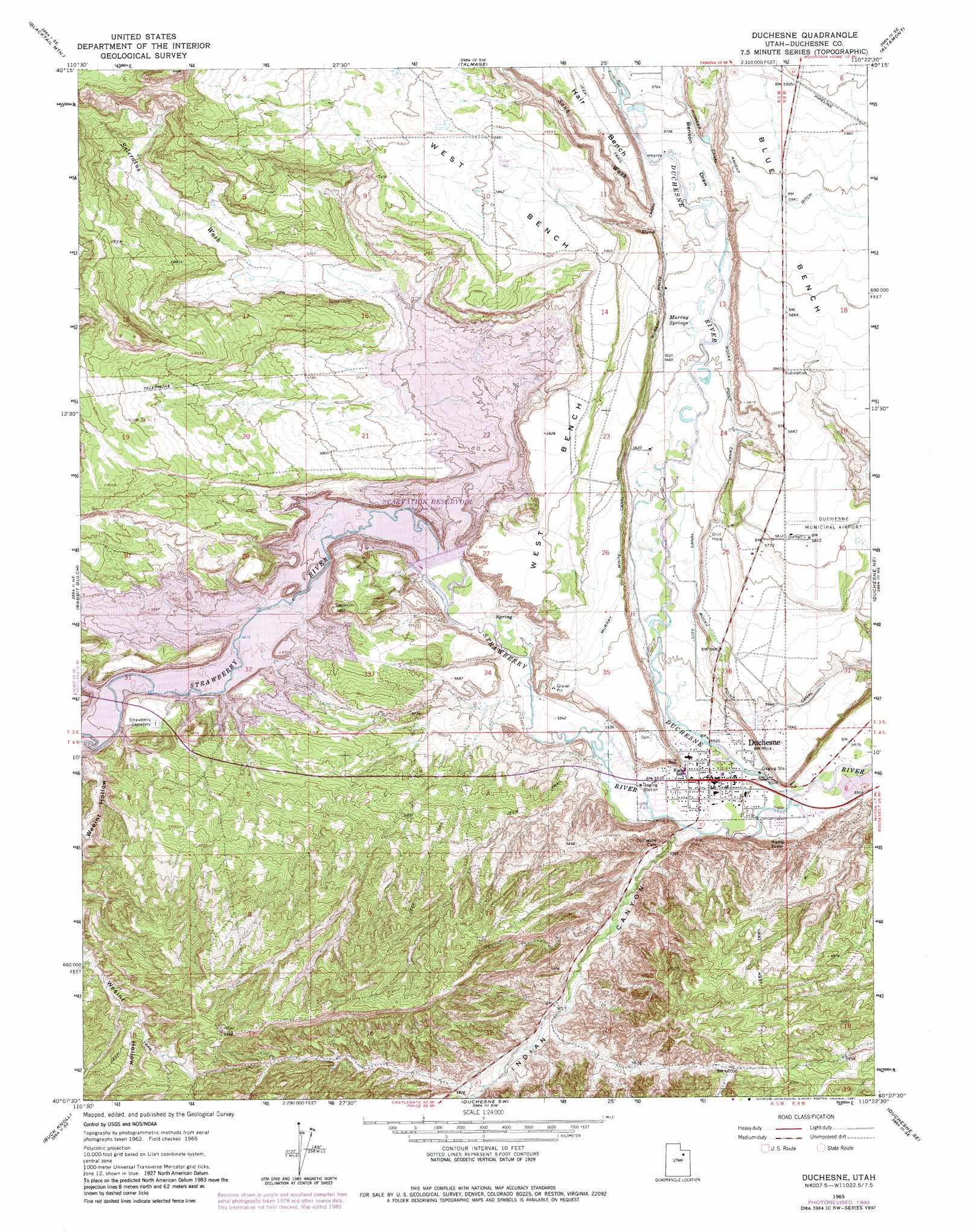
Duchesne Topo Map Utah
To zoom in, hover over the map of Duchesne
USGS Topo Quad 40110b4 - 1:24,000 scale
| Topo Map Name: | Duchesne |
| USGS Topo Quad ID: | 40110b4 |
| Print Size: | ca. 21 1/4" wide x 27" high |
| Southeast Coordinates: | 40.125° N latitude / 110.375° W longitude |
| Map Center Coordinates: | 40.1875° N latitude / 110.4375° W longitude |
| U.S. State: | UT |
| Filename: | o40110b4.jpg |
| Download Map JPG Image: | Duchesne topo map 1:24,000 scale |
| Map Type: | Topographic |
| Topo Series: | 7.5´ |
| Map Scale: | 1:24,000 |
| Source of Map Images: | United States Geological Survey (USGS) |
| Alternate Map Versions: |
Duchesne UT 1965, updated 1967 Download PDF Buy paper map Duchesne UT 1965, updated 1981 Download PDF Buy paper map Duchesne UT 2010 Download PDF Buy paper map Duchesne UT 2014 Download PDF Buy paper map |
1:24,000 Topo Quads surrounding Duchesne
Farm Creek Peak |
Dry Mountain |
Mountain Home |
Altonah |
Neola Nw |
Tabiona |
Blacktail Mountain |
Talmage |
Altamont |
Bluebell |
Strawberry Pinnacles |
Rabbit Gulch |
Duchesne |
Duchesne Ne |
Bridgeland |
Sams Canyon |
Buck Knoll |
Duchesne Sw |
Duchesne Se |
Myton Sw |
Jones Hollow |
Lance Canyon |
Anthro Mountain |
Anthro Mountain Ne |
Gilsonite Draw |
> Back to 40110a1 at 1:100,000 scale
> Back to 40110a1 at 1:250,000 scale
> Back to U.S. Topo Maps home
Duchesne topo map: Gazetteer
Duchesne: Airports
Duchesne Municipal Airport elevation 1770m 5807′Duchesne: Benches
West Bench elevation 1804m 5918′Duchesne: Bends
Pulley Bend elevation 1740m 5708′Duchesne: Canals
City Canal elevation 1702m 5583′Murray White Canal elevation 1763m 5784′
Rocky Point Canal elevation 1729m 5672′
Duchesne: Dams
Starvation Dam elevation 1714m 5623′Duchesne: Parks
Starvation State Park elevation 1745m 5725′Duchesne: Populated Places
Duchesne elevation 1682m 5518′Duchesne: Reservoirs
Starvation Reservoir elevation 1714m 5623′Duchesne: Springs
Murray Springs elevation 1730m 5675′Duchesne: Streams
Benson Creek elevation 1734m 5688′Strawberry River elevation 1674m 5492′
Duchesne: Valleys
Benson Draw elevation 1736m 5695′Indian Canyon elevation 1681m 5515′
Rabbit Gulch elevation 1740m 5708′
Saleratus Wash elevation 1740m 5708′
Sand Wash elevation 1738m 5702′
Duchesne digital topo map on disk
Buy this Duchesne topo map showing relief, roads, GPS coordinates and other geographical features, as a high-resolution digital map file on DVD: