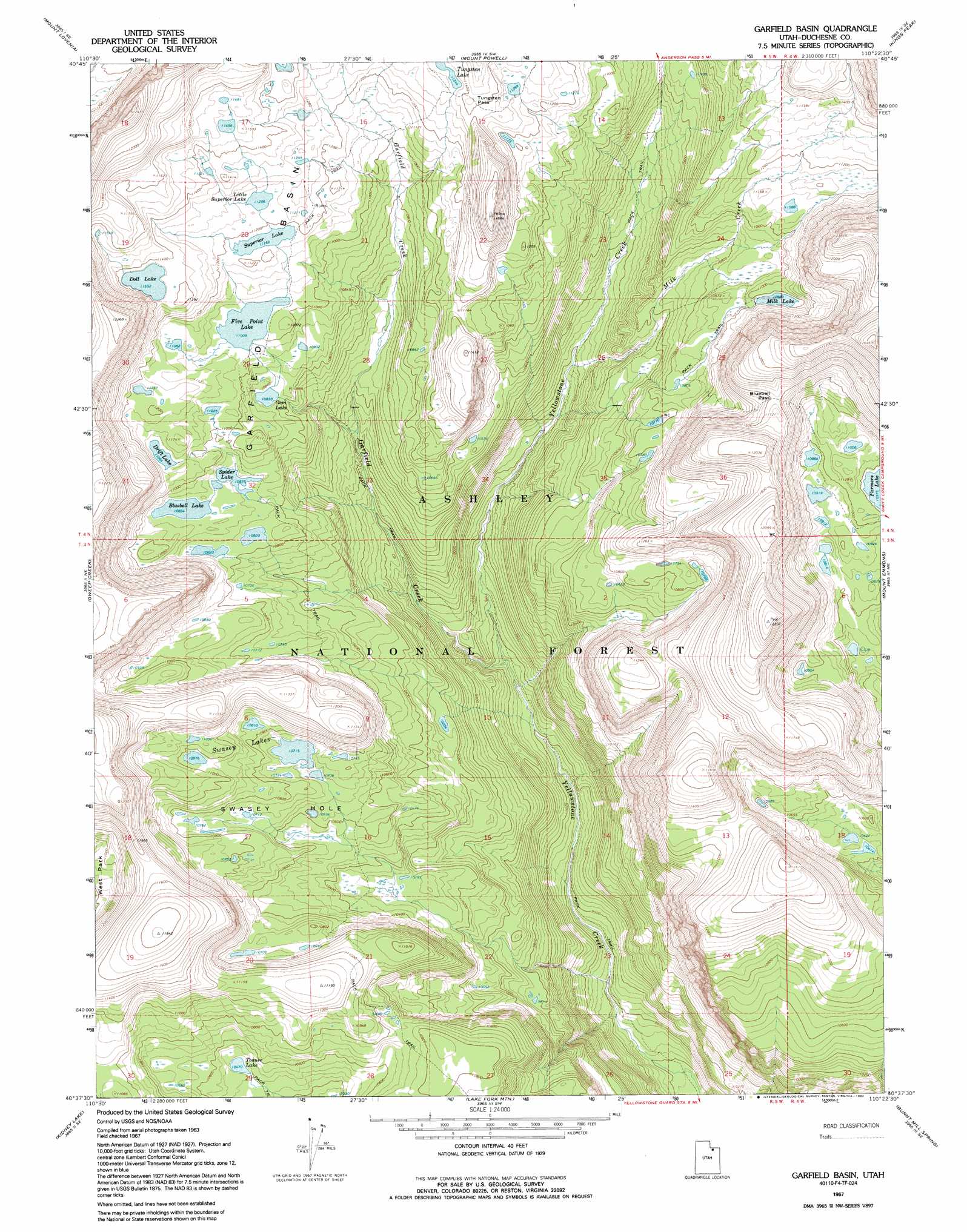
Garfield Basin Topo Map Utah
To zoom in, hover over the map of Garfield Basin
USGS Topo Quad 40110f4 - 1:24,000 scale
| Topo Map Name: | Garfield Basin |
| USGS Topo Quad ID: | 40110f4 |
| Print Size: | ca. 21 1/4" wide x 27" high |
| Southeast Coordinates: | 40.625° N latitude / 110.375° W longitude |
| Map Center Coordinates: | 40.6875° N latitude / 110.4375° W longitude |
| U.S. State: | UT |
| Filename: | o40110f4.jpg |
| Download Map JPG Image: | Garfield Basin topo map 1:24,000 scale |
| Map Type: | Topographic |
| Topo Series: | 7.5´ |
| Map Scale: | 1:24,000 |
| Source of Map Images: | United States Geological Survey (USGS) |
| Alternate Map Versions: |
Garfield Basin UT 1967, updated 1969 Download PDF Buy paper map Garfield Basin UT 1967, updated 1992 Download PDF Buy paper map Garfield Basin UT 1996, updated 2000 Download PDF Buy paper map Garfield Basin UT 2011 Download PDF Buy paper map Garfield Basin UT 2014 Download PDF Buy paper map |
| FStopo: | US Forest Service topo Garfield Basin is available: Download FStopo PDF Download FStopo TIF |
1:24,000 Topo Quads surrounding Garfield Basin
Elizabeth Mountain |
Lyman Lake |
Bridger Lake |
Gilbert Peak Ne |
Hole In The Rock |
Red Knob |
Mount Lovenia |
Mount Powell |
Kings Peak |
Fox Lake |
Explorer Peak |
Oweep Creek |
Garfield Basin |
Mount Emmons |
Bollie Lake |
Tworoose Pass |
Kidney Lake |
Lake Fork Mountain |
Burnt Mill Spring |
Heller Lake |
Farm Creek Peak |
Dry Mountain |
Mountain Home |
Altonah |
Neola Nw |
> Back to 40110e1 at 1:100,000 scale
> Back to 40110a1 at 1:250,000 scale
> Back to U.S. Topo Maps home
Garfield Basin topo map: Gazetteer
Garfield Basin: Basins
Garfield Basin elevation 3424m 11233′Garfield Basin: Bends
Swasey Hole elevation 3264m 10708′Garfield Basin: Dams
Drift Lake Dam elevation 3374m 11069′Five Point Lake Dam elevation 3357m 11013′
Milk Lake Dam elevation 3351m 10994′
Superior Lake Dam elevation 3404m 11167′
Garfield Basin: Gaps
Bluebell Pass elevation 3543m 11624′Tungsten Pass elevation 3483m 11427′
Garfield Basin: Lakes
Bluebell Lake elevation 3322m 10898′Doll Lake elevation 3462m 11358′
Farmers Lake elevation 3345m 10974′
Gem Lake elevation 3303m 10836′
Little Superior Lake elevation 3418m 11213′
Spider Lake elevation 3317m 10882′
Swasey Lakes elevation 3297m 10816′
Toquer Lake elevation 3193m 10475′
Tungsten Lake elevation 3464m 11364′
Garfield Basin: Reservoirs
Drift Lake elevation 3374m 11069′Five Point Lake elevation 3357m 11013′
Milk Lake elevation 3351m 10994′
Superior Lake elevation 3404m 11167′
Garfield Basin: Streams
Garfield Creek elevation 2841m 9320′Milk Creek elevation 3054m 10019′
Garfield Basin digital topo map on disk
Buy this Garfield Basin topo map showing relief, roads, GPS coordinates and other geographical features, as a high-resolution digital map file on DVD: