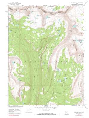
Explorer Peak Topo Map Utah
To zoom in, hover over the map of Explorer Peak
USGS Topo Quad 40110f6 - 1:24,000 scale
| Topo Map Name: | Explorer Peak |
| USGS Topo Quad ID: | 40110f6 |
| Print Size: | ca. 21 1/4" wide x 27" high |
| Southeast Coordinates: | 40.625° N latitude / 110.625° W longitude |
| Map Center Coordinates: | 40.6875° N latitude / 110.6875° W longitude |
| U.S. State: | UT |
| Filename: | o40110f6.jpg |
| Download Map JPG Image: | Explorer Peak topo map 1:24,000 scale |
| Map Type: | Topographic |
| Topo Series: | 7.5´ |
| Map Scale: | 1:24,000 |
| Source of Map Images: | United States Geological Survey (USGS) |
| Alternate Map Versions: |
Explorer Peak UT 1967, updated 1968 Download PDF Buy paper map Explorer Peak UT 1967, updated 1990 Download PDF Buy paper map Explorer Peak UT 1967, updated 1990 Download PDF Buy paper map Explorer Peak UT 1996, updated 2000 Download PDF Buy paper map Explorer Peak UT 2011 Download PDF Buy paper map Explorer Peak UT 2014 Download PDF Buy paper map |
| FStopo: | US Forest Service topo Explorer Peak is available: Download FStopo PDF Download FStopo TIF |
1:24,000 Topo Quads surrounding Explorer Peak
> Back to 40110e1 at 1:100,000 scale
> Back to 40110a1 at 1:250,000 scale
> Back to U.S. Topo Maps home
Explorer Peak topo map: Gazetteer
Explorer Peak: Areas
Big Meadow elevation 3008m 9868′Explorer Peak: Basins
Squaw Basin elevation 3066m 10059′Explorer Peak: Gaps
Cyclone Pass elevation 3377m 11079′Dead Horse Pass elevation 3484m 11430′
Explorer Peak: Lakes
Anderson Lake elevation 3229m 10593′Bench Lake elevation 3341m 10961′
Black Lake elevation 3178m 10426′
Boot Lake elevation 3388m 11115′
Brinkley Lake elevation 3194m 10479′
Continent Lake elevation 3441m 11289′
Crater Lake elevation 3436m 11272′
Dead Horse Lake elevation 3312m 10866′
Doug Lake elevation 3375m 11072′
Fall Lakes elevation 3273m 10738′
Francis Lake elevation 3034m 9954′
Helen Lake elevation 3330m 10925′
Jack and Jill Lake elevation 3193m 10475′
Jodie Lake elevation 3341m 10961′
Ledge Lake elevation 3313m 10869′
Lower Ottoson Lake elevation 3379m 11085′
Ouray Lake elevation 3169m 10396′
Phinney Lake elevation 3240m 10629′
Reconnaissance Lake elevation 3401m 11158′
Rock Lakes elevation 3222m 10570′
Sea Lion Lake elevation 3167m 10390′
Shamrock Lake elevation 3161m 10370′
Slide Lake elevation 3109m 10200′
Squaw Lake elevation 3203m 10508′
Thompson Lake elevation 3260m 10695′
Triangle Lake elevation 3378m 11082′
Upper Ottoson Lake elevation 3389m 11118′
Young Lake elevation 3146m 10321′
Explorer Peak: Streams
Fall Creek elevation 2791m 9156′Squaw Basin Creek elevation 3008m 9868′
Explorer Peak: Summits
Cleveland Peak elevation 3837m 12588′Explorer Peak elevation 3870m 12696′
Squaw Peak elevation 3919m 12857′
Explorer Peak digital topo map on disk
Buy this Explorer Peak topo map showing relief, roads, GPS coordinates and other geographical features, as a high-resolution digital map file on DVD:


