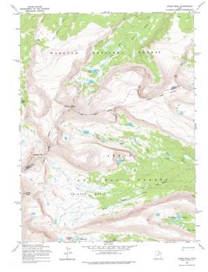
Kings Peak Topo Map Utah
To zoom in, hover over the map of Kings Peak
USGS Topo Quad 40110g3 - 1:24,000 scale
| Topo Map Name: | Kings Peak |
| USGS Topo Quad ID: | 40110g3 |
| Print Size: | ca. 21 1/4" wide x 27" high |
| Southeast Coordinates: | 40.75° N latitude / 110.25° W longitude |
| Map Center Coordinates: | 40.8125° N latitude / 110.3125° W longitude |
| U.S. State: | UT |
| Filename: | o40110g3.jpg |
| Download Map JPG Image: | Kings Peak topo map 1:24,000 scale |
| Map Type: | Topographic |
| Topo Series: | 7.5´ |
| Map Scale: | 1:24,000 |
| Source of Map Images: | United States Geological Survey (USGS) |
| Alternate Map Versions: |
Kings Peak UT 1965, updated 1967 Download PDF Buy paper map Kings Peak UT 1965, updated 1976 Download PDF Buy paper map Kings Peak UT 1965, updated 1976 Download PDF Buy paper map Kings Peak UT 1996, updated 1999 Download PDF Buy paper map Kings Peak UT 2011 Download PDF Buy paper map Kings Peak UT 2014 Download PDF Buy paper map |
| FStopo: | US Forest Service topo Kings Peak is available: Download FStopo PDF Download FStopo TIF |
1:24,000 Topo Quads surrounding Kings Peak
> Back to 40110e1 at 1:100,000 scale
> Back to 40110a1 at 1:250,000 scale
> Back to U.S. Topo Maps home
Kings Peak topo map: Gazetteer
Kings Peak: Basins
Gilbert Creek Basin elevation 3492m 11456′Painter Basin elevation 3410m 11187′
Kings Peak: Gaps
Gunsight Pass elevation 3626m 11896′Trail Rider Pass elevation 3572m 11719′
Kings Peak: Lakes
Gilbert Lake elevation 3326m 10912′Lake George Beard elevation 3483m 11427′
Milk Lake elevation 3426m 11240′
Painter Lakes elevation 3366m 11043′
Kings Peak: Streams
Center Fork Gilbert Creek elevation 3292m 10800′North Fork Gilbert Creek elevation 3278m 10754′
Kings Peak: Summits
Gilbert Peak elevation 4095m 13435′Kings Peak elevation 4121m 13520′
Kings Peak digital topo map on disk
Buy this Kings Peak topo map showing relief, roads, GPS coordinates and other geographical features, as a high-resolution digital map file on DVD:


