Strawberry Reservoir Nw Topo Map Utah
To zoom in, hover over the map of Strawberry Reservoir Nw
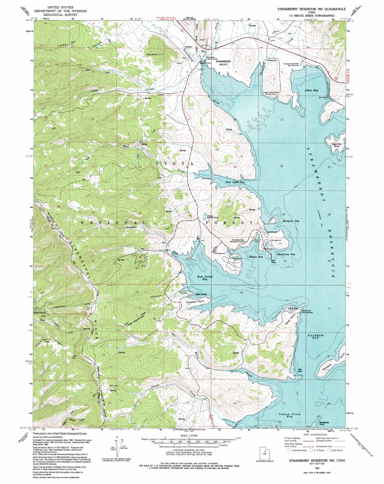
USGS Topo Quad 40111b2 - 1:24,000 scale
| Topo Map Name: | Strawberry Reservoir Nw |
| USGS Topo Quad ID: | 40111b2 |
| Print Size: | ca. 21 1/4" wide x 27" high |
| Southeast Coordinates: | 40.125° N latitude / 111.125° W longitude |
| Map Center Coordinates: | 40.1875° N latitude / 111.1875° W longitude |
| U.S. State: | UT |
| Filename: | o40111b2.jpg |
| Download Map JPG Image: | Strawberry Reservoir Nw topo map 1:24,000 scale |
| Map Type: | Topographic |
| Topo Series: | 7.5´ |
| Map Scale: | 1:24,000 |
| Source of Map Images: | United States Geological Survey (USGS) |
| Alternate Map Versions: |
Strawberry Reservoir NW UT 1966, updated 1968 Download PDF Buy paper map Strawberry Reservoir NW UT 1966, updated 1978 Download PDF Buy paper map Strawberry Reservoir NW UT 1994, updated 1994 Download PDF Buy paper map Strawberry Reservoir NW UT 1998, updated 2002 Download PDF Buy paper map Strawberry Reservoir NW UT 2011 Download PDF Buy paper map Strawberry Reservoir NW UT 2014 Download PDF Buy paper map |
| FStopo: | US Forest Service topo Strawberry Reservoir NW is available: Download FStopo PDF Download FStopo TIF |
1:24,000 Topo Quads surrounding Strawberry Reservoir Nw
Charleston |
Center Creek |
Heber Mountain |
Wolf Creek Summit |
Wolf Creek |
Wallsburg Ridge |
Twin Peaks |
Co-Op Creek |
Jimmies Point |
Raspberry Knoll |
Granger Mountain |
Two Tom Hill |
Strawberry Reservoir Nw |
Strawberry Reservoir Ne |
Deep Creek Canyon |
Billies Mountain |
Rays Valley |
Strawberry Reservoir Sw |
Strawberry Reservoir Se |
Strawberry Peak |
Thistle |
Mill Fork |
Tucker |
Soldier Summit |
Flat Ridge |
> Back to 40111a1 at 1:100,000 scale
> Back to 40110a1 at 1:250,000 scale
> Back to U.S. Topo Maps home
Strawberry Reservoir Nw topo map: Gazetteer
Strawberry Reservoir Nw: Airports
Rocky Mountain Helicopters Incorporated Heliport (historical) elevation 2389m 7837′Strawberry Reservoir Nw: Basins
Strawberry Valley elevation 2310m 7578′Strawberry Reservoir Nw: Canals
Indian Creek Diversion Canal elevation 2310m 7578′Strawberry Reservoir Nw: Capes
Haws Point elevation 2353m 7719′Strawberry Reservoir Nw: Dams
Midview Dam elevation 2329m 7641′Strawberry Reservoir Nw: Levees
Indian Bay Dike (historical) elevation 2310m 7578′Strawberry Reservoir Nw: Parks
Strawberry Bay Recreation Complex elevation 2327m 7634′Strawberry Reservoir Nw: Populated Places
Bryants Fork Summer Home Area elevation 2310m 7578′Strawberry Reservoir Nw: Ridges
Strawberry Ridge elevation 2612m 8569′Strawberry Reservoir Nw: Streams
Bryants Fork elevation 2310m 7578′Chicken Creek elevation 2310m 7578′
Clyde Creek elevation 2318m 7604′
Co-op Creek elevation 2318m 7604′
Horse Creek elevation 2310m 7578′
Little Co-op Creek elevation 2323m 7621′
Mud Creek elevation 2310m 7578′
Strawberry Reservoir Nw: Summits
Doe Knoll elevation 2493m 8179′Strawberry Reservoir Nw: Tunnels
Strawberry Tunnel elevation 2567m 8421′Strawberry Reservoir Nw: Valleys
Jones Hollow elevation 2362m 7749′Strawberry Reservoir Nw digital topo map on disk
Buy this Strawberry Reservoir Nw topo map showing relief, roads, GPS coordinates and other geographical features, as a high-resolution digital map file on DVD: