Center Creek Topo Map Utah
To zoom in, hover over the map of Center Creek
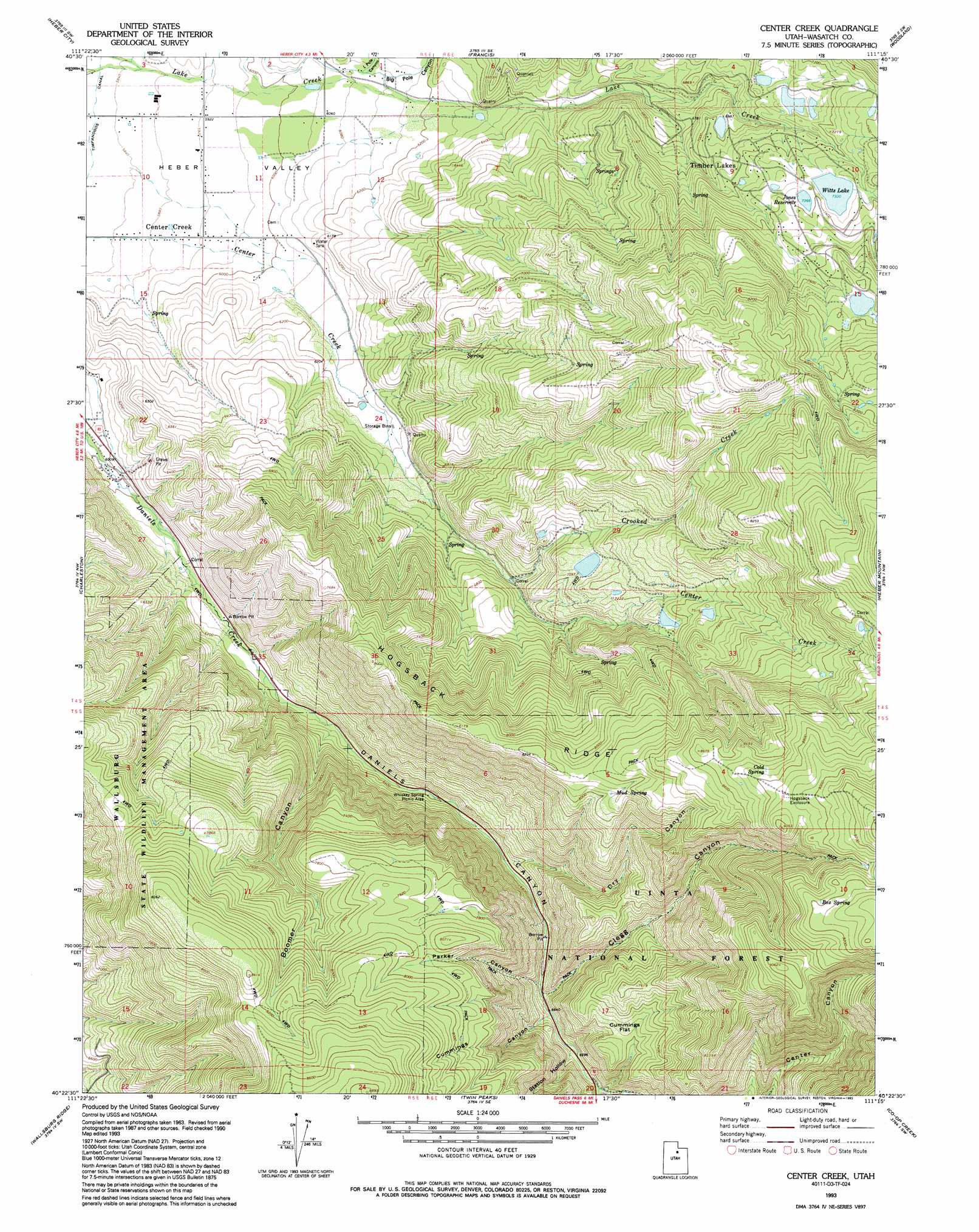
USGS Topo Quad 40111d3 - 1:24,000 scale
| Topo Map Name: | Center Creek |
| USGS Topo Quad ID: | 40111d3 |
| Print Size: | ca. 21 1/4" wide x 27" high |
| Southeast Coordinates: | 40.375° N latitude / 111.25° W longitude |
| Map Center Coordinates: | 40.4375° N latitude / 111.3125° W longitude |
| U.S. State: | UT |
| Filename: | o40111d3.jpg |
| Download Map JPG Image: | Center Creek topo map 1:24,000 scale |
| Map Type: | Topographic |
| Topo Series: | 7.5´ |
| Map Scale: | 1:24,000 |
| Source of Map Images: | United States Geological Survey (USGS) |
| Alternate Map Versions: |
Center Creek UT 1967, updated 1969 Download PDF Buy paper map Center Creek UT 1967, updated 1978 Download PDF Buy paper map Center Creek UT 1993, updated 1993 Download PDF Buy paper map Center Creek UT 1998, updated 2000 Download PDF Buy paper map Center Creek UT 2011 Download PDF Buy paper map Center Creek UT 2014 Download PDF Buy paper map |
| FStopo: | US Forest Service topo Center Creek is available: Download FStopo PDF Download FStopo TIF |
1:24,000 Topo Quads surrounding Center Creek
Park City West |
Park City East |
Kamas |
Hoyt Peak |
Erickson Basin |
Brighton |
Heber City |
Francis |
Woodland |
Soapstone Basin |
Aspen Grove |
Charleston |
Center Creek |
Heber Mountain |
Wolf Creek Summit |
Bridal Veil Falls |
Wallsburg Ridge |
Twin Peaks |
Co-Op Creek |
Jimmies Point |
Springville |
Granger Mountain |
Two Tom Hill |
Strawberry Reservoir Nw |
Strawberry Reservoir Ne |
> Back to 40111a1 at 1:100,000 scale
> Back to 40110a1 at 1:250,000 scale
> Back to U.S. Topo Maps home
Center Creek topo map: Gazetteer
Center Creek: Dams
Barnes Reservoir Dam elevation 2111m 6925′Bennett Lindsay Lower Dam elevation 2229m 7312′
Center Creek Number One Dam elevation 2163m 7096′
Center Creek Number Three Dam elevation 2288m 7506′
Center Creek Number Two Dam elevation 2237m 7339′
Clyde Lake Dam elevation 2197m 7208′
Deer Valley Dam elevation 2352m 7716′
Jones Dam elevation 2246m 7368′
Kenneth Anderson Dam elevation 2143m 7030′
Witts Lake Dam elevation 2233m 7326′
Center Creek: Flats
Cummings Flat elevation 2209m 7247′Center Creek: Populated Places
Center Creek elevation 1807m 5928′Center Creek: Reservoirs
Barnes Reservoir elevation 2111m 6925′Center Creek Number One Reservoir elevation 2163m 7096′
Center Creek Number Three Reservoir elevation 2288m 7506′
Center Creek Number Two Reservoir elevation 2237m 7339′
Clyde Lake elevation 2197m 7208′
Deer Valley Reservoir elevation 2352m 7716′
Jones Reservoir elevation 2246m 7368′
Kenneth Anderson Reservoir elevation 2143m 7030′
Lower Bennett Lindsay Reservoir elevation 2229m 7312′
Witts Lake elevation 2233m 7326′
Center Creek: Ridges
Hogsback Ridge elevation 2492m 8175′Center Creek: Springs
Box Spring elevation 2804m 9199′Cold Spring elevation 2665m 8743′
Mud Spring elevation 2462m 8077′
Center Creek: Streams
Center Creek elevation 1781m 5843′Crooked Creek elevation 2004m 6574′
Center Creek: Valleys
Big Pole Canyon elevation 1870m 6135′Boomer Canyon elevation 1911m 6269′
Boomer Canyon elevation 1897m 6223′
Center Canyon elevation 2061m 6761′
Clegg Canyon elevation 2021m 6630′
Cummings Canyon elevation 2050m 6725′
Daniels Canyon elevation 1815m 5954′
Dry Canyon elevation 1984m 6509′
Little Pole Canyon elevation 1864m 6115′
Parker Canyon elevation 2021m 6630′
Station Hollow elevation 2050m 6725′
Center Creek digital topo map on disk
Buy this Center Creek topo map showing relief, roads, GPS coordinates and other geographical features, as a high-resolution digital map file on DVD: