Lehi Topo Map Utah
To zoom in, hover over the map of Lehi
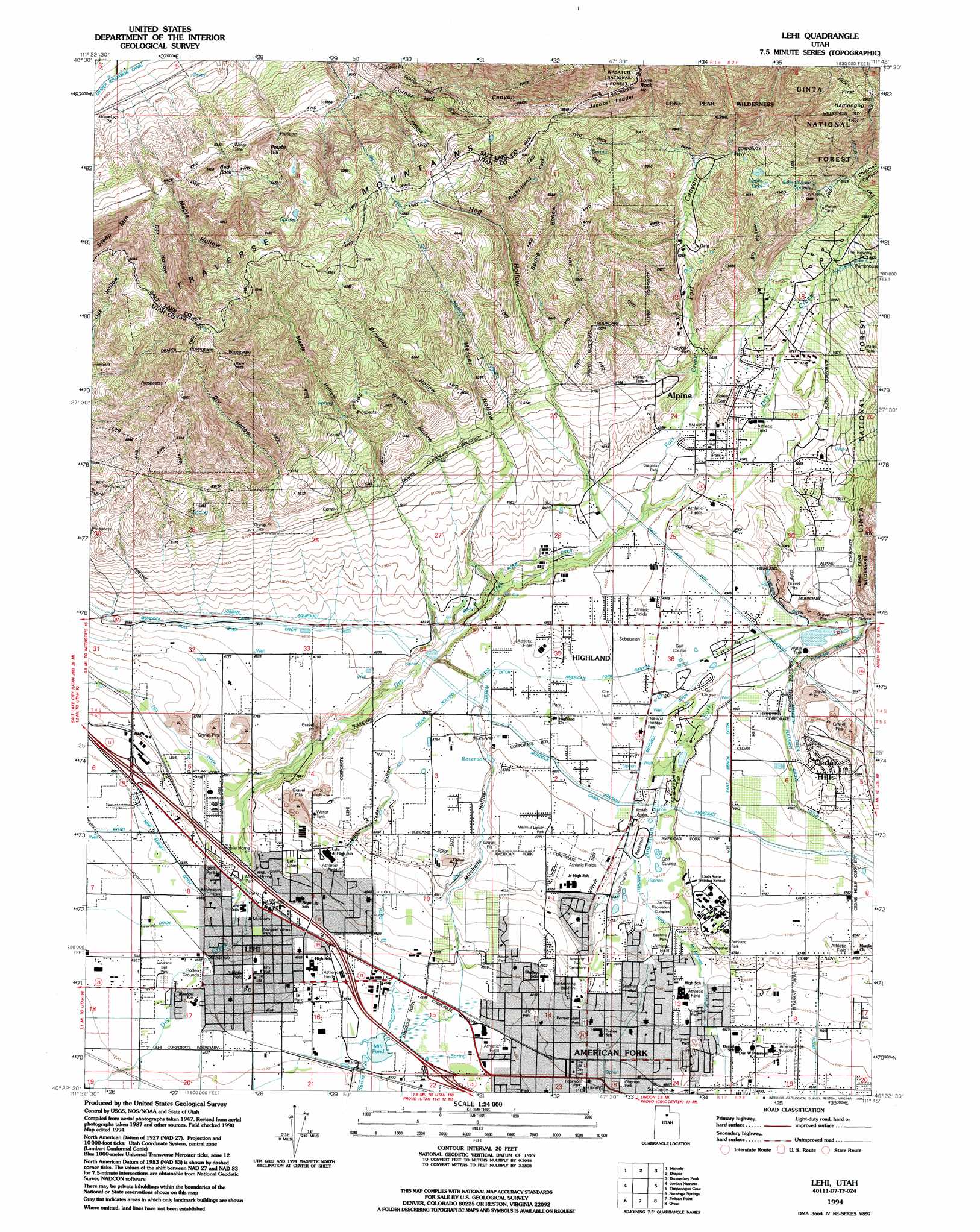
USGS Topo Quad 40111d7 - 1:24,000 scale
| Topo Map Name: | Lehi |
| USGS Topo Quad ID: | 40111d7 |
| Print Size: | ca. 21 1/4" wide x 27" high |
| Southeast Coordinates: | 40.375° N latitude / 111.75° W longitude |
| Map Center Coordinates: | 40.4375° N latitude / 111.8125° W longitude |
| U.S. State: | UT |
| Filename: | o40111d7.jpg |
| Download Map JPG Image: | Lehi topo map 1:24,000 scale |
| Map Type: | Topographic |
| Topo Series: | 7.5´ |
| Map Scale: | 1:24,000 |
| Source of Map Images: | United States Geological Survey (USGS) |
| Alternate Map Versions: |
Lehi UT 1951, updated 1953 Download PDF Buy paper map Lehi UT 1951, updated 1962 Download PDF Buy paper map Lehi UT 1951, updated 1970 Download PDF Buy paper map Lehi UT 1951, updated 1978 Download PDF Buy paper map Lehi UT 1951, updated 1986 Download PDF Buy paper map Lehi UT 1994, updated 1994 Download PDF Buy paper map Lehi UT 1998, updated 2000 Download PDF Buy paper map Lehi UT 2011 Download PDF Buy paper map Lehi UT 2014 Download PDF Buy paper map |
| FStopo: | US Forest Service topo Lehi is available: Download FStopo PDF Download FStopo TIF |
1:24,000 Topo Quads surrounding Lehi
Magna |
Salt Lake City South |
Sugar House |
Mount Aire |
Park City West |
Lark |
Midvale |
Draper |
Dromedary Peak |
Brighton |
Tickville Spring |
Jordan Narrows |
Lehi |
Timpanogos Cave |
Aspen Grove |
Cedar Fort |
Saratoga Springs |
Pelican Point |
Orem |
Bridal Veil Falls |
Goshen Pass |
Soldiers Pass |
Lincoln Point |
Provo |
Springville |
> Back to 40111a1 at 1:100,000 scale
> Back to 40110a1 at 1:250,000 scale
> Back to U.S. Topo Maps home
Lehi topo map: Gazetteer
Lehi: Airports
American Fork Hospital Heliport elevation 1402m 4599′Lehi Airport elevation 1455m 4773′
Lehi: Basins
Utah Valley elevation 1580m 5183′Lehi: Canals
American Fork Canyon Ditch elevation 1488m 4881′Bull River Ditch elevation 1469m 4819′
Cedar Hollow Ditch elevation 1467m 4812′
East Bench Ditch elevation 1487m 4878′
Eighty Rod Ditch elevation 1496m 4908′
Fox Ditch elevation 1420m 4658′
Harmon Ditch elevation 1472m 4829′
McArthur Ditch elevation 1421m 4662′
Merideth Ditch elevation 1508m 4947′
Mitchell Ditch elevation 1440m 4724′
Mitchell Ditch elevation 1489m 4885′
New Survey Ditch elevation 1392m 4566′
Nielson Ditch elevation 1520m 4986′
Pleasant Grove Ditch elevation 1504m 4934′
Salt Lake City Aqueduct elevation 1499m 4917′
Lehi: Crossings
Interchange 281 elevation 1384m 4540′Interchange 282 elevation 1391m 4563′
Interchange 285 elevation 1396m 4580′
Lehi: Lakes
Nephs Lake elevation 1792m 5879′Lehi: Parks
Margaret Wines Park elevation 1393m 4570′Robinson Park elevation 1403m 4603′
Lehi: Populated Places
Alpine elevation 1509m 4950′American Fork elevation 1404m 4606′
Cedar Hills elevation 1511m 4957′
Highland elevation 1518m 4980′
Lehi elevation 1391m 4563′
Lehi: Post Offices
American Fork Post Office elevation 1402m 4599′Lehi Post Office elevation 1388m 4553′
Lehi: Reservoirs
Mill Pond elevation 1379m 4524′Lehi: Slopes
Jacobs Ladder elevation 2055m 6742′Lehi: Springs
Schoolhouse Springs elevation 1747m 5731′Lehi: Streams
Fort Creek elevation 1485m 4872′Lehi: Summits
First Hamongog elevation 2164m 7099′Lone Rock elevation 2112m 6929′
Potato Hill elevation 1708m 5603′
Red Rock elevation 1655m 5429′
Lehi: Valleys
American Fork Canyon elevation 1648m 5406′Big Hollow elevation 1588m 5209′
Box Elder Canyon elevation 1684m 5524′
Broadleaf Hollow elevation 1546m 5072′
Cedar Hollow elevation 1429m 4688′
Chipman Canyon elevation 1708m 5603′
Dry Creek Canyon elevation 1629m 5344′
Dry Hollow elevation 1556m 5104′
Fort Canyon elevation 1518m 4980′
Hog Hollow elevation 1505m 4937′
Maple Hollow elevation 1540m 5052′
Maple Hollow elevation 1426m 4678′
Mercer Hollow elevation 1524m 5000′
Mitchells Hollow elevation 1400m 4593′
Oak Hollow elevation 1430m 4691′
Preston Canyon elevation 1560m 5118′
Right-Hand Fork Hog Hollow elevation 1713m 5620′
Smooth Canyon elevation 1575m 5167′
Spring Hollow elevation 1592m 5223′
Woods Hollow elevation 1549m 5082′
Lehi digital topo map on disk
Buy this Lehi topo map showing relief, roads, GPS coordinates and other geographical features, as a high-resolution digital map file on DVD: