Soapstone Basin Topo Map Utah
To zoom in, hover over the map of Soapstone Basin
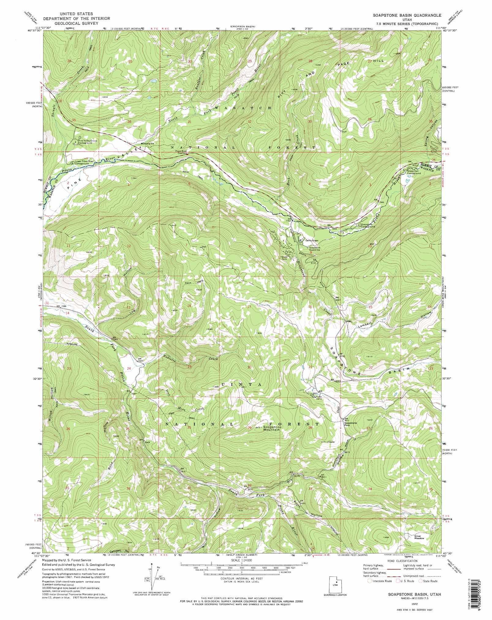
USGS Topo Quad 40111e1 - 1:24,000 scale
| Topo Map Name: | Soapstone Basin |
| USGS Topo Quad ID: | 40111e1 |
| Print Size: | ca. 21 1/4" wide x 27" high |
| Southeast Coordinates: | 40.5° N latitude / 111° W longitude |
| Map Center Coordinates: | 40.5625° N latitude / 111.0625° W longitude |
| U.S. State: | UT |
| Filename: | o40111e1.jpg |
| Download Map JPG Image: | Soapstone Basin topo map 1:24,000 scale |
| Map Type: | Topographic |
| Topo Series: | 7.5´ |
| Map Scale: | 1:24,000 |
| Source of Map Images: | United States Geological Survey (USGS) |
| Alternate Map Versions: |
Soapstone Basin UT 1972, updated 1974 Download PDF Buy paper map Soapstone Basin UT 1972, updated 1974 Download PDF Buy paper map Soapstone Basin UT 1998, updated 2001 Download PDF Buy paper map Soapstone Basin UT 2011 Download PDF Buy paper map Soapstone Basin UT 2014 Download PDF Buy paper map |
| FStopo: | US Forest Service topo Soapstone Basin is available: Download FStopo PDF Download FStopo TIF |
1:24,000 Topo Quads surrounding Soapstone Basin
Crandall Canyon |
Hidden Lake |
Slader Basin |
Whitney Reservoir |
Christmas Meadows |
Kamas |
Hoyt Peak |
Erickson Basin |
Mirror Lake |
Hayden Peak |
Francis |
Woodland |
Soapstone Basin |
Iron Mine Mountain |
Grandaddy Lake |
Center Creek |
Heber Mountain |
Wolf Creek Summit |
Wolf Creek |
Hanna |
Twin Peaks |
Co-Op Creek |
Jimmies Point |
Raspberry Knoll |
Tabby Mountain |
> Back to 40111e1 at 1:100,000 scale
> Back to 40110a1 at 1:250,000 scale
> Back to U.S. Topo Maps home
Soapstone Basin topo map: Gazetteer
Soapstone Basin: Basins
Soapstone Basin elevation 2628m 8622′Soapstone Basin: Flats
Silver Meadow elevation 2871m 9419′Soapstone Basin: Gaps
Soapstone Pass elevation 2766m 9074′Soapstone Basin: Parks
YMCA Camp elevation 2492m 8175′Soapstone Basin: Populated Places
Soapstone Summer Home Area elevation 2407m 7896′Soapstone Basin: Streams
Boulder Creek elevation 2340m 7677′Iron Mine Creek elevation 2324m 7624′
Nobletts Creek elevation 2249m 7378′
North Fork Provo River elevation 2268m 7440′
Rock Creek elevation 2339m 7673′
Shingle Creek elevation 2245m 7365′
Soapstone Creek elevation 2366m 7762′
Soapstone Basin: Summits
Pitt and Page Hill elevation 3118m 10229′Soapstone Mountain elevation 2886m 9468′
Soapstone Basin: Trails
Littles Fork Trail elevation 2309m 7575′Nobletts Creek Trail elevation 2757m 9045′
Soapstone Basin: Tunnels
West Portal Duchesne Tunnel elevation 2564m 8412′Soapstone Basin: Valleys
Bone Hollow elevation 2315m 7595′Dry Hollow elevation 2435m 7988′
Lambert Hollow elevation 2557m 8389′
Log Hollow elevation 2240m 7349′
Mill Hollow elevation 2404m 7887′
Potts Hollow elevation 2494m 8182′
Spring Canyon elevation 2486m 8156′
Soapstone Basin digital topo map on disk
Buy this Soapstone Basin topo map showing relief, roads, GPS coordinates and other geographical features, as a high-resolution digital map file on DVD: