Woodland Topo Map Utah
To zoom in, hover over the map of Woodland
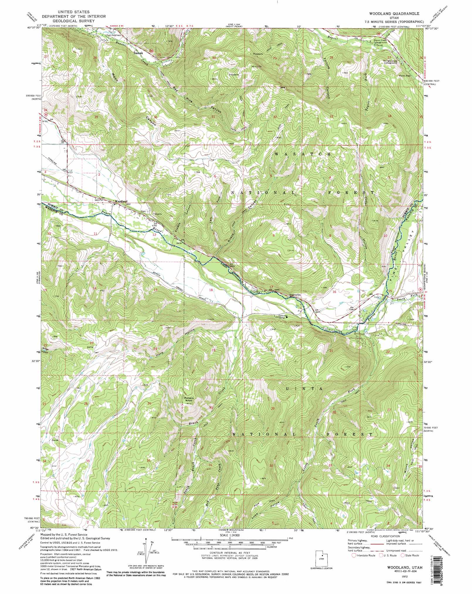
USGS Topo Quad 40111e2 - 1:24,000 scale
| Topo Map Name: | Woodland |
| USGS Topo Quad ID: | 40111e2 |
| Print Size: | ca. 21 1/4" wide x 27" high |
| Southeast Coordinates: | 40.5° N latitude / 111.125° W longitude |
| Map Center Coordinates: | 40.5625° N latitude / 111.1875° W longitude |
| U.S. State: | UT |
| Filename: | o40111e2.jpg |
| Download Map JPG Image: | Woodland topo map 1:24,000 scale |
| Map Type: | Topographic |
| Topo Series: | 7.5´ |
| Map Scale: | 1:24,000 |
| Source of Map Images: | United States Geological Survey (USGS) |
| Alternate Map Versions: |
Woodland UT 1972, updated 1974 Download PDF Buy paper map Woodland UT 1972, updated 1985 Download PDF Buy paper map Woodland UT 1972, updated 1986 Download PDF Buy paper map Woodland UT 1998, updated 2001 Download PDF Buy paper map Woodland UT 2011 Download PDF Buy paper map Woodland UT 2014 Download PDF Buy paper map |
| FStopo: | US Forest Service topo Woodland is available: Download FStopo PDF Download FStopo TIF |
1:24,000 Topo Quads surrounding Woodland
Wanship |
Crandall Canyon |
Hidden Lake |
Slader Basin |
Whitney Reservoir |
Park City East |
Kamas |
Hoyt Peak |
Erickson Basin |
Mirror Lake |
Heber City |
Francis |
Woodland |
Soapstone Basin |
Iron Mine Mountain |
Charleston |
Center Creek |
Heber Mountain |
Wolf Creek Summit |
Wolf Creek |
Wallsburg Ridge |
Twin Peaks |
Co-Op Creek |
Jimmies Point |
Raspberry Knoll |
> Back to 40111e1 at 1:100,000 scale
> Back to 40110a1 at 1:250,000 scale
> Back to U.S. Topo Maps home
Woodland topo map: Gazetteer
Woodland: Parks
Shingle Creek Recreation Site elevation 2289m 7509′Woodland: Populated Places
Samak elevation 2090m 6856′Woodland elevation 2049m 6722′
Woodland: Streams
Bench Creek elevation 2086m 6843′Coop Creek elevation 2241m 7352′
Left Fork Beaver Creek elevation 2054m 6738′
Little South Fork Provo River elevation 2154m 7066′
Red Pine Creek elevation 2335m 7660′
South Bench Creek elevation 2288m 7506′
South Fork Provo River elevation 2171m 7122′
Talyor Fork elevation 2252m 7388′
Willow Creek elevation 2690m 8825′
Woodland: Summits
Potters Knoll elevation 2517m 8257′Woodland: Valleys
Buck Hollow elevation 2398m 7867′Camp Hollow elevation 2332m 7650′
Cedar Hollow elevation 2231m 7319′
Failure Canyon elevation 2213m 7260′
Herd Hollow elevation 2167m 7109′
Left Fork Rileys Canyon elevation 2121m 6958′
Moon Canyon elevation 2064m 6771′
Pine Valley elevation 2168m 7112′
Red Pine Canyon elevation 2092m 6863′
Rileys Canyon elevation 2095m 6873′
Svedes Canyon elevation 2080m 6824′
Willow Hollow elevation 2236m 7335′
Woodland digital topo map on disk
Buy this Woodland topo map showing relief, roads, GPS coordinates and other geographical features, as a high-resolution digital map file on DVD: