Hoyt Peak Topo Map Utah
To zoom in, hover over the map of Hoyt Peak
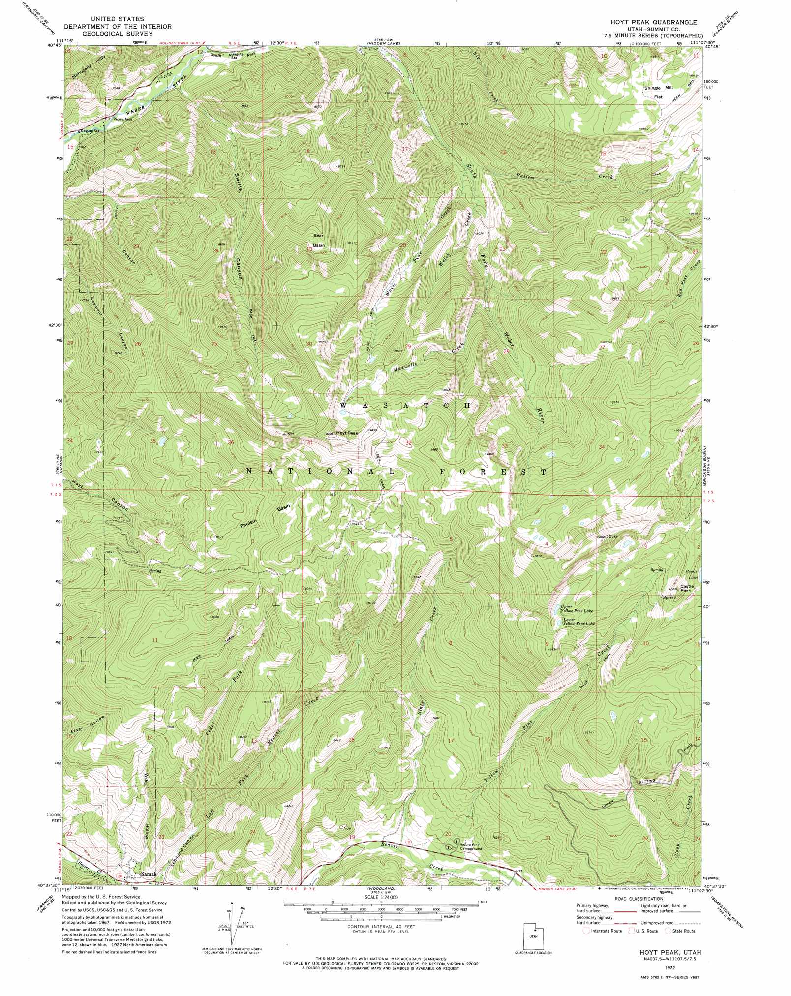
USGS Topo Quad 40111f2 - 1:24,000 scale
| Topo Map Name: | Hoyt Peak |
| USGS Topo Quad ID: | 40111f2 |
| Print Size: | ca. 21 1/4" wide x 27" high |
| Southeast Coordinates: | 40.625° N latitude / 111.125° W longitude |
| Map Center Coordinates: | 40.6875° N latitude / 111.1875° W longitude |
| U.S. State: | UT |
| Filename: | o40111f2.jpg |
| Download Map JPG Image: | Hoyt Peak topo map 1:24,000 scale |
| Map Type: | Topographic |
| Topo Series: | 7.5´ |
| Map Scale: | 1:24,000 |
| Source of Map Images: | United States Geological Survey (USGS) |
| Alternate Map Versions: |
Hoyt Peak UT 1972, updated 1974 Download PDF Buy paper map Hoyt Peak UT 1972, updated 1983 Download PDF Buy paper map Hoyt Peak UT 1972, updated 1983 Download PDF Buy paper map Hoyt Peak UT 1998, updated 2001 Download PDF Buy paper map Hoyt Peak UT 2011 Download PDF Buy paper map Hoyt Peak UT 2014 Download PDF Buy paper map |
| FStopo: | US Forest Service topo Hoyt Peak is available: Download FStopo PDF Download FStopo TIF |
1:24,000 Topo Quads surrounding Hoyt Peak
Coalville |
Turner Hollow |
Upton |
Red Hole |
Seven Tree Flat |
Wanship |
Crandall Canyon |
Hidden Lake |
Slader Basin |
Whitney Reservoir |
Park City East |
Kamas |
Hoyt Peak |
Erickson Basin |
Mirror Lake |
Heber City |
Francis |
Woodland |
Soapstone Basin |
Iron Mine Mountain |
Charleston |
Center Creek |
Heber Mountain |
Wolf Creek Summit |
Wolf Creek |
> Back to 40111e1 at 1:100,000 scale
> Back to 40110a1 at 1:250,000 scale
> Back to U.S. Topo Maps home
Hoyt Peak topo map: Gazetteer
Hoyt Peak: Basins
Bear Basin elevation 2706m 8877′Paulsin Basin elevation 2661m 8730′
Hoyt Peak: Flats
Shingle Mill Flat elevation 3002m 9849′Hoyt Peak: Lakes
Castle Lake elevation 3010m 9875′Lower Yellow Pine Lake elevation 2933m 9622′
Upper Yellow Pine Lake elevation 2959m 9708′
Hoyt Peak: Parks
Kamas Wildlife Management Area elevation 2303m 7555′Weber Cottonwood Recreation Site elevation 2041m 6696′
Hoyt Peak: Streams
Cedar Fork elevation 2102m 6896′Maxwells Creek elevation 2438m 7998′
Nobletts Creek elevation 2159m 7083′
Pullem Creek elevation 2270m 7447′
Slate Creek elevation 2147m 7043′
South Fork Weber River elevation 2108m 6916′
Welch Creek elevation 2311m 7582′
White Pine Creek elevation 2271m 7450′
Yellow Pine Creek elevation 2159m 7083′
Hoyt Peak: Summits
Castle Peak elevation 3099m 10167′Hoyt Peak elevation 3120m 10236′
Hoyt Peak: Valleys
Left-hand Canyon elevation 2063m 6768′Swifts Canyon elevation 2074m 6804′
Wide Hollow elevation 2072m 6797′
Hoyt Peak digital topo map on disk
Buy this Hoyt Peak topo map showing relief, roads, GPS coordinates and other geographical features, as a high-resolution digital map file on DVD: