Hidden Lake Topo Map Utah
To zoom in, hover over the map of Hidden Lake
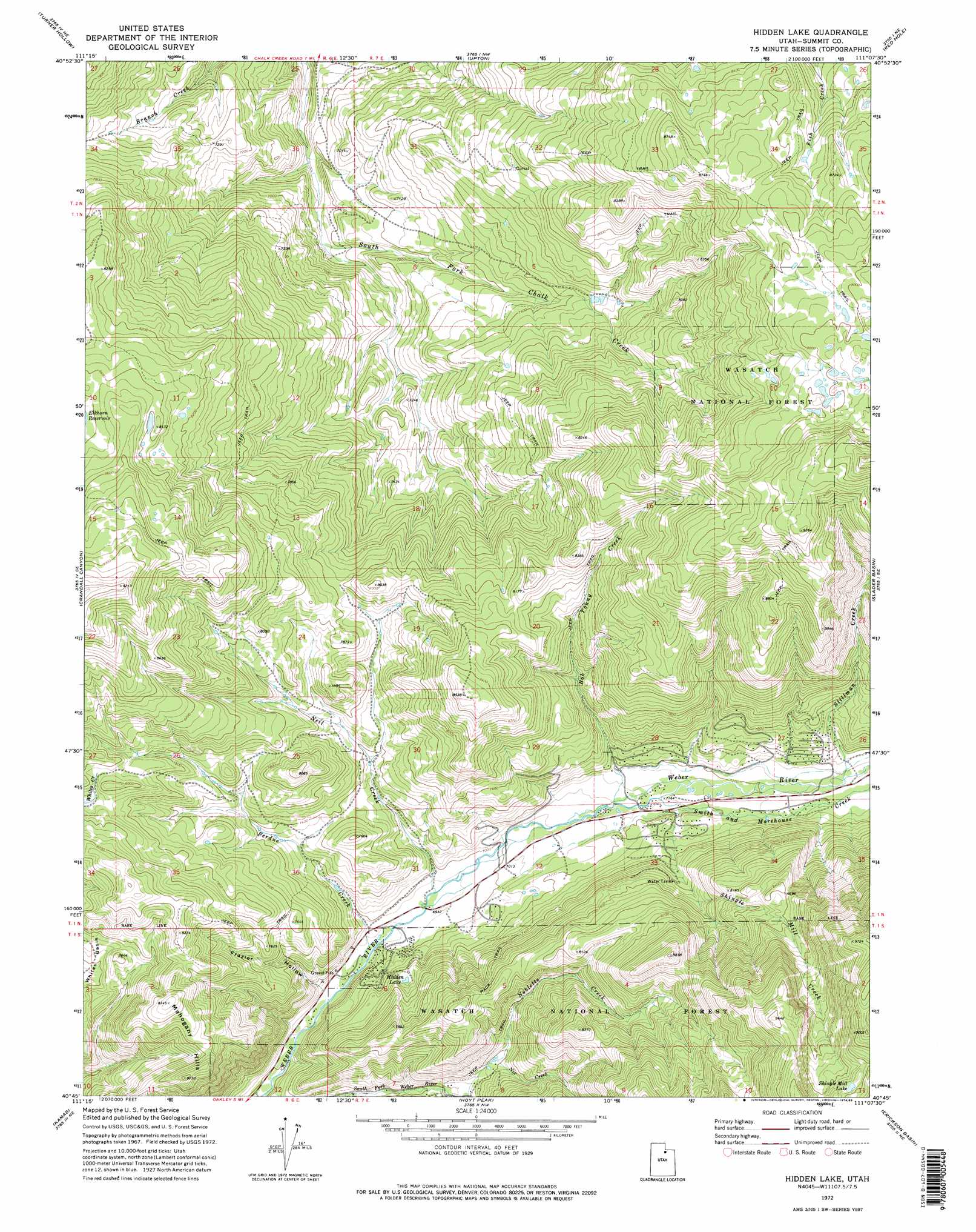
USGS Topo Quad 40111g2 - 1:24,000 scale
| Topo Map Name: | Hidden Lake |
| USGS Topo Quad ID: | 40111g2 |
| Print Size: | ca. 21 1/4" wide x 27" high |
| Southeast Coordinates: | 40.75° N latitude / 111.125° W longitude |
| Map Center Coordinates: | 40.8125° N latitude / 111.1875° W longitude |
| U.S. State: | UT |
| Filename: | o40111g2.jpg |
| Download Map JPG Image: | Hidden Lake topo map 1:24,000 scale |
| Map Type: | Topographic |
| Topo Series: | 7.5´ |
| Map Scale: | 1:24,000 |
| Source of Map Images: | United States Geological Survey (USGS) |
| Alternate Map Versions: |
Hidden Lake UT 1972, updated 1974 Download PDF Buy paper map Hidden Lake UT 1972, updated 1985 Download PDF Buy paper map Hidden Lake UT 1972, updated 1985 Download PDF Buy paper map Hidden Lake UT 1998, updated 2001 Download PDF Buy paper map Hidden Lake UT 2011 Download PDF Buy paper map Hidden Lake UT 2014 Download PDF Buy paper map |
| FStopo: | US Forest Service topo Hidden Lake is available: Download FStopo PDF Download FStopo TIF |
1:24,000 Topo Quads surrounding Hidden Lake
Henefer |
Heiners Creek |
Castle Rock |
Porcupine Ridge |
Myers Reservoir |
Coalville |
Turner Hollow |
Upton |
Red Hole |
Seven Tree Flat |
Wanship |
Crandall Canyon |
Hidden Lake |
Slader Basin |
Whitney Reservoir |
Park City East |
Kamas |
Hoyt Peak |
Erickson Basin |
Mirror Lake |
Heber City |
Francis |
Woodland |
Soapstone Basin |
Iron Mine Mountain |
> Back to 40111e1 at 1:100,000 scale
> Back to 40110a1 at 1:250,000 scale
> Back to U.S. Topo Maps home
Hidden Lake topo map: Gazetteer
Hidden Lake: Basins
Whites Basin elevation 2317m 7601′Hidden Lake: Lakes
Hidden Lake elevation 2205m 7234′Shingle Mill Lake elevation 2911m 9550′
Hidden Lake: Ridges
Mahogany Hills elevation 2507m 8225′Hidden Lake: Streams
Bob Young Creek elevation 2160m 7086′Neil Creek elevation 2119m 6952′
Nix Creek elevation 2194m 7198′
Perdue Creek elevation 2108m 6916′
Shingle Mill Creek elevation 2193m 7194′
Smith and Morehouse Creek elevation 2152m 7060′
Stillman Creek elevation 2218m 7276′
Hidden Lake: Valleys
Frazier Hollow elevation 2098m 6883′Hidden Lake: Woods
The Pines elevation 2302m 7552′Hidden Lake digital topo map on disk
Buy this Hidden Lake topo map showing relief, roads, GPS coordinates and other geographical features, as a high-resolution digital map file on DVD: