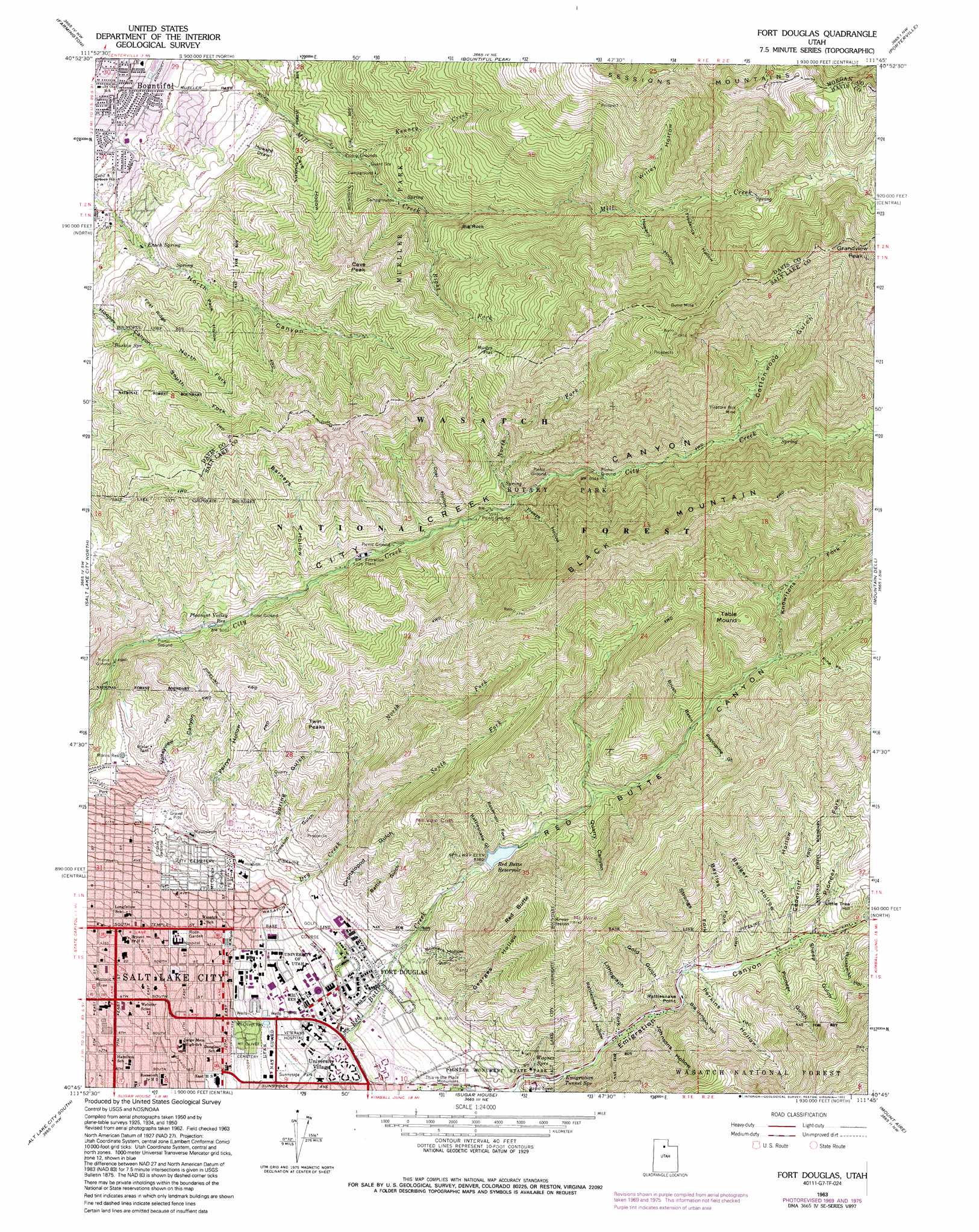
Fort Douglas Topo Map Utah
To zoom in, hover over the map of Fort Douglas
USGS Topo Quad 40111g7 - 1:24,000 scale
| Topo Map Name: | Fort Douglas |
| USGS Topo Quad ID: | 40111g7 |
| Print Size: | ca. 21 1/4" wide x 27" high |
| Southeast Coordinates: | 40.75° N latitude / 111.75° W longitude |
| Map Center Coordinates: | 40.8125° N latitude / 111.8125° W longitude |
| U.S. State: | UT |
| Filename: | o40111g7.jpg |
| Download Map JPG Image: | Fort Douglas topo map 1:24,000 scale |
| Map Type: | Topographic |
| Topo Series: | 7.5´ |
| Map Scale: | 1:24,000 |
| Source of Map Images: | United States Geological Survey (USGS) |
| Alternate Map Versions: |
Fort Douglas UT 1950, updated 1958 Download PDF Buy paper map Fort Douglas UT 1951 Download PDF Buy paper map Fort Douglas UT 1963, updated 1964 Download PDF Buy paper map Fort Douglas UT 1963, updated 1970 Download PDF Buy paper map Fort Douglas UT 1963, updated 1978 Download PDF Buy paper map Fort Douglas UT 1963, updated 1984 Download PDF Buy paper map Fort Douglas UT 1963, updated 1993 Download PDF Buy paper map Fort Douglas UT 1998, updated 2001 Download PDF Buy paper map Fort Douglas UT 2011 Download PDF Buy paper map Fort Douglas UT 2014 Download PDF Buy paper map |
| FStopo: | US Forest Service topo Fort Douglas is available: Download FStopo PDF Download FStopo TIF |
1:24,000 Topo Quads surrounding Fort Douglas
Clearfield |
Kaysville |
Peterson |
Morgan |
Devils Slide |
Saltair Ne |
Farmington |
Bountiful Peak |
Porterville |
East Canyon Reservoir |
Saltair |
Salt Lake City North |
Fort Douglas |
Mountain Dell |
Big Dutch Hollow |
Magna |
Salt Lake City South |
Sugar House |
Mount Aire |
Park City West |
Lark |
Midvale |
Draper |
Dromedary Peak |
Brighton |
> Back to 40111e1 at 1:100,000 scale
> Back to 40110a1 at 1:250,000 scale
> Back to U.S. Topo Maps home
Fort Douglas topo map: Gazetteer
Fort Douglas: Airports
Holy Cross Hospital Helipad elevation 1362m 4468′United States Forest Service Airport elevation 1414m 4639′
University of Utah Medical Center Heliport elevation 1509m 4950′
Veterans Administration Hospital Heliport elevation 1456m 4776′
Fort Douglas: Bridges
George S Eccless 2002 Legacy Bridge elevation 1471m 4826′Fort Douglas: Cliffs
Rattlesnake Point elevation 1615m 5298′Fort Douglas: Dams
Red Butte Dam elevation 1661m 5449′Fort Douglas: Mines
Burro Mine elevation 2618m 8589′Treasure Box Mine elevation 2046m 6712′
Fort Douglas: Parks
Lindsey Gardens elevation 1444m 4737′Mueller Park Recreation Site elevation 1641m 5383′
Muller Park elevation 1793m 5882′
Pioneer Monument State Park elevation 1528m 5013′
Red Butte Canyon Research Natural Area elevation 1991m 6532′
Rice-Eccles Stadium elevation 1412m 4632′
Rose Garden elevation 1371m 4498′
Rotary Park elevation 1912m 6272′
Sunnyside Park elevation 1426m 4678′
This is the Place Monument elevation 1500m 4921′
Fort Douglas: Populated Places
Arlington Hills elevation 1562m 5124′Arlington Park elevation 1532m 5026′
Bonneville on the Hill elevation 1455m 4773′
Bonneville Tower Condominium elevation 1351m 4432′
Browns Park elevation 1536m 5039′
Cambridge Condominium elevation 1348m 4422′
Capitol Heights elevation 1537m 5042′
Capitol Hill elevation 1504m 4934′
Casa de Norte elevation 1494m 4901′
Chelsea Cove elevation 1571m 5154′
Cobble Knoll Condominium elevation 1342m 4402′
Cookes elevation 1400m 4593′
Country Hills elevation 1403m 4603′
Dorius Building Condominium elevation 1348m 4422′
Dunfords elevation 1478m 4849′
Ellison Place elevation 1517m 4977′
Emerald Hills elevation 1449m 4753′
Emigration Oaks elevation 1713m 5620′
Emigration Passive Solar Home Condominium elevation 1677m 5501′
Empress Condominium elevation 1451m 4760′
Federal-Heights elevation 1484m 4868′
Fort Douglas elevation 1493m 4898′
Fraternity Park elevation 1495m 4904′
Golf Course Estates elevation 1549m 5082′
Grand View elevation 1417m 4648′
Grand View elevation 1436m 4711′
Halls Fifth Avenue Condominium elevation 1391m 4563′
High Pointe elevation 1582m 5190′
Indian Springs Estates elevation 1567m 5141′
Lindsey Circle Condominium elevation 1448m 4750′
Maple Cove elevation 1708m 5603′
Maple Hills elevation 1563m 5127′
Maple Springs elevation 1458m 4783′
Mayflower Condominium elevation 1398m 4586′
Mid Avenues Condominium elevation 1387m 4550′
Mill Creek Heights elevation 1444m 4737′
Mon de Ville Condominium elevation 1347m 4419′
Mueller Heights elevation 1396m 4580′
Nelson elevation 1393m 4570′
New England Condominium elevation 1353m 4438′
Newport Heights elevation 1571m 5154′
Nobhill elevation 1422m 4665′
North Bonneville elevation 1590m 5216′
North Canyon Estates elevation 1589m 5213′
North Hills elevation 1552m 5091′
Northcrest elevation 1565m 5134′
Northridge Heights Condominium elevation 1379m 4524′
Oak Hills elevation 1418m 4652′
Oak Way elevation 1384m 4540′
Oakcrest elevation 1569m 5147′
Oakhaven Park elevation 1407m 4616′
Oakhaven Village elevation 1387m 4550′
Oakridge Manor elevation 1509m 4950′
Oakvista Park elevation 1474m 4835′
Orchard Park elevation 1386m 4547′
Panorama Acres elevation 1430m 4691′
Paradise Hills elevation 1414m 4639′
Perrys Hollow elevation 1578m 5177′
Pioneer Addition elevation 1631m 5351′
Popperton Place elevation 1424m 4671′
Pratts elevation 1420m 4658′
Quad elevation 1664m 5459′
Ridgewood of Maple Hills Condominiums elevation 1581m 5187′
San Simeon Hills elevation 1476m 4842′
Somerset Garden Condominium elevation 1396m 4580′
Spring Glen elevation 1623m 5324′
Sunset Hollow elevation 1641m 5383′
The Avenues Condominium elevation 1368m 4488′
The Avenues Hertiage Condominium elevation 1357m 4452′
The Maryland Condominium elevation 1352m 4435′
The Wilshire Condo elevation 1343m 4406′
Third and M Townhouse Condominium elevation 1375m 4511′
Thirteenth Avenue elevation 1494m 4901′
University Village elevation 1442m 4730′
Victoria Place elevation 1417m 4648′
Victorian Condominium elevation 1369m 4491′
Virginia Heights elevation 1484m 4868′
Woodmansee elevation 1317m 4320′
Fort Douglas: Post Offices
Foothill Station Post Office elevation 1467m 4812′Fort Douglas: Ranges
Sessions Mountains elevation 2804m 9199′Fort Douglas: Reservoirs
Morris Reservoir elevation 1576m 5170′Mount Olivet Reservoir elevation 1419m 4655′
Pleasant Valley Reservoir elevation 1535m 5036′
Red Butte Reservoir elevation 1641m 5383′
Fort Douglas: Ridges
First Ridge elevation 1769m 5803′Fort Douglas: Springs
Baskin Spring elevation 1681m 5515′Emigration Tunnel Spring elevation 1545m 5068′
Enoch Spring elevation 1562m 5124′
Indian Spring elevation 1608m 5275′
North Spring elevation 1849m 6066′
Wagner Spring elevation 1557m 5108′
Fort Douglas: Streams
Bayliss Fork elevation 1608m 5275′Dry Creek elevation 1480m 4855′
Kenney Creek elevation 1627m 5337′
Lithograph Fork elevation 1556m 5104′
North Fork City Creek elevation 1741m 5711′
North Fork Dry Creek elevation 1586m 5203′
Parleys Fork Red Butte Creek elevation 1717m 5633′
Pine Fork elevation 1982m 6502′
Pioneer Fork elevation 1642m 5387′
Reservoir Fork elevation 1646m 5400′
Right Fork Mill Creek elevation 1801m 5908′
South Fork Dry Creek elevation 1583m 5193′
Strongs Fork elevation 1600m 5249′
Fort Douglas: Summits
Big Rock elevation 1890m 6200′Black Mountain elevation 2483m 8146′
Cave Peak elevation 2076m 6811′
Grandview Peak elevation 2866m 9402′
Little Tree Hill elevation 1762m 5780′
Mount Van Cott elevation 1921m 6302′
Mount Wire elevation 2166m 7106′
Red Butte elevation 2011m 6597′
Rudys Flat elevation 2184m 7165′
Table Mound elevation 2195m 7201′
Twin Peaks elevation 1904m 6246′
Fort Douglas: Valleys
Badger Hollow elevation 1633m 5357′Barneys Hollow elevation 1592m 5223′
Battle Gulch elevation 1576m 5170′
Big Jensen Hollow elevation 1586m 5203′
Blacksmith Hollow elevation 1651m 5416′
Brush Basin elevation 1836m 6023′
Cave Hollow elevation 1563m 5127′
Cederloff Hollow elevation 1637m 5370′
Cephalopod Gulch elevation 1542m 5059′
Coal Hollow elevation 1693m 5554′
Cottonwood Gulch elevation 1984m 6509′
Elk Hollow elevation 2002m 6568′
Emigration Canyon elevation 1503m 4931′
Frederick Hollow elevation 2161m 7089′
Freeze Hollow elevation 1750m 5741′
Georges Hollow elevation 1561m 5121′
Gold Gulch elevation 1584m 5196′
Howard Draw elevation 1589m 5213′
Howard Hollow elevation 2099m 6886′
Johnsons Hollow elevation 1569m 5147′
Knowltons Fork elevation 1916m 6286′
Limekiln Gulch elevation 1464m 4803′
North Fork Hooper Canyon elevation 1692m 5551′
Pace Hollow elevation 1657m 5436′
Perkins Hollow elevation 1606m 5269′
Perrys Hollow elevation 1496m 4908′
Pioneer Gulch elevation 1621m 5318′
Quarry Canyon elevation 1707m 5600′
Rattlesnake Gulch elevation 1641m 5383′
Rattlesnake Hollow elevation 1553m 5095′
Red Butte Canyon elevation 1513m 4963′
Sheep Gulch elevation 1632m 5354′
Soldiers Hollow elevation 1547m 5075′
South Fork Hooper Canyon elevation 1696m 5564′
Spring Gulch elevation 1503m 4931′
Valleyview Canyon elevation 1585m 5200′
Willey Hollow elevation 2075m 6807′
Fort Douglas digital topo map on disk
Buy this Fort Douglas topo map showing relief, roads, GPS coordinates and other geographical features, as a high-resolution digital map file on DVD: