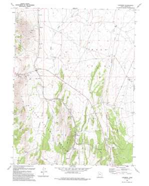
Lofgreen Topo Map Utah
To zoom in, hover over the map of Lofgreen
USGS Topo Quad 40112a3 - 1:24,000 scale
| Topo Map Name: | Lofgreen |
| USGS Topo Quad ID: | 40112a3 |
| Print Size: | ca. 21 1/4" wide x 27" high |
| Southeast Coordinates: | 40° N latitude / 112.25° W longitude |
| Map Center Coordinates: | 40.0625° N latitude / 112.3125° W longitude |
| U.S. State: | UT |
| Filename: | o40112a3.jpg |
| Download Map JPG Image: | Lofgreen topo map 1:24,000 scale |
| Map Type: | Topographic |
| Topo Series: | 7.5´ |
| Map Scale: | 1:24,000 |
| Source of Map Images: | United States Geological Survey (USGS) |
| Alternate Map Versions: |
Lofgreen UT 1971, updated 1974 Download PDF Buy paper map Lofgreen UT 1993, updated 1993 Download PDF Buy paper map Lofgreen UT 1998, updated 2002 Download PDF Buy paper map Lofgreen UT 2011 Download PDF Buy paper map Lofgreen UT 2014 Download PDF Buy paper map |
| FStopo: | US Forest Service topo Lofgreen is available: Download FStopo PDF Download FStopo TIF |
1:24,000 Topo Quads surrounding Lofgreen
> Back to 40112a1 at 1:100,000 scale
> Back to 40112a1 at 1:250,000 scale
> Back to U.S. Topo Maps home
Lofgreen topo map: Gazetteer
Lofgreen: Populated Places
Lofgreen elevation 1766m 5793′Pehrson elevation 1681m 5515′
Lofgreen: Streams
Brush Creek elevation 1665m 5462′Dog Hollow Creek elevation 1723m 5652′
Lofgreen: Valleys
Sharpes Valley elevation 1666m 5465′Lofgreen: Wells
Cummings Well elevation 1678m 5505′Scranton Well elevation 1662m 5452′
Lofgreen digital topo map on disk
Buy this Lofgreen topo map showing relief, roads, GPS coordinates and other geographical features, as a high-resolution digital map file on DVD:


