North Willow Canyon Topo Map Utah
To zoom in, hover over the map of North Willow Canyon
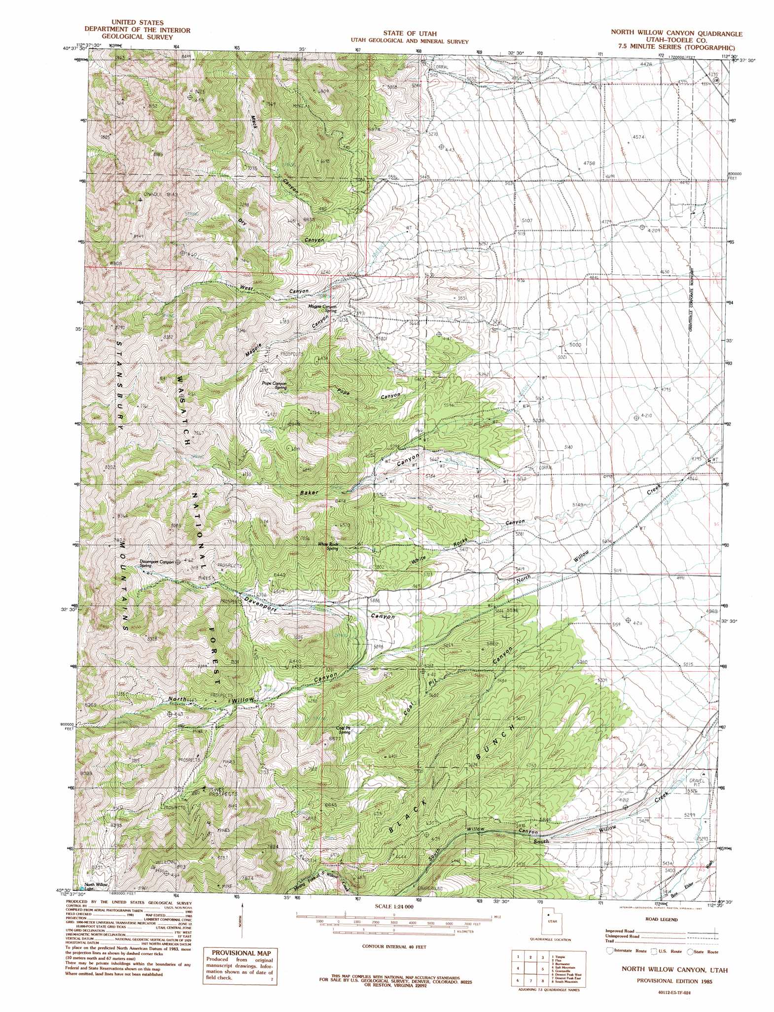
USGS Topo Quad 40112e5 - 1:24,000 scale
| Topo Map Name: | North Willow Canyon |
| USGS Topo Quad ID: | 40112e5 |
| Print Size: | ca. 21 1/4" wide x 27" high |
| Southeast Coordinates: | 40.5° N latitude / 112.5° W longitude |
| Map Center Coordinates: | 40.5625° N latitude / 112.5625° W longitude |
| U.S. State: | UT |
| Filename: | o40112e5.jpg |
| Download Map JPG Image: | North Willow Canyon topo map 1:24,000 scale |
| Map Type: | Topographic |
| Topo Series: | 7.5´ |
| Map Scale: | 1:24,000 |
| Source of Map Images: | United States Geological Survey (USGS) |
| Alternate Map Versions: |
North Willow Canyon UT 1985, updated 1985 Download PDF Buy paper map North Willow Canyon UT 1985, updated 1985 Download PDF Buy paper map North Willow Canyon UT 1998, updated 2001 Download PDF Buy paper map North Willow Canyon UT 2011 Download PDF Buy paper map North Willow Canyon UT 2014 Download PDF Buy paper map |
| FStopo: | US Forest Service topo North Willow Canyon is available: Download FStopo PDF Download FStopo TIF |
1:24,000 Topo Quads surrounding North Willow Canyon
Delle |
Poverty Point |
Corral Canyon |
Plug Peak |
Plug Peak Se |
Hastings Pass Ne |
Timpie |
Flux |
Burmester |
Mills Junction |
Hastings Pass Se |
Salt Mountain |
North Willow Canyon |
Grantsville |
Tooele |
Hickman Knolls |
Deseret Peak West |
Deseret Peak East |
South Mountain |
Stockton |
Tabbys Peak Se |
Terra |
Johnson Pass |
Saint John |
Ophir |
> Back to 40112e1 at 1:100,000 scale
> Back to 40112a1 at 1:250,000 scale
> Back to U.S. Topo Maps home
North Willow Canyon topo map: Gazetteer
North Willow Canyon: Areas
Black Bunch elevation 1739m 5705′North Willow Canyon: Mines
Dragon Mine elevation 2013m 6604′Metal Queen Mine elevation 2463m 8080′
Monarch Mine elevation 2054m 6738′
Rose Mine elevation 2061m 6761′
Third Term Mine elevation 2538m 8326′
Western Star Mine elevation 1989m 6525′
North Willow Canyon: Springs
Black Buck Spring elevation 1981m 6499′Black Bunch Spring elevation 1986m 6515′
Coal Pit Spring elevation 1855m 6085′
Davenport Canyon Spring elevation 2187m 7175′
Limekiln Spring elevation 1751m 5744′
Magpie Canyon Spring elevation 1844m 6049′
Pope Canyon Spring elevation 1939m 6361′
White Rock Spring elevation 1851m 6072′
North Willow Canyon: Trails
Mack Canyon Big Hollow Trail elevation 2093m 6866′North Willow Canyon: Valleys
Baker Canyon elevation 1562m 5124′Coal Pit Canyon elevation 1577m 5173′
Davenport Canyon elevation 1694m 5557′
Dry Canyon elevation 1598m 5242′
Mack Canyon elevation 1765m 5790′
Magpie Canyon elevation 1650m 5413′
North Willow Canyon elevation 1609m 5278′
Pope Canyon elevation 1506m 4940′
West Canyon elevation 1639m 5377′
White Rocks Canyon elevation 1544m 5065′
North Willow Canyon digital topo map on disk
Buy this North Willow Canyon topo map showing relief, roads, GPS coordinates and other geographical features, as a high-resolution digital map file on DVD: