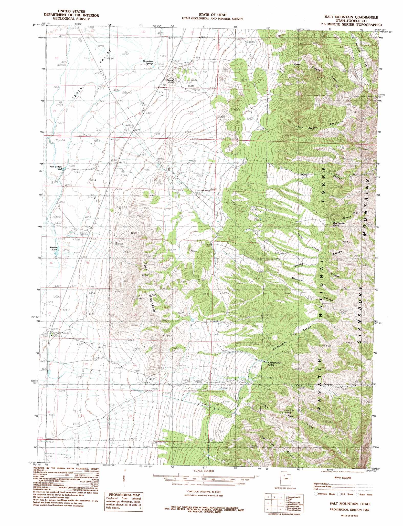
Salt Mountain Topo Map Utah
To zoom in, hover over the map of Salt Mountain
USGS Topo Quad 40112e6 - 1:24,000 scale
| Topo Map Name: | Salt Mountain |
| USGS Topo Quad ID: | 40112e6 |
| Print Size: | ca. 21 1/4" wide x 27" high |
| Southeast Coordinates: | 40.5° N latitude / 112.625° W longitude |
| Map Center Coordinates: | 40.5625° N latitude / 112.6875° W longitude |
| U.S. State: | UT |
| Filename: | o40112e6.jpg |
| Download Map JPG Image: | Salt Mountain topo map 1:24,000 scale |
| Map Type: | Topographic |
| Topo Series: | 7.5´ |
| Map Scale: | 1:24,000 |
| Source of Map Images: | United States Geological Survey (USGS) |
| Alternate Map Versions: |
Salt Mountain UT 1985, updated 1985 Download PDF Buy paper map Salt Mountain UT 1998, updated 2001 Download PDF Buy paper map Salt Mountain UT 2011 Download PDF Buy paper map Salt Mountain UT 2014 Download PDF Buy paper map |
| FStopo: | US Forest Service topo Salt Mountain is available: Download FStopo PDF Download FStopo TIF |
1:24,000 Topo Quads surrounding Salt Mountain
Low |
Delle |
Poverty Point |
Corral Canyon |
Plug Peak |
Hastings Pass |
Hastings Pass Ne |
Timpie |
Flux |
Burmester |
Quincy Spring |
Hastings Pass Se |
Salt Mountain |
North Willow Canyon |
Grantsville |
Tabbys Peak |
Hickman Knolls |
Deseret Peak West |
Deseret Peak East |
South Mountain |
Tabbys Peak Sw |
Tabbys Peak Se |
Terra |
Johnson Pass |
Saint John |
> Back to 40112e1 at 1:100,000 scale
> Back to 40112a1 at 1:250,000 scale
> Back to U.S. Topo Maps home
Salt Mountain topo map: Gazetteer
Salt Mountain: Populated Places
Iosepa (historical) elevation 1341m 4399′Salt Mountain: Ranges
Stansbury Mountains elevation 2506m 8221′Salt Mountain: Reservoirs
Kanaka Lake elevation 1315m 4314′Rock Bottom Pond elevation 1312m 4304′
Salt Mountain: Springs
Aspen Spring elevation 2346m 7696′Box Canyon Spring elevation 1951m 6400′
Chokecherry Spring elevation 1835m 6020′
Granite Canyon Spring elevation 2195m 7201′
Granite Canyon Spring elevation 2214m 7263′
Horseshoe Springs elevation 1305m 4281′
Little Pole Spring elevation 2076m 6811′
Salt Mountain: Summits
Round Knoll elevation 1395m 4576′Salt Mountain elevation 1835m 6020′
Salt Mountain: Valleys
Big Granite Canyon elevation 1732m 5682′Big Pole Canyon elevation 1789m 5869′
Box Canyon elevation 1587m 5206′
Chokecherry Canyon elevation 1665m 5462′
Little Granite Canyon elevation 1595m 5232′
Little Pole Canyon elevation 1830m 6003′
Monument Canyon elevation 1603m 5259′
North Broons Canyon elevation 1532m 5026′
Pass Canyon elevation 1797m 5895′
Round Canyon elevation 1574m 5164′
South Broons Canyon elevation 1632m 5354′
Salt Mountain digital topo map on disk
Buy this Salt Mountain topo map showing relief, roads, GPS coordinates and other geographical features, as a high-resolution digital map file on DVD: