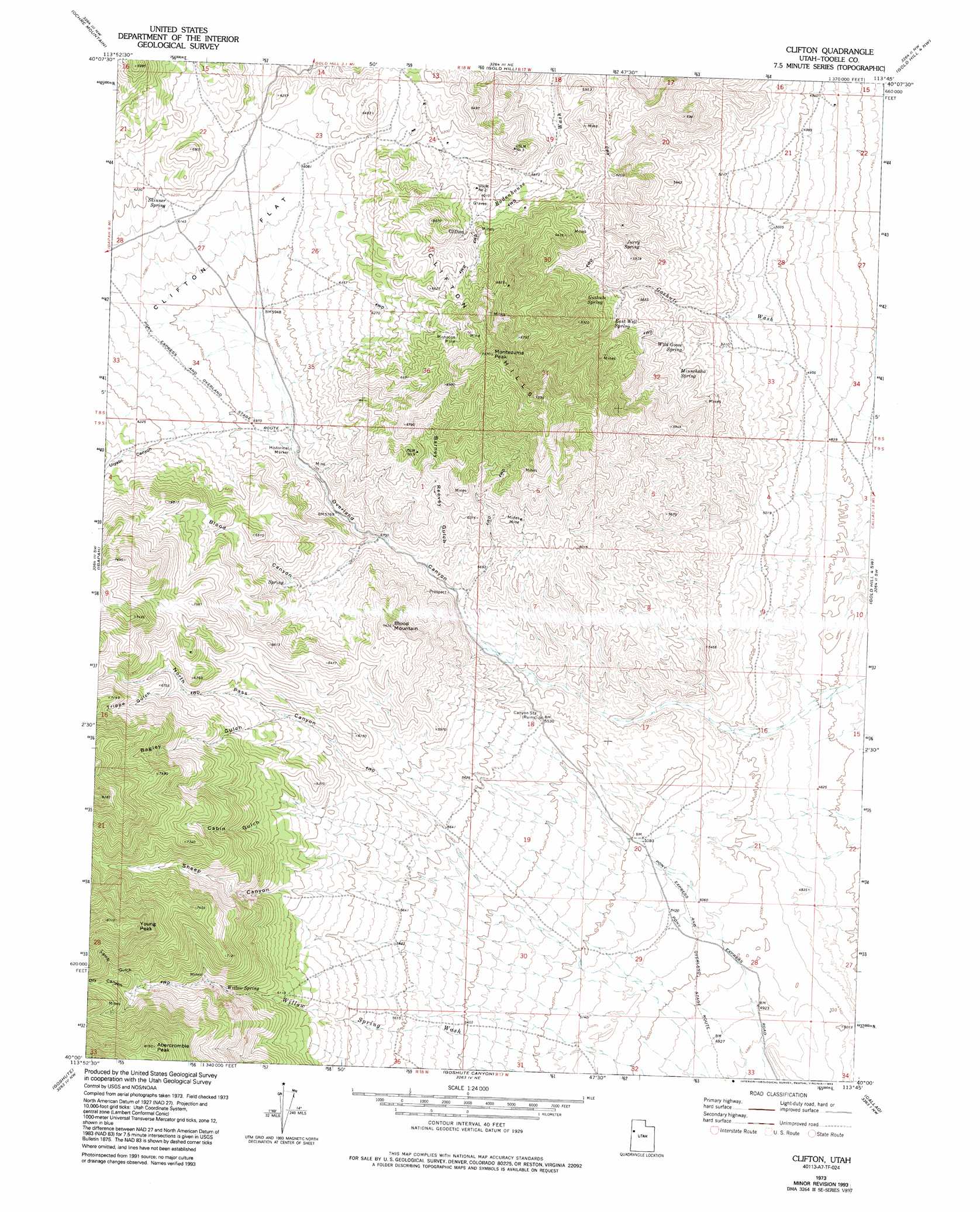
Clifton Topo Map Utah
To zoom in, hover over the map of Clifton
USGS Topo Quad 40113a7 - 1:24,000 scale
| Topo Map Name: | Clifton |
| USGS Topo Quad ID: | 40113a7 |
| Print Size: | ca. 21 1/4" wide x 27" high |
| Southeast Coordinates: | 40° N latitude / 113.75° W longitude |
| Map Center Coordinates: | 40.0625° N latitude / 113.8125° W longitude |
| U.S. State: | UT |
| Filename: | o40113a7.jpg |
| Download Map JPG Image: | Clifton topo map 1:24,000 scale |
| Map Type: | Topographic |
| Topo Series: | 7.5´ |
| Map Scale: | 1:24,000 |
| Source of Map Images: | United States Geological Survey (USGS) |
| Alternate Map Versions: |
Clifton UT 1973, updated 1987 Download PDF Buy paper map Clifton UT 1973, updated 1993 Download PDF Buy paper map Clifton UT 2011 Download PDF Buy paper map Clifton UT 2014 Download PDF Buy paper map |
1:24,000 Topo Quads surrounding Clifton
Utah Peak |
Elephant Knoll |
Elephant Knoll Se |
Gold Hill 1 Sw |
Gold Hill 1 Se |
Ferber Peak |
Ochre Mountain |
Gold Hill |
Gold Hill 4 Nw |
Gold Hill 4 Ne |
Ferber Peak Se |
Ibapah |
Clifton |
Gold Hill 4 Sw |
Gold Hill 4 Se |
Georgetta Ranch |
Goshute |
Goshute Canyon |
Callao |
Callao Ne |
Weaver Canyon |
Ibapah Peak |
Indian Farm Creek |
Mud Lake Reservoir |
Boyd Station |
> Back to 40113a1 at 1:100,000 scale
> Back to 40112a1 at 1:250,000 scale
> Back to U.S. Topo Maps home
Clifton topo map: Gazetteer
Clifton: Flats
Clifton Flat elevation 1835m 6020′Clifton: Mines
Midas Mine elevation 1873m 6145′Monocco Mine elevation 2104m 6902′
Clifton: Populated Places
Clifton elevation 1897m 6223′Clifton: Springs
East Well Spring elevation 1768m 5800′Goshute Spring elevation 1744m 5721′
Jurry Spring elevation 1699m 5574′
Minnehaha Spring elevation 1646m 5400′
Skinner Spring elevation 1881m 6171′
Wild Goose Spring elevation 1641m 5383′
Willow Spring elevation 1949m 6394′
Clifton: Summits
Abercrombie Peak elevation 2475m 8120′Blood Mountain elevation 1995m 6545′
Clifton Hills elevation 1986m 6515′
Montezuma Peak elevation 2201m 7221′
Young Peak elevation 2427m 7962′
Clifton: Valleys
Bagley Gulch elevation 1878m 6161′Barney Reevey Gulch elevation 1738m 5702′
Blood Canyon elevation 1804m 5918′
Cabin Gulch elevation 1729m 5672′
Dry Canyon elevation 2090m 6856′
Lamb Gulch elevation 2096m 6876′
North Pass Canyon elevation 1583m 5193′
Overland Canyon elevation 1510m 4954′
Sheep Canyon elevation 1561m 5121′
Trippe Gulch elevation 1979m 6492′
Uiyabi Canyon elevation 1814m 5951′
Clifton digital topo map on disk
Buy this Clifton topo map showing relief, roads, GPS coordinates and other geographical features, as a high-resolution digital map file on DVD: