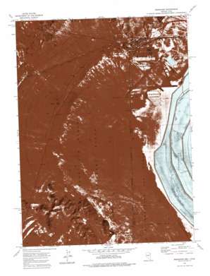
Wendover Topo Map Nevada
To zoom in, hover over the map of Wendover
USGS Topo Quad 40114f1 - 1:24,000 scale
| Topo Map Name: | Wendover |
| USGS Topo Quad ID: | 40114f1 |
| Print Size: | ca. 21 1/4" wide x 27" high |
| Southeast Coordinates: | 40.625° N latitude / 114° W longitude |
| Map Center Coordinates: | 40.6875° N latitude / 114.0625° W longitude |
| U.S. States: | NV, UT |
| Filename: | p40114f1.jpg |
| Download Map JPG Image: | Wendover topo map 1:24,000 scale |
| Map Type: | Orthophoto |
| Topo Series: | 7.5´ |
| Map Scale: | 1:24,000 |
| Source of Map Images: | United States Geological Survey (USGS) |
| Alternate Map Versions: |
Wendover UT 1972, updated 1977 Download PDF Buy paper map Wendover UT 2011 Download PDF Buy paper map Wendover UT 2014 Download PDF Buy paper map Wendover UT 2017 Download PDF Buy paper map |
1:24,000 Topo Quads surrounding Wendover
> Back to 40114e1 at 1:100,000 scale
> Back to 40114a1 at 1:250,000 scale
> Back to U.S. Topo Maps home
Wendover topo map: Gazetteer
Wendover: Airports
Bush Leland Landing Strip elevation 1321m 4333′Dover Field elevation 1314m 4311′
United States Pollution Control Heliport elevation 1286m 4219′
Wendover Airport elevation 1291m 4235′
Wendover Heliport elevation 1287m 4222′
Wendover: Cliffs
Ninemile elevation 1434m 4704′Wendover: Crossings
West Wendover Interchange elevation 1336m 4383′Wendover: Pillars
Needle Point elevation 1583m 5193′Window Rock elevation 1583m 5193′
Wendover: Populated Places
Eastline elevation 1337m 4386′Wendover elevation 1308m 4291′
West Wendover elevation 1360m 4461′
Wendover digital topo map on disk
Buy this Wendover topo map showing relief, roads, GPS coordinates and other geographical features, as a high-resolution digital map file on DVD:


