Ruby Lake Nw Topo Map Nevada
To zoom in, hover over the map of Ruby Lake Nw
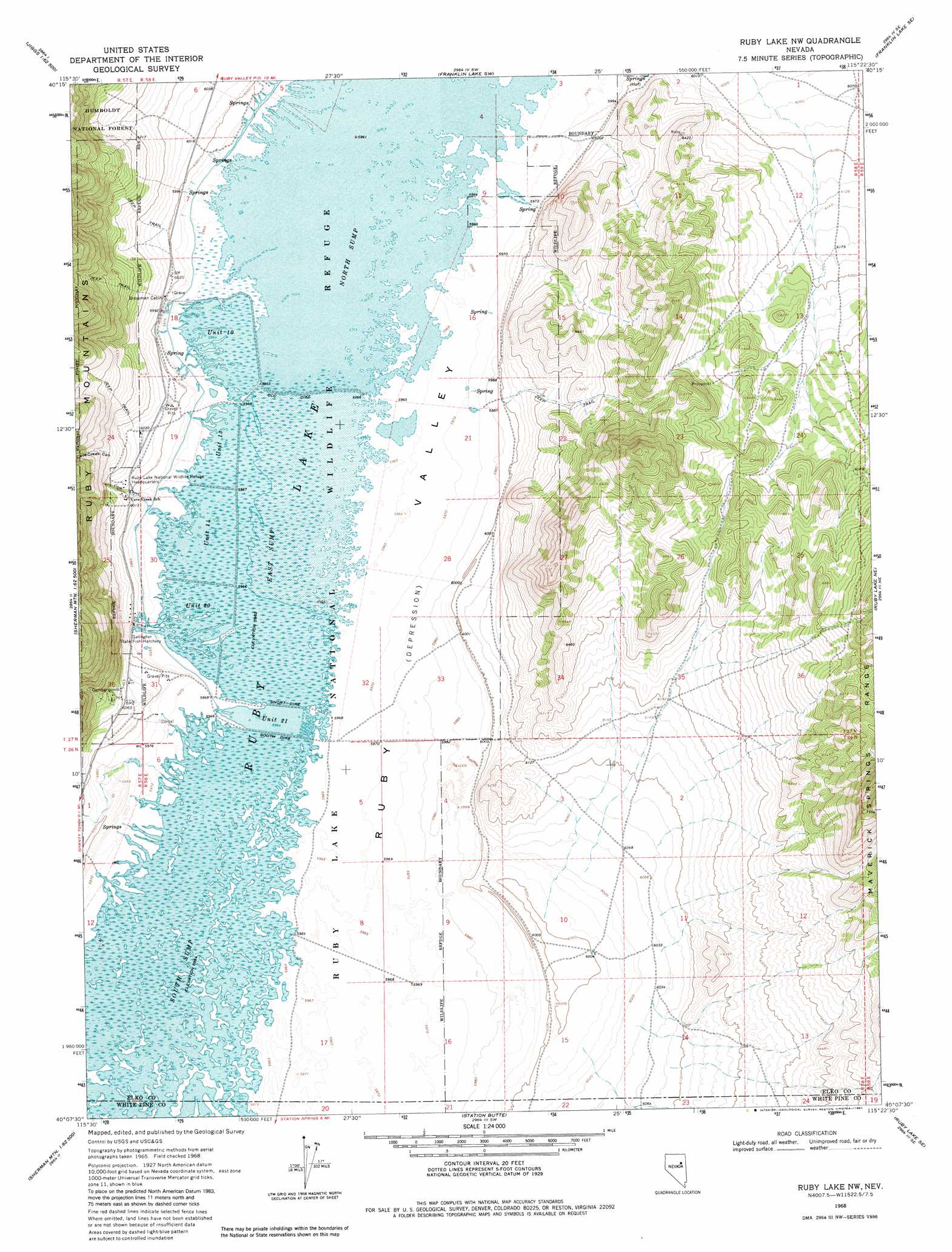
USGS Topo Quad 40115b4 - 1:24,000 scale
| Topo Map Name: | Ruby Lake Nw |
| USGS Topo Quad ID: | 40115b4 |
| Print Size: | ca. 21 1/4" wide x 27" high |
| Southeast Coordinates: | 40.125° N latitude / 115.375° W longitude |
| Map Center Coordinates: | 40.1875° N latitude / 115.4375° W longitude |
| U.S. State: | NV |
| Filename: | o40115b4.jpg |
| Download Map JPG Image: | Ruby Lake Nw topo map 1:24,000 scale |
| Map Type: | Topographic |
| Topo Series: | 7.5´ |
| Map Scale: | 1:24,000 |
| Source of Map Images: | United States Geological Survey (USGS) |
| Alternate Map Versions: |
Ruby Lake NW NV 1968, updated 1971 Download PDF Buy paper map Ruby Lake NW NV 1968, updated 1981 Download PDF Buy paper map Ruby Lake NW NV 2012 Download PDF Buy paper map Ruby Lake NW NV 2015 Download PDF Buy paper map |
| FStopo: | US Forest Service topo Ruby Lake NW is available: Download FStopo PDF Download FStopo TIF |
1:24,000 Topo Quads surrounding Ruby Lake Nw
Jiggs |
Green Mountain |
Franklin Lake Nw |
Franklin Lake Ne |
West Of Delcer Buttes |
Frost Creek |
Harrison Pass |
Franklin Lake Sw |
Franklin Lake Se |
Medicine Spring |
Belmont Creek |
Pearl Peak |
Ruby Lake Nw |
Ruby Lake Ne |
High Bald Peaks |
Walker Canyon |
Sherman Mountain |
Station Butte |
Ruby Lake Se |
Pot Spring |
Cold Creek Ranch Nw |
Big Bald Mountain |
Tognini Spring |
Junction Well |
Ninemile Well Nw |
> Back to 40115a1 at 1:100,000 scale
> Back to 40114a1 at 1:250,000 scale
> Back to U.S. Topo Maps home
Ruby Lake Nw topo map: Gazetteer
Ruby Lake Nw: Lakes
Ruby Lake elevation 1818m 5964′Ruby Lake Nw: Levees
C C C Dike elevation 1819m 5967′Short Dike elevation 1819m 5967′
South Dike elevation 1819m 5967′
Ruby Lake Nw: Parks
Ruby Lake National Wildlife Refuge elevation 1819m 5967′Ruby Lake Nw: Populated Places
Cavecreek (historical) elevation 1829m 6000′Ruby Lake Nw: Post Offices
Cave Creek Post Office (historical) elevation 1830m 6003′Ruby Lake Nw: Reservoirs
Ruby Lake Unit Fourteen elevation 1819m 5967′Ruby Lake Unit Ten elevation 1819m 5967′
Ruby Lake Unit Thirteen elevation 1819m 5967′
Ruby Lake Unit Twenty elevation 1819m 5967′
Ruby Lake Unit Twenty-one elevation 1819m 5967′
Ruby Lake Nw: Springs
Gardner Spring elevation 1821m 5974′Ruby Lake Nw: Streams
Cave Creek elevation 1820m 5971′Ruby Lake Nw: Swamps
Ruby Lake East Marsh elevation 1819m 5967′Ruby Lake North Marsh elevation 1819m 5967′
Ruby Lake South Marsh elevation 1819m 5967′
Ruby Lake Nw: Valleys
Cave Creek Canyon elevation 1884m 6181′Ruby Lake Nw digital topo map on disk
Buy this Ruby Lake Nw topo map showing relief, roads, GPS coordinates and other geographical features, as a high-resolution digital map file on DVD: