Boyd Reservoir Topo Map Nevada
To zoom in, hover over the map of Boyd Reservoir
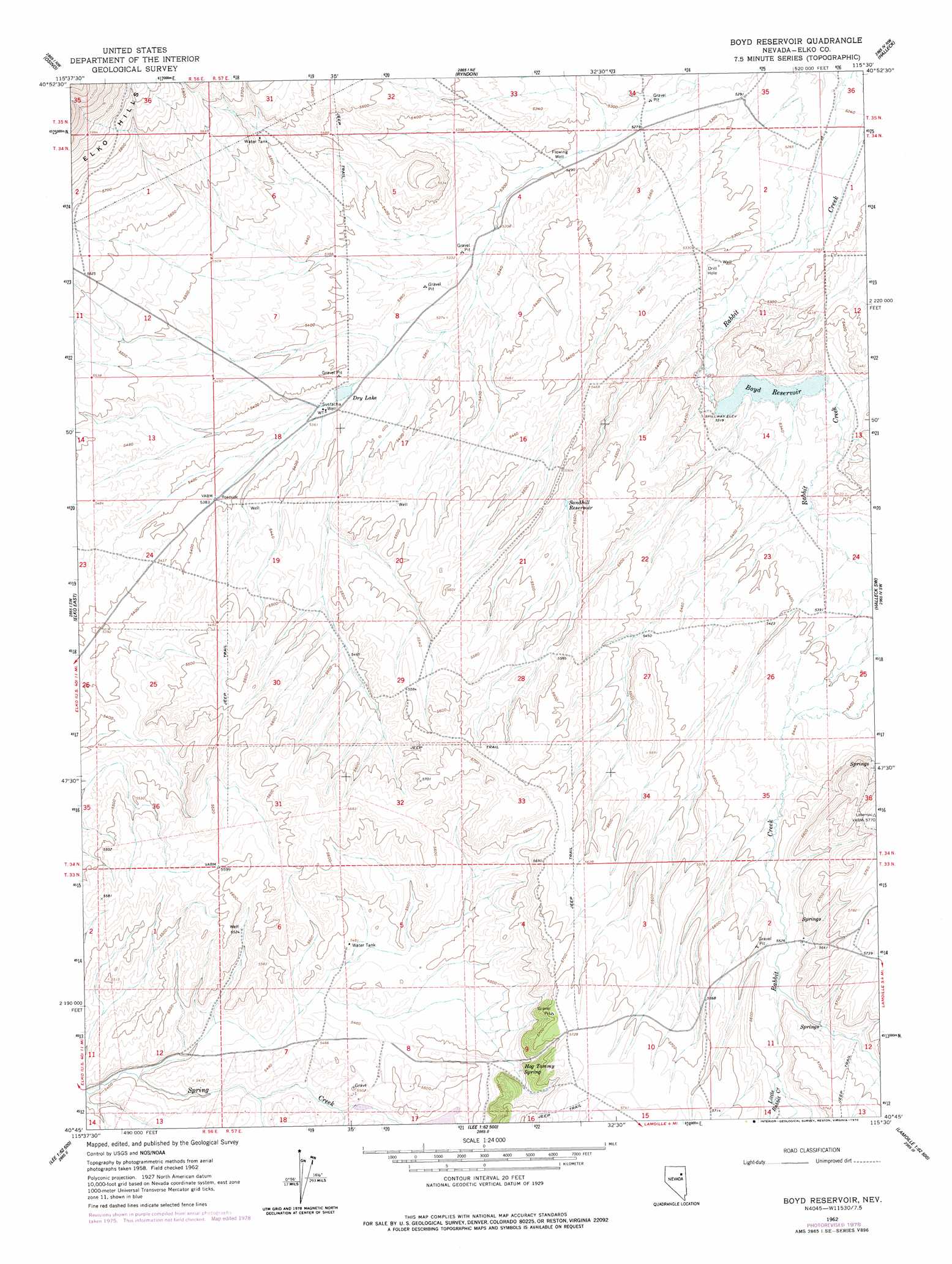
USGS Topo Quad 40115g5 - 1:24,000 scale
| Topo Map Name: | Boyd Reservoir |
| USGS Topo Quad ID: | 40115g5 |
| Print Size: | ca. 21 1/4" wide x 27" high |
| Southeast Coordinates: | 40.75° N latitude / 115.5° W longitude |
| Map Center Coordinates: | 40.8125° N latitude / 115.5625° W longitude |
| U.S. State: | NV |
| Filename: | o40115g5.jpg |
| Download Map JPG Image: | Boyd Reservoir topo map 1:24,000 scale |
| Map Type: | Topographic |
| Topo Series: | 7.5´ |
| Map Scale: | 1:24,000 |
| Source of Map Images: | United States Geological Survey (USGS) |
| Alternate Map Versions: |
Boyd Reservoir NV 1962, updated 1964 Download PDF Buy paper map Boyd Reservoir NV 1962, updated 1978 Download PDF Buy paper map Boyd Reservoir NV 2012 Download PDF Buy paper map Boyd Reservoir NV 2014 Download PDF Buy paper map |
1:24,000 Topo Quads surrounding Boyd Reservoir
Dinner Station |
The Buttes |
Coal Mine Canyon Se |
Morgan Hill |
Deeth |
Kittridge Springs |
Osino |
Ryndon |
Halleck |
Heelfly Creek |
Elko West |
Elko East |
Boyd Reservoir |
Halleck Sw |
Soldier Peak |
White Flats |
Te-Moak Well |
Noon Rock |
Lamoille |
Verdi Peak |
Red Spring |
West Of Lee |
Lee |
Ruby Dome |
Ruby Valley School |
> Back to 40115e1 at 1:100,000 scale
> Back to 40114a1 at 1:250,000 scale
> Back to U.S. Topo Maps home
Boyd Reservoir topo map: Gazetteer
Boyd Reservoir: Dams
Boyd Reservoir Dam elevation 1620m 5314′Boyd Reservoir: Lakes
Dry Lake elevation 1634m 5360′Boyd Reservoir: Reservoirs
Boyd Reservoir elevation 1620m 5314′Sandhill Reservoir elevation 1658m 5439′
Boyd Reservoir: Springs
Hog Tommy Spring elevation 1702m 5583′Sandhill Spring elevation 1658m 5439′
Boyd Reservoir: Streams
Little Rabbit Creek elevation 1708m 5603′Boyd Reservoir: Summits
Hog Tommy Hill elevation 1758m 5767′Boyd Reservoir: Wells
Sustacha Well elevation 1636m 5367′Boyd Reservoir digital topo map on disk
Buy this Boyd Reservoir topo map showing relief, roads, GPS coordinates and other geographical features, as a high-resolution digital map file on DVD: