Humboldt Peak Topo Map Nevada
To zoom in, hover over the map of Humboldt Peak
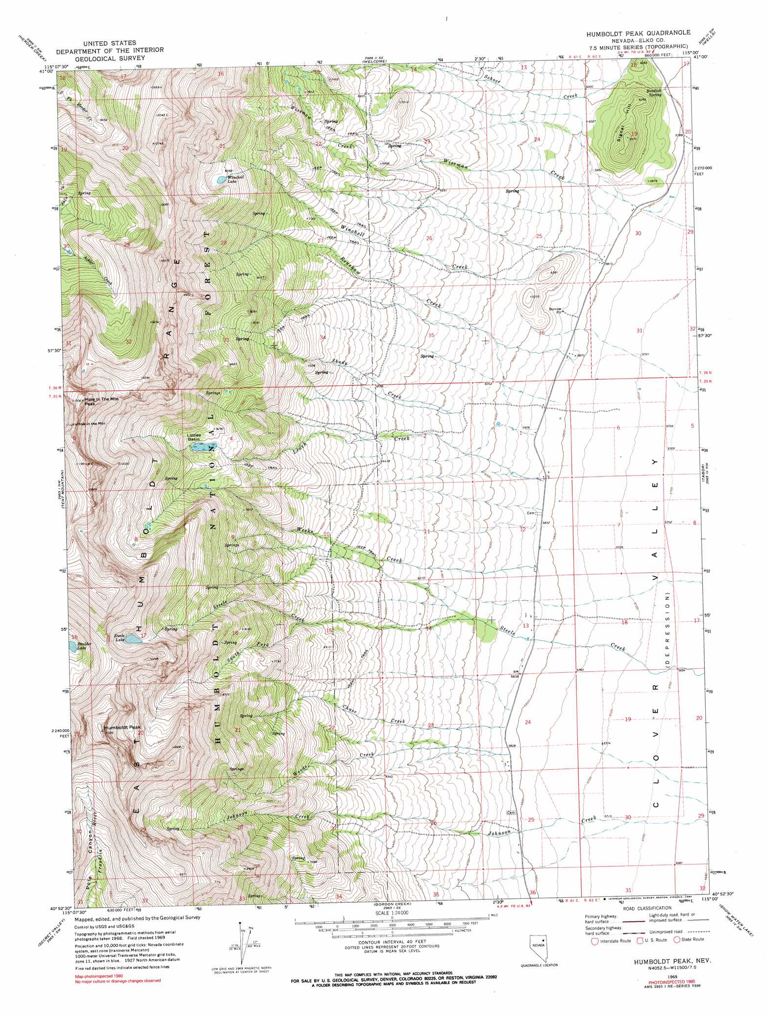
USGS Topo Quad 40115h1 - 1:24,000 scale
| Topo Map Name: | Humboldt Peak |
| USGS Topo Quad ID: | 40115h1 |
| Print Size: | ca. 21 1/4" wide x 27" high |
| Southeast Coordinates: | 40.875° N latitude / 115° W longitude |
| Map Center Coordinates: | 40.9375° N latitude / 115.0625° W longitude |
| U.S. State: | NV |
| Filename: | o40115h1.jpg |
| Download Map JPG Image: | Humboldt Peak topo map 1:24,000 scale |
| Map Type: | Topographic |
| Topo Series: | 7.5´ |
| Map Scale: | 1:24,000 |
| Source of Map Images: | United States Geological Survey (USGS) |
| Alternate Map Versions: |
Humboldt Peak NV 1969, updated 1973 Download PDF Buy paper map Humboldt Peak NV 1969, updated 1990 Download PDF Buy paper map Humboldt Peak NV 1969, updated 1990 Download PDF Buy paper map Humboldt Peak NV 2012 Download PDF Buy paper map Humboldt Peak NV 2014 Download PDF Buy paper map |
| FStopo: | US Forest Service topo Humboldt Peak is available: Download FStopo PDF Download FStopo TIF |
1:24,000 Topo Quads surrounding Humboldt Peak
Twin Buttes |
Tabor Flats |
Metropolis |
Oxley Peak |
Wells Peak |
Deeth |
Herder Creek |
Welcome |
Wells |
Moor Summit |
Heelfly Creek |
Tent Mountain |
Humboldt Peak |
Tobar |
Snow Water Lake Ne |
Soldier Peak |
Secret Valley |
Gordon Creek |
Snow Water Lake |
Ventosa |
Verdi Peak |
Ruby City Creek |
Arizona Spring |
Spruce Mountain Nw |
Chase Spring |
> Back to 40115e1 at 1:100,000 scale
> Back to 40114a1 at 1:250,000 scale
> Back to U.S. Topo Maps home
Humboldt Peak topo map: Gazetteer
Humboldt Peak: Arches
Hole in the Mountain elevation 3356m 11010′Humboldt Peak: Basins
Lizzies Basin elevation 2485m 8152′Humboldt Peak: Lakes
Steele Lake elevation 2910m 9547′Winchell Lake elevation 2630m 8628′
Humboldt Peak: Populated Places
Wood (historical) elevation 1774m 5820′Humboldt Peak: Post Offices
Wood Post Office (historical) elevation 1774m 5820′Humboldt Peak: Ranges
East Humboldt Range elevation 3366m 11043′Humboldt Peak: Springs
Bradish Spring elevation 1774m 5820′Humboldt Peak: Streams
Chase Creek elevation 1778m 5833′Leach Creek elevation 1778m 5833′
Renshaw Creek elevation 1778m 5833′
Schoer Creek elevation 1795m 5889′
Shady Creek elevation 1867m 6125′
South Fork Steele Creek elevation 2108m 6916′
Weeks Creek elevation 1781m 5843′
Winchell Creek elevation 1779m 5836′
Wiseman Creek elevation 1776m 5826′
Woods Creek elevation 1777m 5830′
Humboldt Peak: Summits
Hole in the Mountain Peak elevation 3440m 11286′Humboldt Peak elevation 3349m 10987′
Signal Hill elevation 1965m 6446′
Humboldt Peak digital topo map on disk
Buy this Humboldt Peak topo map showing relief, roads, GPS coordinates and other geographical features, as a high-resolution digital map file on DVD: