Carico Lake South Topo Map Nevada
To zoom in, hover over the map of Carico Lake South
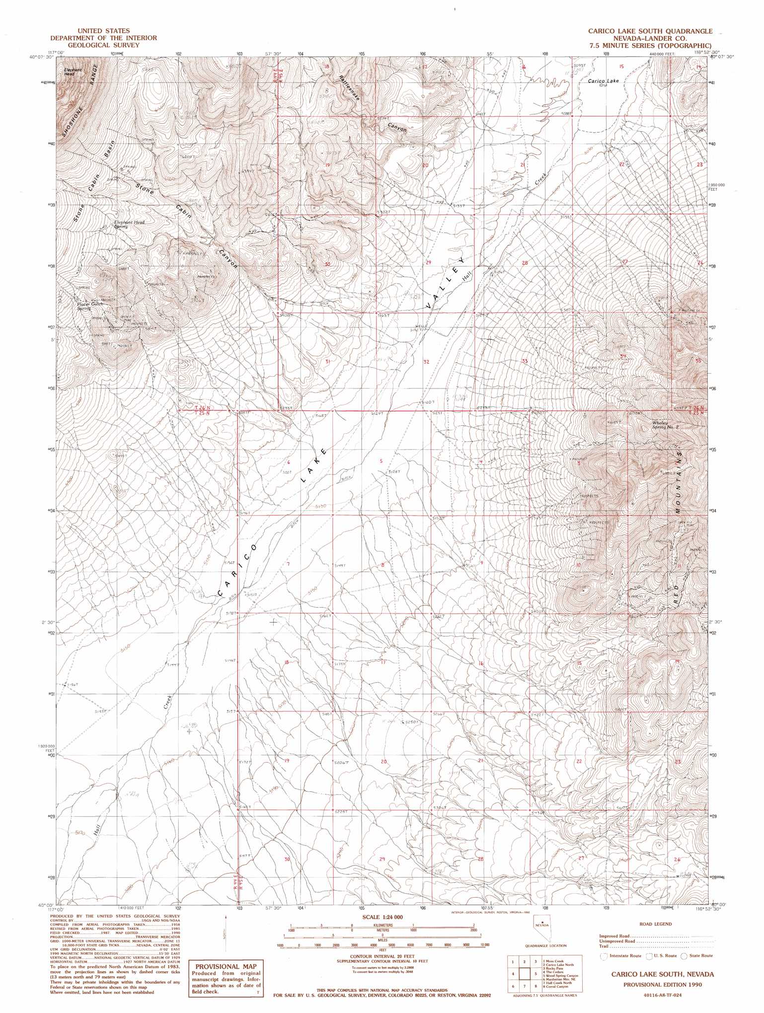
USGS Topo Quad 40116a8 - 1:24,000 scale
| Topo Map Name: | Carico Lake South |
| USGS Topo Quad ID: | 40116a8 |
| Print Size: | ca. 21 1/4" wide x 27" high |
| Southeast Coordinates: | 40° N latitude / 116.875° W longitude |
| Map Center Coordinates: | 40.0625° N latitude / 116.9375° W longitude |
| U.S. State: | NV |
| Filename: | o40116a8.jpg |
| Download Map JPG Image: | Carico Lake South topo map 1:24,000 scale |
| Map Type: | Topographic |
| Topo Series: | 7.5´ |
| Map Scale: | 1:24,000 |
| Source of Map Images: | United States Geological Survey (USGS) |
| Alternate Map Versions: |
Carico Lake South NV 1990, updated 1990 Download PDF Buy paper map Carico Lake South NV 2012 Download PDF Buy paper map Carico Lake South NV 2014 Download PDF Buy paper map |
1:24,000 Topo Quads surrounding Carico Lake South
Mccoy |
Redrock Spring |
Goat Peak |
Ferris Creek |
Tenabo |
Fish Creek Ranch |
Moss Creek |
Carico Lake North |
Rocky Pass |
Cortez Canyon |
The Cedars Sw |
The Cedars |
Carico Lake South |
Wood Spring Canyon |
Wenban Spring |
Manhattan Mountain Nw |
Manhattan Mountain Ne |
Hall Creek North |
Corral Canyon |
Little Hot Springs |
Manhattan Mountain |
Joe Eason Mountain |
Hall Creek South |
Cowboy Rest Creek |
West Of Fagin Mountain |
> Back to 40116a1 at 1:100,000 scale
> Back to 40116a1 at 1:250,000 scale
> Back to U.S. Topo Maps home
Carico Lake South topo map: Gazetteer
Carico Lake South: Basins
Stone Cabin Basin elevation 1932m 6338′Carico Lake South: Springs
Elephant Head Spring elevation 1879m 6164′Placer Gulch Spring elevation 1857m 6092′
Stone Cabin Spring elevation 1664m 5459′
Wholey Spring Number Two elevation 1881m 6171′
Carico Lake South: Streams
Hall Creek elevation 1552m 5091′Carico Lake South: Summits
Red Mountains elevation 2098m 6883′Carico Lake South: Valleys
Rattlesnake Canyon elevation 1590m 5216′Stone Cabin Canyon elevation 1571m 5154′
Carico Lake South: Wells
Filippini Well (historical) elevation 1587m 5206′Laborde Well (historical) elevation 1561m 5121′
Wholey Well Number Two (historical) elevation 1566m 5137′
Wholeys Well Number Three elevation 1563m 5127′
Carico Lake South digital topo map on disk
Buy this Carico Lake South topo map showing relief, roads, GPS coordinates and other geographical features, as a high-resolution digital map file on DVD: