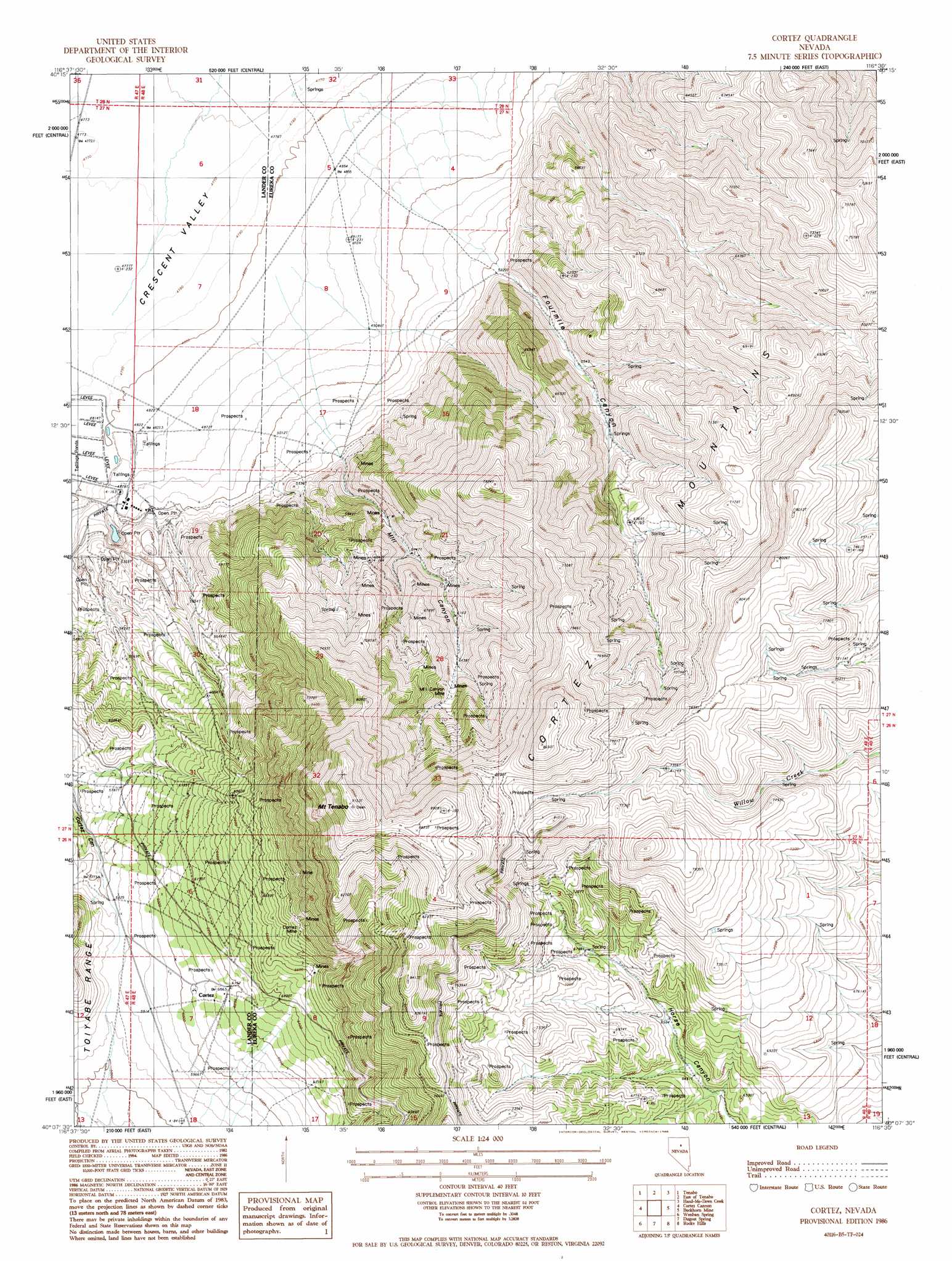
Cortez Topo Map Nevada
To zoom in, hover over the map of Cortez
USGS Topo Quad 40116b5 - 1:24,000 scale
| Topo Map Name: | Cortez |
| USGS Topo Quad ID: | 40116b5 |
| Print Size: | ca. 21 1/4" wide x 27" high |
| Southeast Coordinates: | 40.125° N latitude / 116.5° W longitude |
| Map Center Coordinates: | 40.1875° N latitude / 116.5625° W longitude |
| U.S. State: | NV |
| Filename: | o40116b5.jpg |
| Download Map JPG Image: | Cortez topo map 1:24,000 scale |
| Map Type: | Topographic |
| Topo Series: | 7.5´ |
| Map Scale: | 1:24,000 |
| Source of Map Images: | United States Geological Survey (USGS) |
| Alternate Map Versions: |
Cortez NV 1986, updated 1986 Download PDF Buy paper map Cortez NV 2012 Download PDF Buy paper map Cortez NV 2014 Download PDF Buy paper map |
1:24,000 Topo Quads surrounding Cortez
Mount Lewis |
Mud Spring Gulch |
Crescent Valley |
Tumbleweed Flat |
Frenchie Flat |
Ferris Creek |
Tenabo |
East Of Tenabo |
Hand-Me-Down Creek |
Thatcher Spring |
Rocky Pass |
Cortez Canyon |
Cortez |
Buckhorn Mine |
Curlow Flat |
Wood Spring Canyon |
Wenban Spring |
Dugout Spring |
Rocky Hills |
Pete Hanson Creek |
Corral Canyon |
Little Hot Springs |
Walti Hot Springs |
Tonkin Summit |
Cooper Peak |
> Back to 40116a1 at 1:100,000 scale
> Back to 40116a1 at 1:250,000 scale
> Back to U.S. Topo Maps home
Cortez topo map: Gazetteer
Cortez: Flats
Big Field Number One elevation 2117m 6945′Big Field Number Two elevation 2065m 6774′
Cortez: Mines
Artic Mine elevation 1844m 6049′Benjamin Harrison Mine elevation 1989m 6525′
Berlin Mine elevation 1748m 5734′
Bullion Hill Mine elevation 2159m 7083′
Caledonia Mine elevation 1715m 5626′
Cortez Gold Mine elevation 1577m 5173′
Cortez Mine elevation 2114m 6935′
Empire State Mine elevation 1977m 6486′
Falconer Mine elevation 1935m 6348′
Fitzgerald Mine elevation 1844m 6049′
Lewis Canyon Mines elevation 1936m 6351′
Mill Canyon Mine elevation 2154m 7066′
Mount Tenabo Mine elevation 1844m 6049′
New York Mine elevation 1681m 5515′
Saint Louis Mine elevation 1844m 6049′
Cortez: Populated Places
Cortez elevation 1869m 6131′Cortez: Post Offices
Cortez Post Office (historical) elevation 1869m 6131′Cortez: Springs
Buckhorn Spring elevation 2289m 7509′Cherry Tree Spring elevation 2025m 6643′
Dean Spring Number One elevation 2211m 7253′
Dean Spring Number Three elevation 1755m 5757′
Dean Spring Number Two elevation 2163m 7096′
Goyeneche Spring Number Four elevation 2134m 7001′
Goyeneche Spring Number Six elevation 2320m 7611′
Mule Canyon Spring elevation 1955m 6414′
Rimrock Spring elevation 2047m 6715′
Rimrock Springs elevation 2254m 7395′
Sidehill Blue Spring elevation 2294m 7526′
Tub Spring elevation 2346m 7696′
Willow Spring elevation 2241m 7352′
Cortez: Streams
Mill Creek elevation 1475m 4839′West Fork Mill Creek elevation 1975m 6479′
Cortez: Summits
Mount Tenabo elevation 2725m 8940′Cortez: Valleys
Fourmile Canyon elevation 1568m 5144′Mill Canyon elevation 1571m 5154′
Cortez digital topo map on disk
Buy this Cortez topo map showing relief, roads, GPS coordinates and other geographical features, as a high-resolution digital map file on DVD: