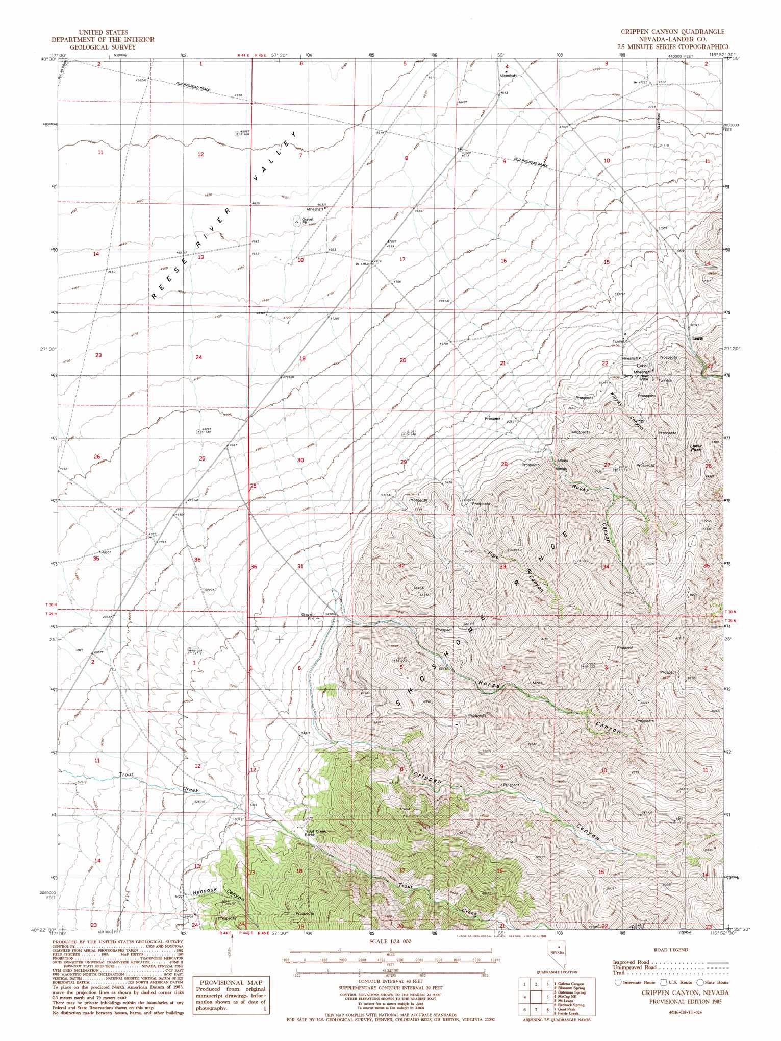
Crippen Canyon Topo Map Nevada
To zoom in, hover over the map of Crippen Canyon
USGS Topo Quad 40116d8 - 1:24,000 scale
| Topo Map Name: | Crippen Canyon |
| USGS Topo Quad ID: | 40116d8 |
| Print Size: | ca. 21 1/4" wide x 27" high |
| Southeast Coordinates: | 40.375° N latitude / 116.875° W longitude |
| Map Center Coordinates: | 40.4375° N latitude / 116.9375° W longitude |
| U.S. State: | NV |
| Filename: | o40116d8.jpg |
| Download Map JPG Image: | Crippen Canyon topo map 1:24,000 scale |
| Map Type: | Topographic |
| Topo Series: | 7.5´ |
| Map Scale: | 1:24,000 |
| Source of Map Images: | United States Geological Survey (USGS) |
| Alternate Map Versions: |
Crippen Canyon NV 1985, updated 1986 Download PDF Buy paper map Crippen Canyon NV 2012 Download PDF Buy paper map Crippen Canyon NV 2014 Download PDF Buy paper map |
1:24,000 Topo Quads surrounding Crippen Canyon
North Peak |
Snow Gulch |
Battle Mountain |
Stony Point |
Argenta |
Antler Peak |
Galena |
Blossom Spring |
Bateman Spring |
Mule Canyon |
Mccoy Nw |
Mccoy Ne |
Crippen Canyon |
Mount Lewis |
Mud Spring Gulch |
Mccoy |
Redrock Spring |
Goat Peak |
Ferris Creek |
Tenabo |
Fish Creek Ranch |
Moss Creek |
Carico Lake North |
Rocky Pass |
Cortez Canyon |
> Back to 40116a1 at 1:100,000 scale
> Back to 40116a1 at 1:250,000 scale
> Back to U.S. Topo Maps home
Crippen Canyon topo map: Gazetteer
Crippen Canyon: Mines
Betty O'Neal Mine elevation 1760m 5774′Big Florence Mine elevation 2064m 6771′
Echo Mine elevation 2298m 7539′
Florence Mine elevation 2049m 6722′
Frank O'Neal Mine elevation 2298m 7539′
Friberg Mine elevation 2298m 7539′
Gift Mine elevation 2298m 7539′
Gold and Silver Circle Mine elevation 2298m 7539′
Hillside Mine elevation 2298m 7539′
Horse Canyon Mine elevation 1896m 6220′
North Side Mine elevation 2341m 7680′
North Wall Mine elevation 2298m 7539′
Topsy Mine elevation 1678m 5505′
Yreka Mine elevation 2298m 7539′
Crippen Canyon: Populated Places
Betty O'Neal (historical) elevation 1652m 5419′Crippen Canyon: Post Offices
Betty O'Neal Post Office (historical) elevation 1655m 5429′Lewis Post Office elevation 1677m 5501′
Crippen Canyon: Springs
Horse Canyon Spring elevation 2403m 7883′Shale Spring elevation 2577m 8454′
Willow Spring elevation 2337m 7667′
Willow Spring elevation 1647m 5403′
Crippen Canyon: Streams
Lewis Bens Creek elevation 1524m 5000′Roaring Creek elevation 1525m 5003′
Sheep Creek elevation 1524m 5000′
Crippen Canyon: Summits
Lewis Peak elevation 2159m 7083′Crippen Canyon: Valleys
Crippen Canyon elevation 1646m 5400′Hancock Canyon elevation 1649m 5410′
Horse Canyon elevation 1639m 5377′
Lewis Canyon elevation 1745m 5725′
Pipe Canyon elevation 1643m 5390′
Rocky Canyon elevation 1639m 5377′
Whisky Canyon elevation 1645m 5396′
Crippen Canyon digital topo map on disk
Buy this Crippen Canyon topo map showing relief, roads, GPS coordinates and other geographical features, as a high-resolution digital map file on DVD: