Logan Peak Topo Map Nevada
To zoom in, hover over the map of Logan Peak
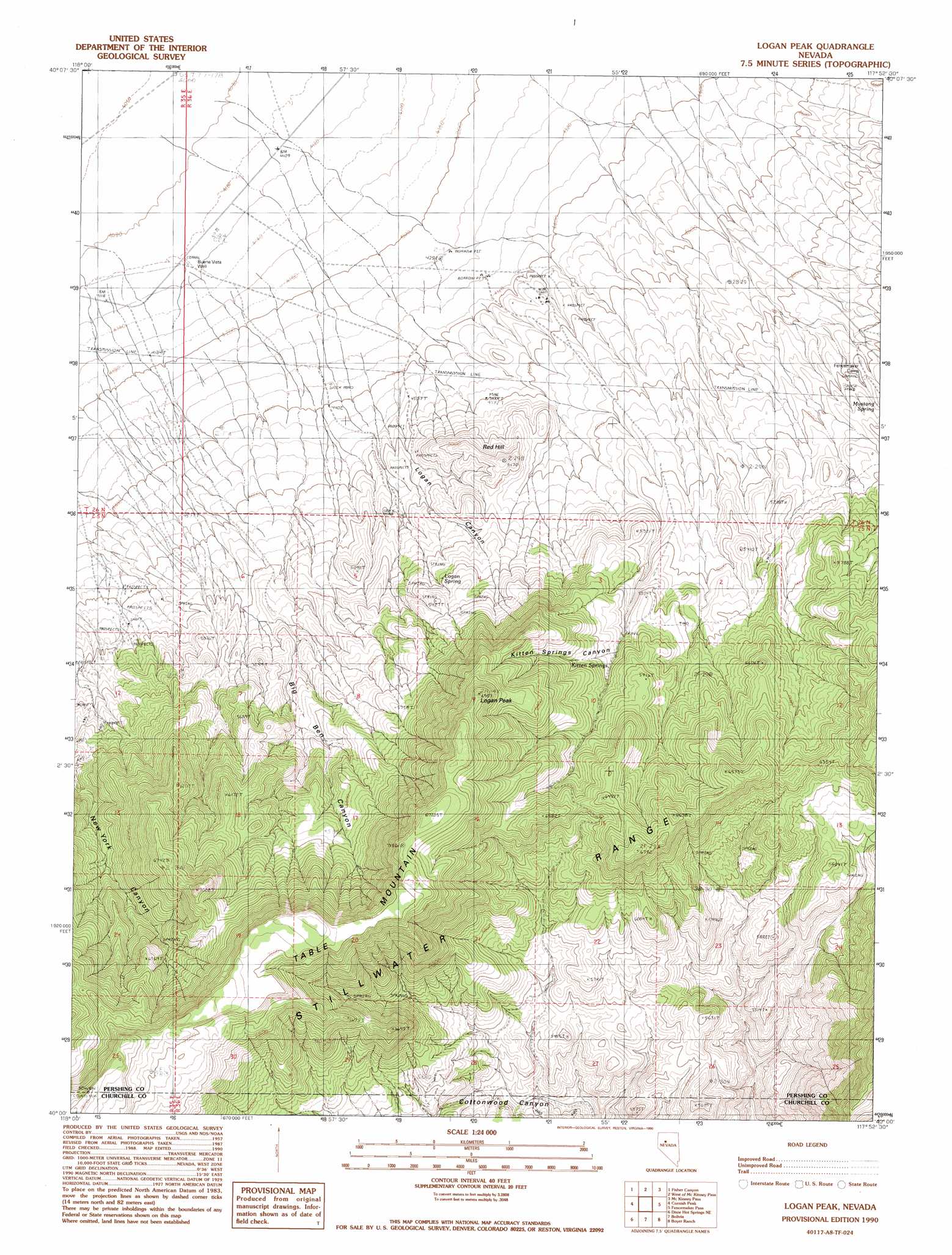
USGS Topo Quad 40117a8 - 1:24,000 scale
| Topo Map Name: | Logan Peak |
| USGS Topo Quad ID: | 40117a8 |
| Print Size: | ca. 21 1/4" wide x 27" high |
| Southeast Coordinates: | 40° N latitude / 117.875° W longitude |
| Map Center Coordinates: | 40.0625° N latitude / 117.9375° W longitude |
| U.S. State: | NV |
| Filename: | o40117a8.jpg |
| Download Map JPG Image: | Logan Peak topo map 1:24,000 scale |
| Map Type: | Topographic |
| Topo Series: | 7.5´ |
| Map Scale: | 1:24,000 |
| Source of Map Images: | United States Geological Survey (USGS) |
| Alternate Map Versions: |
Logan Peak NV 1990, updated 1990 Download PDF Buy paper map Logan Peak NV 2011 Download PDF Buy paper map Logan Peak NV 2014 Download PDF Buy paper map |
1:24,000 Topo Quads surrounding Logan Peak
Rochester |
Fitting |
Kyle Hot Springs Sw |
Granite Mountain |
Kennedy Canyon |
Buffalo Mountain |
Fisher Canyon |
West Of Mckinney Pass |
Mckinney Pass |
Sou Hills |
Buena Vista Hills North |
Cornish Peak |
Logan Peak |
Fencemaker Pass |
Sou Hot Springs |
Buena Vista Hills South |
Dixie Hot Springs Ne |
Bolivia |
Boyer Ranch |
Hole In The Wall |
Fondaway Canyon |
Dixie Hot Springs |
Humboldt Salt Marsh |
Bernice Canyon |
Shoshone Meadows |
> Back to 40117a1 at 1:100,000 scale
> Back to 40116a1 at 1:250,000 scale
> Back to U.S. Topo Maps home
Logan Peak topo map: Gazetteer
Logan Peak: Mines
Band M Mine elevation 1374m 4507′Freckles Mine elevation 1377m 4517′
Storm Mine elevation 1550m 5085′
Victory Mine elevation 1516m 4973′
Logan Peak: Springs
Hot Spring elevation 1631m 5351′Kitten Springs elevation 1754m 5754′
Logan Spring elevation 1543m 5062′
Mustang Spring elevation 1541m 5055′
Logan Peak: Summits
Logan Peak elevation 2112m 6929′Red Hill elevation 1576m 5170′
Table Mountain elevation 2168m 7112′
Logan Peak: Valleys
Big Ben Canyon elevation 1473m 4832′Kitten Springs Canyon elevation 1684m 5524′
Logan Canyon elevation 1390m 4560′
Logan Peak digital topo map on disk
Buy this Logan Peak topo map showing relief, roads, GPS coordinates and other geographical features, as a high-resolution digital map file on DVD: