Rose Creek Mountain Topo Map Nevada
To zoom in, hover over the map of Rose Creek Mountain
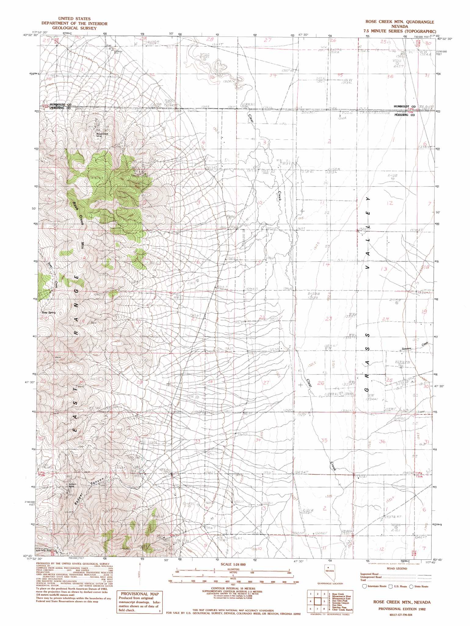
USGS Topo Quad 40117g7 - 1:24,000 scale
| Topo Map Name: | Rose Creek Mountain |
| USGS Topo Quad ID: | 40117g7 |
| Print Size: | ca. 21 1/4" wide x 27" high |
| Southeast Coordinates: | 40.75° N latitude / 117.75° W longitude |
| Map Center Coordinates: | 40.8125° N latitude / 117.8125° W longitude |
| U.S. State: | NV |
| Filename: | o40117g7.jpg |
| Download Map JPG Image: | Rose Creek Mountain topo map 1:24,000 scale |
| Map Type: | Topographic |
| Topo Series: | 7.5´ |
| Map Scale: | 1:24,000 |
| Source of Map Images: | United States Geological Survey (USGS) |
| Alternate Map Versions: |
Rose Creek Mtn NV 1982, updated 1982 Download PDF Buy paper map Rose Creek Mountain NV 2011 Download PDF Buy paper map Rose Creek Mountain NV 2014 Download PDF Buy paper map |
1:24,000 Topo Quads surrounding Rose Creek Mountain
Mormon Dan Butte |
Barrett Springs |
Winnemucca Mountain |
Weso |
Golconda Butte |
Pronto |
Rose Creek |
Winnemucca West |
Winnemucca East |
Pole Creek |
Cosgrave |
Dun Glen Peak |
Rose Creek Mountain |
Sonoma Canyon |
Adelaide |
Mill City |
Dun Glen |
Natchez Pass |
Clear Creek Ranch |
Sheep Ranch Canyon |
Star Creek Ranch |
Inskip Canyon |
Lee Peak |
Leach Hot Springs |
Panther Canyon |
> Back to 40117e1 at 1:100,000 scale
> Back to 40116a1 at 1:250,000 scale
> Back to U.S. Topo Maps home
Rose Creek Mountain topo map: Gazetteer
Rose Creek Mountain: Mines
Auburn Mine elevation 1890m 6200′Rose Creek Mine elevation 1484m 4868′
Rose Creek Mountain: Springs
Rose Spring elevation 1911m 6269′Rose Creek Mountain: Streams
Sonoma Creek elevation 1333m 4373′Rose Creek Mountain: Summits
Rose Creek Mountain elevation 2002m 6568′Rose Creek Mountain: Valleys
Badger Canyon elevation 1469m 4819′Grass Valley elevation 1311m 4301′
Rose Creek Mountain digital topo map on disk
Buy this Rose Creek Mountain topo map showing relief, roads, GPS coordinates and other geographical features, as a high-resolution digital map file on DVD: