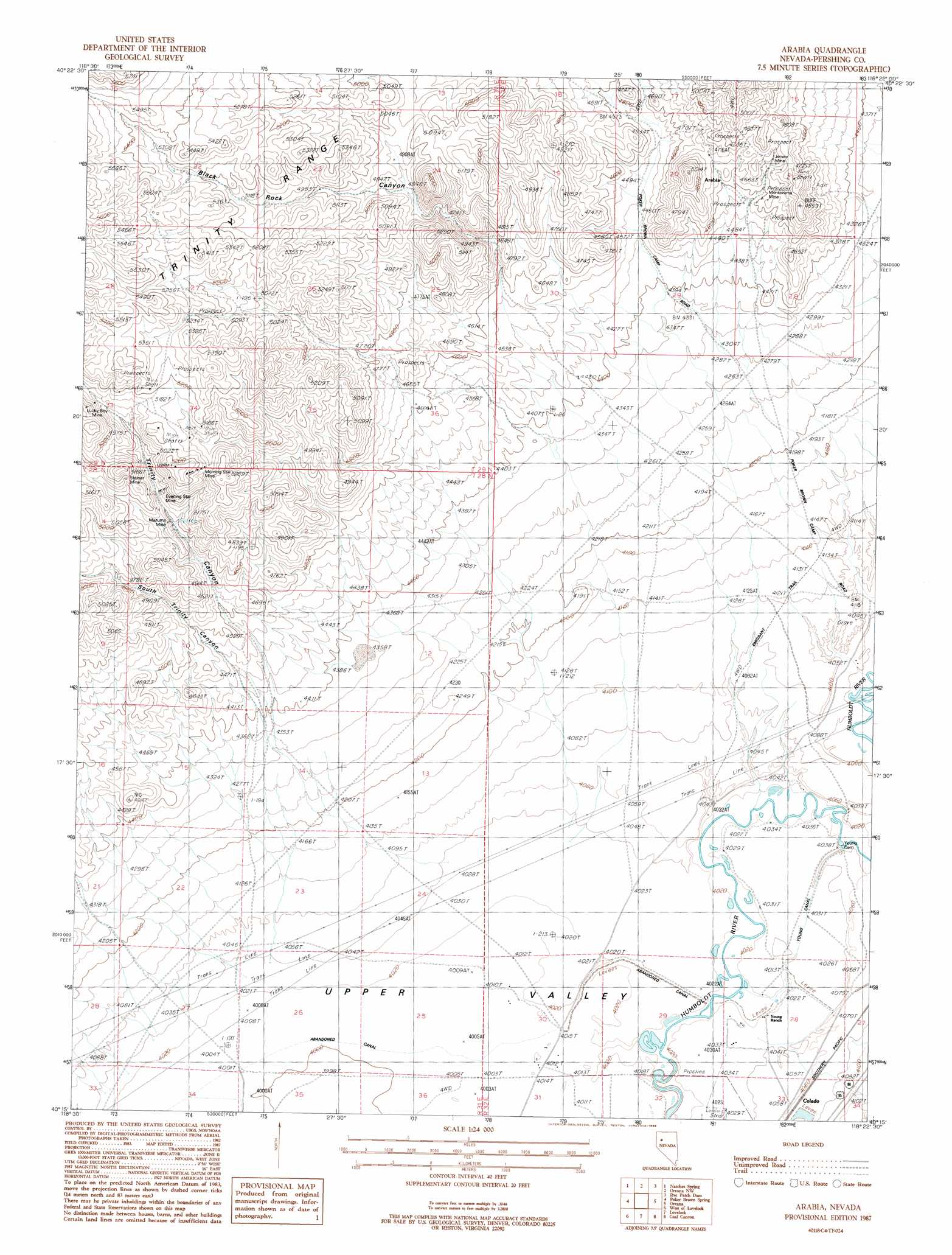
Arabia Topo Map Nevada
To zoom in, hover over the map of Arabia
USGS Topo Quad 40118c4 - 1:24,000 scale
| Topo Map Name: | Arabia |
| USGS Topo Quad ID: | 40118c4 |
| Print Size: | ca. 21 1/4" wide x 27" high |
| Southeast Coordinates: | 40.25° N latitude / 118.375° W longitude |
| Map Center Coordinates: | 40.3125° N latitude / 118.4375° W longitude |
| U.S. State: | NV |
| Filename: | o40118c4.jpg |
| Download Map JPG Image: | Arabia topo map 1:24,000 scale |
| Map Type: | Topographic |
| Topo Series: | 7.5´ |
| Map Scale: | 1:24,000 |
| Source of Map Images: | United States Geological Survey (USGS) |
| Alternate Map Versions: |
Arabia NV 1987, updated 1988 Download PDF Buy paper map Arabia NV 2011 Download PDF Buy paper map Arabia NV 2014 Download PDF Buy paper map |
1:24,000 Topo Quads surrounding Arabia
Rocky Canyon |
Poker Brown Gap |
Poker Brown |
Rye Patch Res South |
Star Peak |
Trinity Pass Nw |
Natchez Spring |
Oreana Nw |
Rye Patch Dam |
Congress Canyon |
Trinity Pass |
Poker Brown Spring |
Arabia |
Oreana |
Rochester |
Trinity Peak |
West Of Lovelock |
Lovelock |
Coal Canyon |
Buffalo Mountain |
Toulon Peak |
Granite Point |
Wildhorse Pass |
Wildhorse Spring |
Buena Vista Hills North |
> Back to 40118a1 at 1:100,000 scale
> Back to 40118a1 at 1:250,000 scale
> Back to U.S. Topo Maps home
Arabia topo map: Gazetteer
Arabia: Dams
Young Dam elevation 1227m 4025′Arabia: Mines
Electric Mine elevation 1429m 4688′Evening Star Mine elevation 1514m 4967′
Jersey Mine elevation 1440m 4724′
Lucky Boy Mine elevation 1579m 5180′
Mazuma Mine elevation 1488m 4881′
Montezuma Mine elevation 1411m 4629′
Morning Star Mine elevation 1580m 5183′
Steiner Mine elevation 1606m 5269′
West Group Mine elevation 1386m 4547′
Arabia: Populated Places
Arabia elevation 1437m 4714′Clarksville (historical) elevation 1459m 4786′
Arabia: Valleys
Black Rock Canyon elevation 1397m 4583′South Trinity Canyon elevation 1347m 4419′
Trinity Canyon elevation 1354m 4442′
Arabia digital topo map on disk
Buy this Arabia topo map showing relief, roads, GPS coordinates and other geographical features, as a high-resolution digital map file on DVD: