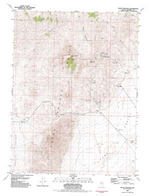
Seven Troughs Topo Map Nevada
To zoom in, hover over the map of Seven Troughs
USGS Topo Quad 40118d7 - 1:24,000 scale
| Topo Map Name: | Seven Troughs |
| USGS Topo Quad ID: | 40118d7 |
| Print Size: | ca. 21 1/4" wide x 27" high |
| Southeast Coordinates: | 40.375° N latitude / 118.75° W longitude |
| Map Center Coordinates: | 40.4375° N latitude / 118.8125° W longitude |
| U.S. State: | NV |
| Filename: | o40118d7.jpg |
| Download Map JPG Image: | Seven Troughs topo map 1:24,000 scale |
| Map Type: | Topographic |
| Topo Series: | 7.5´ |
| Map Scale: | 1:24,000 |
| Source of Map Images: | United States Geological Survey (USGS) |
| Alternate Map Versions: |
Seven Troughs NV 1981, updated 1982 Download PDF Buy paper map Seven Troughs NV 2011 Download PDF Buy paper map Seven Troughs NV 2015 Download PDF Buy paper map |
1:24,000 Topo Quads surrounding Seven Troughs
> Back to 40118a1 at 1:100,000 scale
> Back to 40118a1 at 1:250,000 scale
> Back to U.S. Topo Maps home
Seven Troughs topo map: Gazetteer
Seven Troughs: Mines
Fairview Mine elevation 1583m 5193′Friedman Tunnel Portal elevation 1464m 4803′
Holiday Mine elevation 1433m 4701′
J and B Group Mine elevation 1612m 5288′
Kindergarten-Therian Group Mine elevation 1688m 5538′
Michigan Mine elevation 1677m 5501′
Portland Mine elevation 1457m 4780′
Seven Troughs Gold Mines Company Mines elevation 2183m 7162′
Sugar Loaf Mine elevation 1507m 4944′
Sure Thing Mine elevation 1652m 5419′
Vernon Mine elevation 1488m 4881′
Womens Right Group Mine elevation 1530m 5019′
Seven Troughs: Populated Places
Mazuma (historical) elevation 1477m 4845′Seven Troughs (historical) elevation 2183m 7162′
Tunnel Camp (historical) elevation 1447m 4747′
Vernon (historical) elevation 1416m 4645′
Seven Troughs: Post Offices
Mazuma Post Office elevation 1477m 4845′Seven Troughs Post Office (historical) elevation 2183m 7162′
Vernon Post Office (historical) elevation 1416m 4645′
Seven Troughs: Ranges
Seven Troughs Range elevation 2183m 7162′Seven Troughs: Springs
Porter Spring elevation 1366m 4481′Willow Spring elevation 1730m 5675′
Seven Troughs: Summits
Seven Troughs Mountain elevation 2268m 7440′Signal Peak elevation 1895m 6217′
Seven Troughs: Valleys
Seven Troughs Canyon elevation 1462m 4796′Wild Horse Canyon elevation 1949m 6394′
Seven Troughs: Wells
Bach Well elevation 1310m 4297′Seven Troughs digital topo map on disk
Buy this Seven Troughs topo map showing relief, roads, GPS coordinates and other geographical features, as a high-resolution digital map file on DVD:


