Poodle Mountain Topo Map Nevada
To zoom in, hover over the map of Poodle Mountain
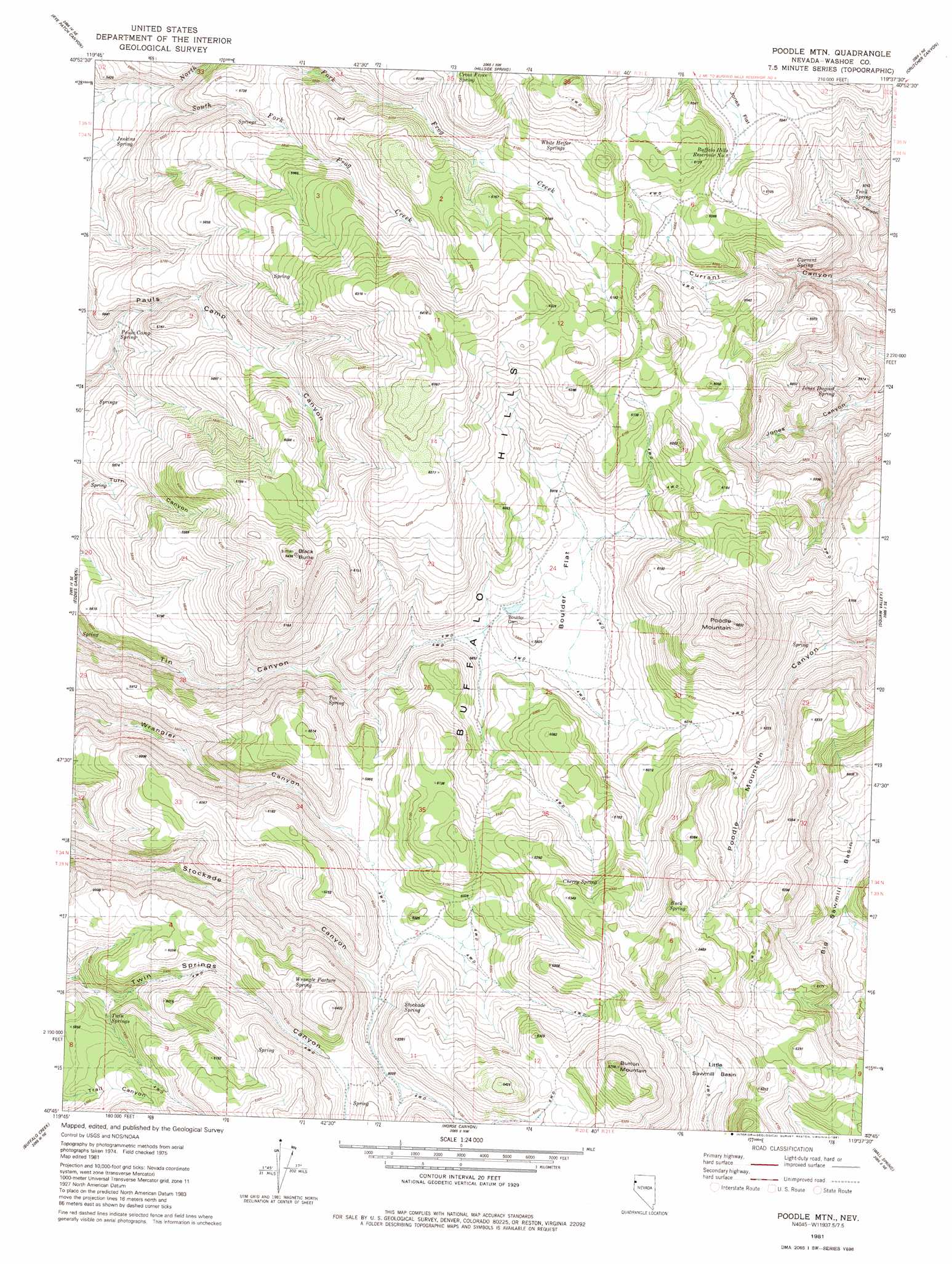
USGS Topo Quad 40119g6 - 1:24,000 scale
| Topo Map Name: | Poodle Mountain |
| USGS Topo Quad ID: | 40119g6 |
| Print Size: | ca. 21 1/4" wide x 27" high |
| Southeast Coordinates: | 40.75° N latitude / 119.625° W longitude |
| Map Center Coordinates: | 40.8125° N latitude / 119.6875° W longitude |
| U.S. State: | NV |
| Filename: | o40119g6.jpg |
| Download Map JPG Image: | Poodle Mountain topo map 1:24,000 scale |
| Map Type: | Topographic |
| Topo Series: | 7.5´ |
| Map Scale: | 1:24,000 |
| Source of Map Images: | United States Geological Survey (USGS) |
| Alternate Map Versions: |
Poodle Mtn NV 1981, updated 1981 Download PDF Buy paper map Poodle Mountain NV 2011 Download PDF Buy paper map Poodle Mountain NV 2014 Download PDF Buy paper map |
1:24,000 Topo Quads surrounding Poodle Mountain
Duck Lake |
Juniper Springs |
Lost Creek Pass |
Fox Mountain |
Leadville |
Burnt Lake |
Rye Patch Canyon |
Hillside Spring |
Crutcher Canyon |
Melody Mountain |
Hole In The Ground |
Eddies Garden |
Poodle Mountain |
Squaw Valley |
The Banjo |
Mixie Flat |
Buffalo Creek |
Horse Canyon |
Wall Spring |
Godeys Rock |
Smoke Creek Ranch |
Salt Marsh |
Hog Spring |
Smith Canyon |
West Of Empire |
> Back to 40119e1 at 1:100,000 scale
> Back to 40118a1 at 1:250,000 scale
> Back to U.S. Topo Maps home
Poodle Mountain topo map: Gazetteer
Poodle Mountain: Basins
Big Sawmill Basin elevation 1788m 5866′Little Sawmill Basin elevation 1811m 5941′
Poodle Mountain: Dams
Boulder Dam elevation 1781m 5843′Poodle Mountain: Flats
Boulder Flat elevation 1788m 5866′Poodle Mountain: Ranges
Buffalo Hills elevation 1902m 6240′Poodle Mountain: Reservoirs
Boulder Dam Reservoir elevation 1781m 5843′Buffalo Hills Reservoir Number 8 elevation 1837m 6026′
Jones Flat Reservoir elevation 1826m 5990′
Poodle Mountain: Springs
Black Mountain Spring elevation 1688m 5538′Buck Spring elevation 1946m 6384′
Cherry Spring elevation 1899m 6230′
Cross Fence Spring elevation 1878m 6161′
Currant Spring elevation 1752m 5748′
Hillside Spring elevation 1895m 6217′
Jenkins Spring elevation 1626m 5334′
Jones Dugout Spring elevation 1665m 5462′
Pauls Camp Spring elevation 1659m 5442′
Stockade Spring elevation 1883m 6177′
Tin Spring elevation 1817m 5961′
Trail Spring elevation 1717m 5633′
Trough Spring elevation 1866m 6122′
Twin Springs elevation 1767m 5797′
White Heifer Springs elevation 1880m 6167′
Wrangle Pasture Spring elevation 1906m 6253′
Poodle Mountain: Streams
North Fork Frog Creek elevation 1610m 5282′South Fork Frog Creek elevation 1610m 5282′
Poodle Mountain: Summits
Black Butte elevation 1956m 6417′Button Mountain elevation 2036m 6679′
Poodle Mountain elevation 2043m 6702′
Poodle Mountain digital topo map on disk
Buy this Poodle Mountain topo map showing relief, roads, GPS coordinates and other geographical features, as a high-resolution digital map file on DVD: