Genesee Valley Topo Map California
To zoom in, hover over the map of Genesee Valley
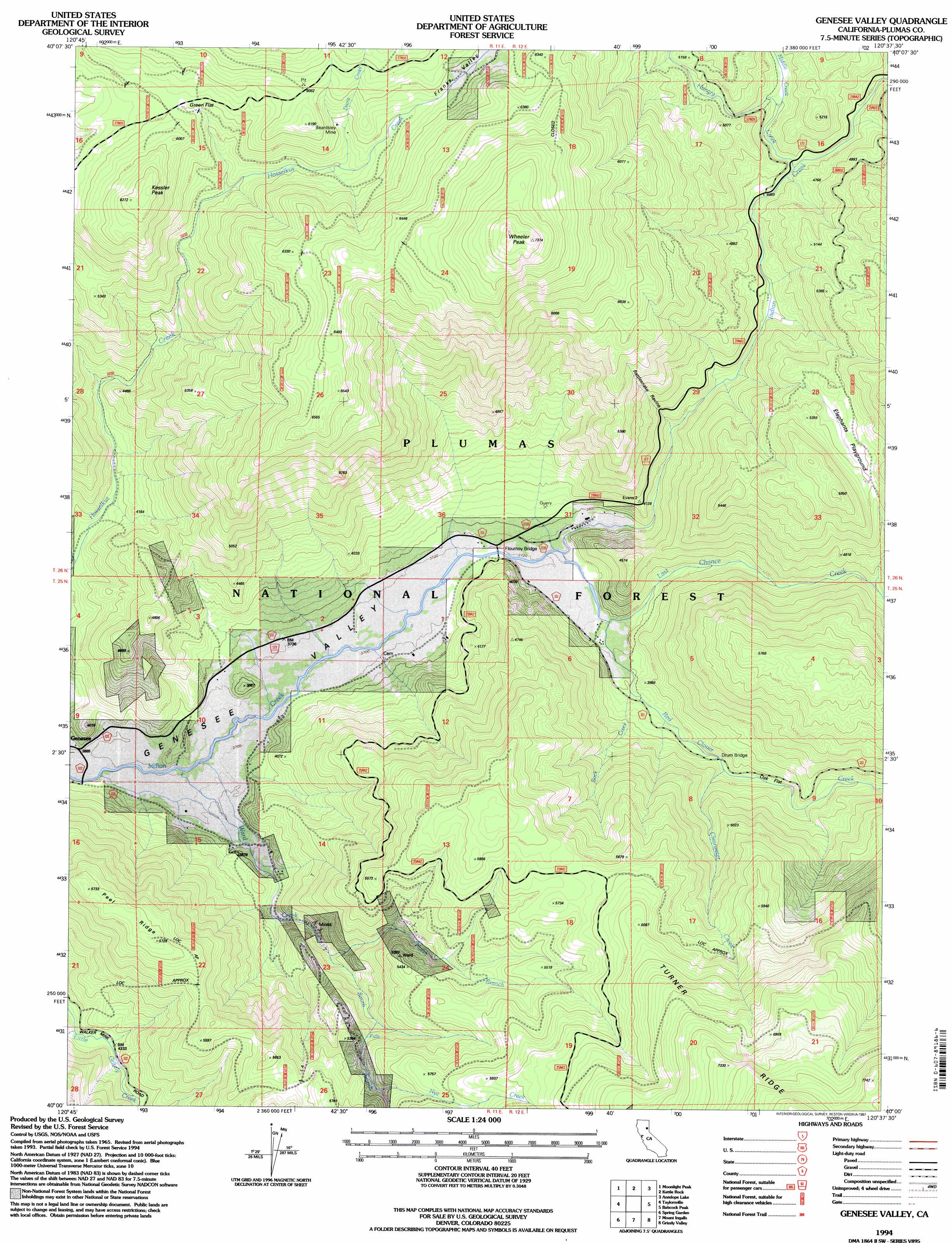
USGS Topo Quad 40120a6 - 1:24,000 scale
| Topo Map Name: | Genesee Valley |
| USGS Topo Quad ID: | 40120a6 |
| Print Size: | ca. 21 1/4" wide x 27" high |
| Southeast Coordinates: | 40° N latitude / 120.625° W longitude |
| Map Center Coordinates: | 40.0625° N latitude / 120.6875° W longitude |
| U.S. State: | CA |
| Filename: | o40120a6.jpg |
| Download Map JPG Image: | Genesee Valley topo map 1:24,000 scale |
| Map Type: | Topographic |
| Topo Series: | 7.5´ |
| Map Scale: | 1:24,000 |
| Source of Map Images: | United States Geological Survey (USGS) |
| Alternate Map Versions: |
Genesee Valley CA 1972, updated 1974 Download PDF Buy paper map Genesee Valley CA 1994, updated 1997 Download PDF Buy paper map Genesee Valley CA 1994, updated 1997 Download PDF Buy paper map Genesee Valley CA 2012 Download PDF Buy paper map Genesee Valley CA 2015 Download PDF Buy paper map |
| FStopo: | US Forest Service topo Genesee Valley is available: Download FStopo PDF Download FStopo TIF |
1:24,000 Topo Quads surrounding Genesee Valley
Westwood East |
Fredonyer Pass |
Diamond Mountain |
Janesville |
Standish |
Greenville |
Moonlight Peak |
Kettle Rock |
Antelope Lake |
Stony Ridge |
Crescent Mills |
Taylorsville |
Genesee Valley |
Babcock Peak |
Squaw Valley Peak |
Quincy |
Spring Garden |
Mount Ingalls |
Grizzly Valley |
Crocker Mountain |
Onion Valley |
Blue Nose Mountain |
Johnsville |
Blairsden |
Portola |
> Back to 40120a1 at 1:100,000 scale
> Back to 40120a1 at 1:250,000 scale
> Back to U.S. Topo Maps home
Genesee Valley topo map: Gazetteer
Genesee Valley: Areas
Elephants Playground elevation 1577m 5173′Genesee Valley: Bridges
Drum Bridge elevation 1224m 4015′Flournoy Bridge elevation 1132m 3713′
Genesee Valley: Flats
Green Flat elevation 1769m 5803′Oak Flat elevation 1249m 4097′
Genesee Valley: Forests
Plumas National Forest elevation 2029m 6656′Genesee Valley: Mines
Beardsley Mine elevation 1778m 5833′Genesee Valley: Ridges
Peel Ridge elevation 1730m 5675′Genesee Valley: Streams
Clearwater Creek elevation 1236m 4055′Davis Creek elevation 1711m 5613′
Hungry Creek elevation 1372m 4501′
Last Chance Creek elevation 1134m 3720′
Middle Creek elevation 1403m 4603′
North Branch Ward Creek elevation 1292m 4238′
Nye Creek elevation 1616m 5301′
Red Clover Creek elevation 1141m 3743′
Rock Creek elevation 1162m 3812′
South Branch Ward Creek elevation 1292m 4238′
Ward Creek elevation 1122m 3681′
Genesee Valley: Summits
Kessler Peak elevation 1925m 6315′Wheeler Peak elevation 2220m 7283′
Genesee Valley: Valleys
Franks Valley elevation 1708m 5603′Rattlesnake Ravine elevation 1248m 4094′
Genesee Valley digital topo map on disk
Buy this Genesee Valley topo map showing relief, roads, GPS coordinates and other geographical features, as a high-resolution digital map file on DVD: