Antelope Mountain Topo Map California
To zoom in, hover over the map of Antelope Mountain
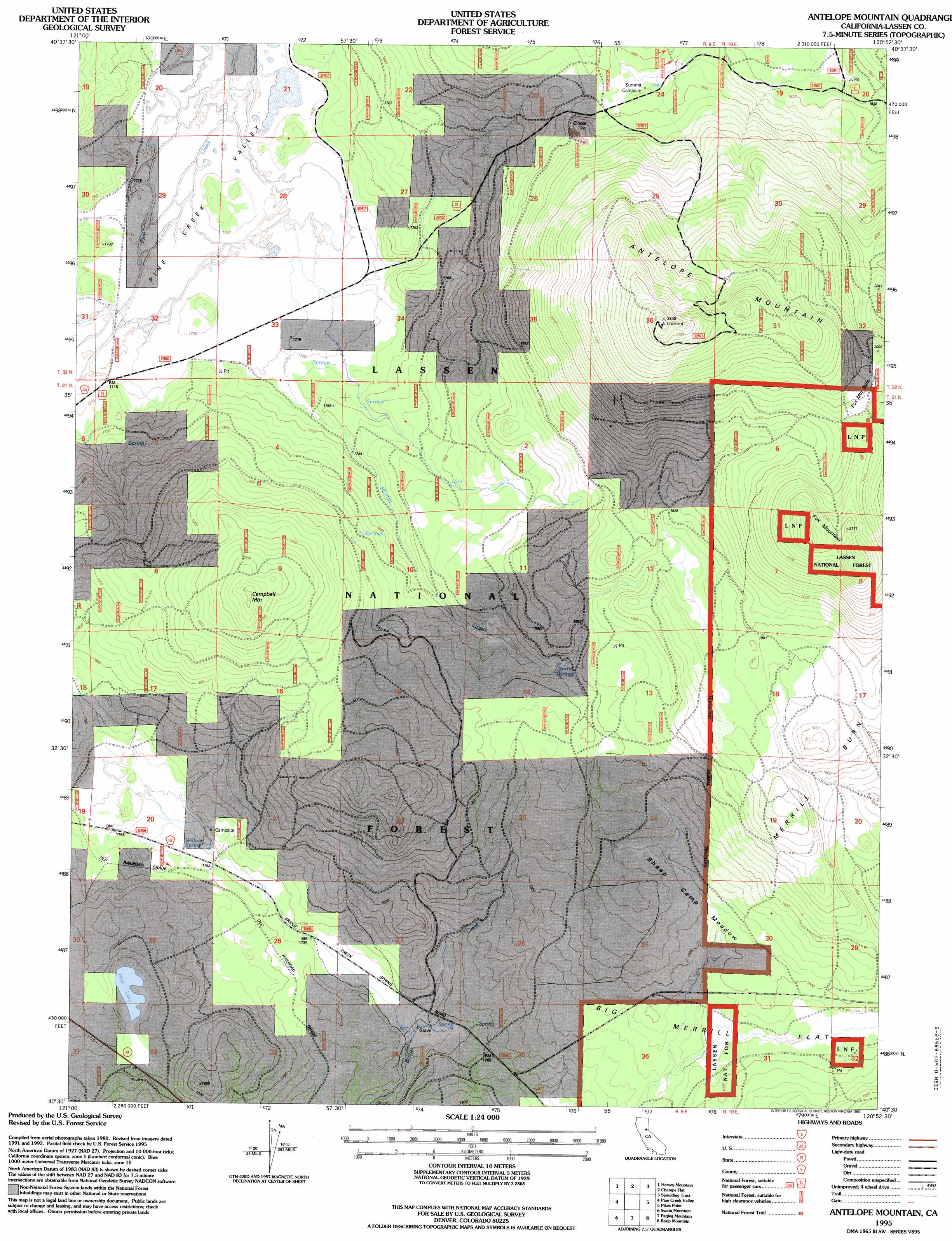
USGS Topo Quad 40120e8 - 1:24,000 scale
| Topo Map Name: | Antelope Mountain |
| USGS Topo Quad ID: | 40120e8 |
| Print Size: | ca. 21 1/4" wide x 27" high |
| Southeast Coordinates: | 40.5° N latitude / 120.875° W longitude |
| Map Center Coordinates: | 40.5625° N latitude / 120.9375° W longitude |
| U.S. State: | CA |
| Filename: | o40120e8.jpg |
| Download Map JPG Image: | Antelope Mountain topo map 1:24,000 scale |
| Map Type: | Topographic |
| Topo Series: | 7.5´ |
| Map Scale: | 1:24,000 |
| Source of Map Images: | United States Geological Survey (USGS) |
| Alternate Map Versions: |
Antelope Mtn CA 1983, updated 1983 Download PDF Buy paper map Antelope Mountain CA 1995, updated 1997 Download PDF Buy paper map Antelope Mountain CA 2012 Download PDF Buy paper map Antelope Mountain CA 2015 Download PDF Buy paper map |
| FStopo: | US Forest Service topo Antelope Mountain is available: Download FStopo PDF Download FStopo TIF |
1:24,000 Topo Quads surrounding Antelope Mountain
Corders Reservoir |
Straylor Lake |
Bullard Lake |
Sheepshead |
Grasshopper Valley |
Poison Lake |
Harvey Mountain |
Champs Flat |
Spalding Tract |
Troxel Point |
Bogard Buttes |
Pine Creek Valley |
Antelope Mountain |
Pikes Point |
Gallatin Peak |
Red Cinder |
Swain Mountain |
Pegleg Mountain |
Roop Mountain |
Susanville |
Chester |
Westwood West |
Westwood East |
Fredonyer Pass |
Diamond Mountain |
> Back to 40120e1 at 1:100,000 scale
> Back to 40120a1 at 1:250,000 scale
> Back to U.S. Topo Maps home
Antelope Mountain topo map: Gazetteer
Antelope Mountain: Areas
Fox Mountain Burn elevation 2104m 6902′Antelope Mountain: Flats
Big Merrill Flat elevation 1795m 5889′Sheep Camp Meadow elevation 1811m 5941′
Antelope Mountain: Lakes
Mud Lake elevation 1767m 5797′Antelope Mountain: Springs
Martin Springs elevation 1831m 6007′Willow Spring elevation 1751m 5744′
Antelope Mountain: Streams
Martin Creek elevation 1717m 5633′Antelope Mountain: Summits
Antelope Mountain elevation 2326m 7631′Campbell Mountain elevation 2052m 6732′
Fox Mountain elevation 2161m 7089′
Antelope Mountain digital topo map on disk
Buy this Antelope Mountain topo map showing relief, roads, GPS coordinates and other geographical features, as a high-resolution digital map file on DVD: