West Of Snowstorm Mountain Topo Map California
To zoom in, hover over the map of West Of Snowstorm Mountain
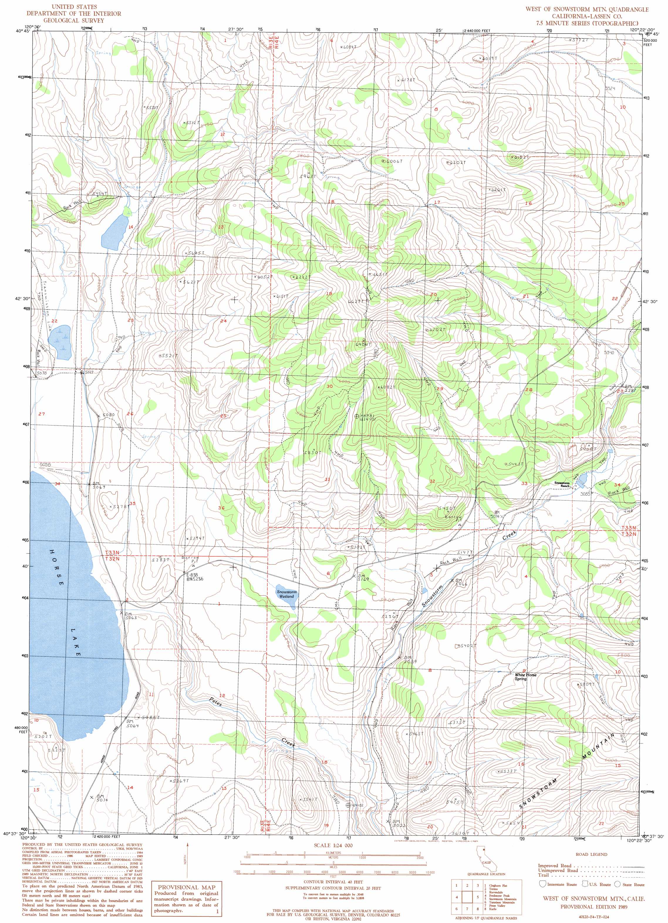
USGS Topo Quad 40120f4 - 1:24,000 scale
| Topo Map Name: | West Of Snowstorm Mountain |
| USGS Topo Quad ID: | 40120f4 |
| Print Size: | ca. 21 1/4" wide x 27" high |
| Southeast Coordinates: | 40.625° N latitude / 120.375° W longitude |
| Map Center Coordinates: | 40.6875° N latitude / 120.4375° W longitude |
| U.S. State: | CA |
| Filename: | o40120f4.jpg |
| Download Map JPG Image: | West Of Snowstorm Mountain topo map 1:24,000 scale |
| Map Type: | Topographic |
| Topo Series: | 7.5´ |
| Map Scale: | 1:24,000 |
| Source of Map Images: | United States Geological Survey (USGS) |
| Alternate Map Versions: |
West of Snowstorm Mtn CA 1989, updated 1989 Download PDF Buy paper map West of Snowstorm Mountain CA 2012 Download PDF Buy paper map West of Snowstorm Mountain CA 2015 Download PDF Buy paper map |
1:24,000 Topo Quads surrounding West Of Snowstorm Mountain
Whitinger Mountain |
Anderson Mountain |
Mcdonald Peak |
Juniper Ridge |
Dodge Reservoir |
Grasshopper Valley |
Cleghorn Flat |
Termo |
Ravendale |
Observation Peak |
Troxel Point |
Fredonyer Peak |
West Of Snowstorm Mountain |
Snowstorm Mountain |
Shinn Mountain |
Gallatin Peak |
Tunnison Mountain |
Petes Valley |
Karlo |
Five Springs |
Susanville |
Johnstonville |
Litchfield |
Shaffer Mountain |
Little Mud Flat |
> Back to 40120e1 at 1:100,000 scale
> Back to 40120a1 at 1:250,000 scale
> Back to U.S. Topo Maps home
West Of Snowstorm Mountain topo map: Gazetteer
West Of Snowstorm Mountain: Dams
Coon Camp 249 Dam elevation 1583m 5193′Horse Lake 245 Dam elevation 1557m 5108′
West Of Snowstorm Mountain: Populated Places
Horse Lake elevation 1552m 5091′Shumway elevation 1548m 5078′
West Of Snowstorm Mountain: Springs
White Horse Spring elevation 1650m 5413′West Of Snowstorm Mountain: Swamps
Snowstorm Wetland elevation 1578m 5177′West Of Snowstorm Mountain digital topo map on disk
Buy this West Of Snowstorm Mountain topo map showing relief, roads, GPS coordinates and other geographical features, as a high-resolution digital map file on DVD: