Bullard Lake Topo Map California
To zoom in, hover over the map of Bullard Lake
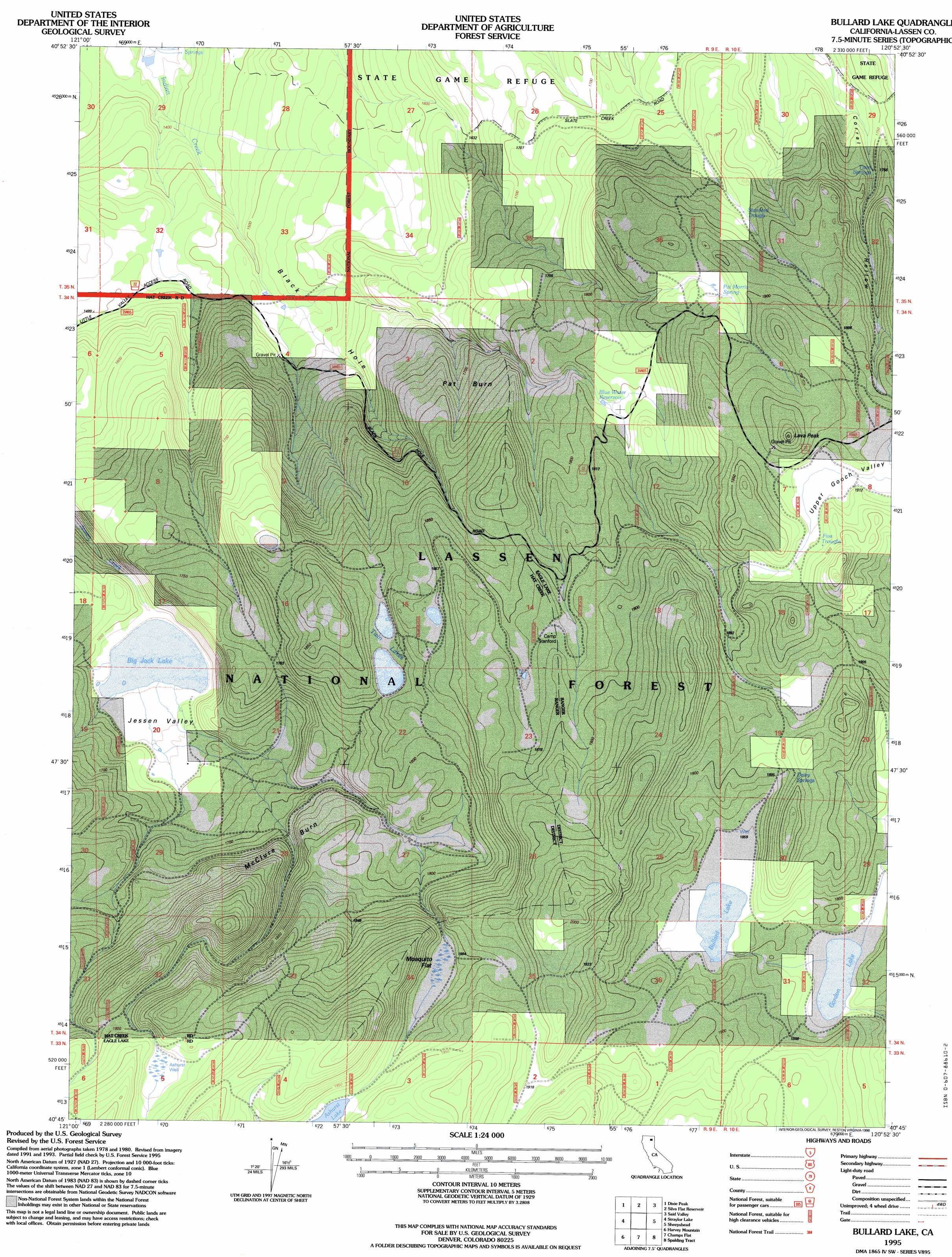
USGS Topo Quad 40120g8 - 1:24,000 scale
| Topo Map Name: | Bullard Lake |
| USGS Topo Quad ID: | 40120g8 |
| Print Size: | ca. 21 1/4" wide x 27" high |
| Southeast Coordinates: | 40.75° N latitude / 120.875° W longitude |
| Map Center Coordinates: | 40.8125° N latitude / 120.9375° W longitude |
| U.S. State: | CA |
| Filename: | o40120g8.jpg |
| Download Map JPG Image: | Bullard Lake topo map 1:24,000 scale |
| Map Type: | Topographic |
| Topo Series: | 7.5´ |
| Map Scale: | 1:24,000 |
| Source of Map Images: | United States Geological Survey (USGS) |
| Alternate Map Versions: |
Bullard Lake CA 1983, updated 1983 Download PDF Buy paper map Bullard Lake CA 1995, updated 1998 Download PDF Buy paper map Bullard Lake CA 2012 Download PDF Buy paper map Bullard Lake CA 2015 Download PDF Buy paper map |
| FStopo: | US Forest Service topo Bullard Lake is available: Download FStopo PDF Download FStopo TIF |
1:24,000 Topo Quads surrounding Bullard Lake
Bieber |
Hog Valley |
Letterbox Hill |
Lane Reservoir |
Ash Valley |
Little Valley |
Dixie Peak |
Silva Flat Reservoir |
Said Valley |
Whitinger Mountain |
Corders Reservoir |
Straylor Lake |
Bullard Lake |
Sheepshead |
Grasshopper Valley |
Poison Lake |
Harvey Mountain |
Champs Flat |
Spalding Tract |
Troxel Point |
Bogard Buttes |
Pine Creek Valley |
Antelope Mountain |
Pikes Point |
Gallatin Peak |
> Back to 40120e1 at 1:100,000 scale
> Back to 40120a1 at 1:250,000 scale
> Back to U.S. Topo Maps home
Bullard Lake topo map: Gazetteer
Bullard Lake: Areas
McClure Burn elevation 1715m 5626′Pat Burn elevation 1724m 5656′
Bullard Lake: Flats
Mosquito Flat elevation 1884m 6181′Bullard Lake: Lakes
Big Jack Lake elevation 1625m 5331′Blue Water elevation 1793m 5882′
Bullard Lake elevation 1857m 6092′
Dry Lake elevation 1796m 5892′
Gordon Lake elevation 1827m 5994′
Twin Lakes elevation 1808m 5931′
Bullard Lake: Springs
Dairy Spring elevation 1919m 6295′Five Troughs elevation 1922m 6305′
Pat Morris Spring elevation 1869m 6131′
Stanford Trough elevation 1817m 5961′
Twin Springs elevation 1774m 5820′
Bullard Lake: Summits
Lava Peak elevation 1990m 6528′Bullard Lake: Valleys
Black Hole elevation 1391m 4563′Clover Valley elevation 1835m 6020′
Jessen Valley elevation 1630m 5347′
Bullard Lake: Wells
Ashurst Well elevation 1917m 6289′Bullard Lake digital topo map on disk
Buy this Bullard Lake topo map showing relief, roads, GPS coordinates and other geographical features, as a high-resolution digital map file on DVD: