Devils Parade Ground Topo Map California
To zoom in, hover over the map of Devils Parade Ground
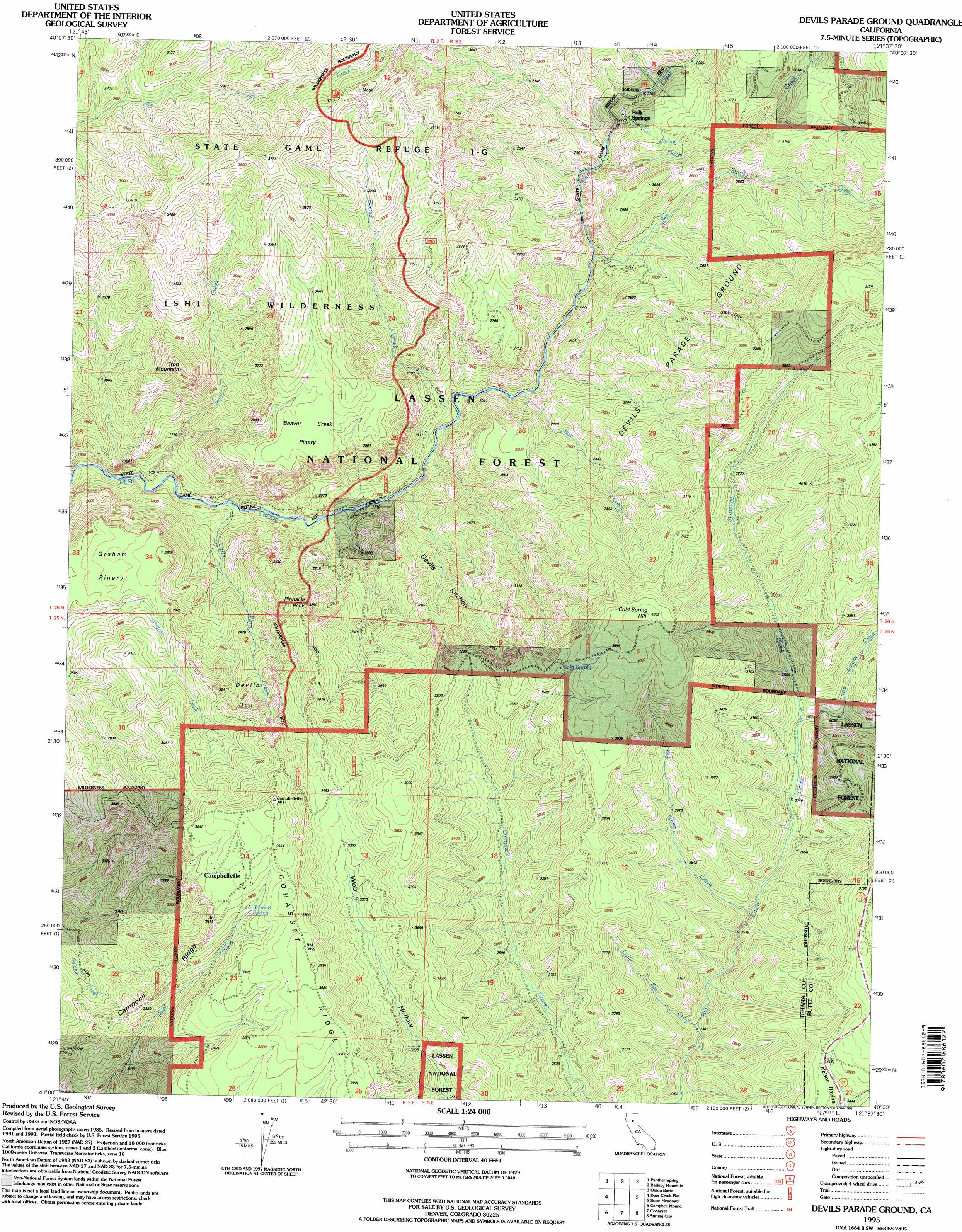
USGS Topo Quad 40121a6 - 1:24,000 scale
| Topo Map Name: | Devils Parade Ground |
| USGS Topo Quad ID: | 40121a6 |
| Print Size: | ca. 21 1/4" wide x 27" high |
| Southeast Coordinates: | 40° N latitude / 121.625° W longitude |
| Map Center Coordinates: | 40.0625° N latitude / 121.6875° W longitude |
| U.S. State: | CA |
| Filename: | o40121a6.jpg |
| Download Map JPG Image: | Devils Parade Ground topo map 1:24,000 scale |
| Map Type: | Topographic |
| Topo Series: | 7.5´ |
| Map Scale: | 1:24,000 |
| Source of Map Images: | United States Geological Survey (USGS) |
| Alternate Map Versions: |
Devils Parade Ground CA 1991, updated 1991 Download PDF Buy paper map Devils Parade Ground CA 1995, updated 1998 Download PDF Buy paper map Devils Parade Ground CA 2012 Download PDF Buy paper map Devils Parade Ground CA 2015 Download PDF Buy paper map |
| FStopo: | US Forest Service topo Devils Parade Ground is available: Download FStopo PDF Download FStopo TIF |
1:24,000 Topo Quads surrounding Devils Parade Ground
Inskip Hill |
Finley Butte |
Lyonsville |
Mineral |
Childs Meadows |
Dewitt Peak |
Panther Spring |
Barkley Mountain |
Onion Butte |
Humboldt Peak |
Acorn Hollow |
Ishi Caves |
Devils Parade Ground |
Butte Meadows |
Jonesville |
Richardson Springs Nw |
Campbell Mound |
Cohasset |
Stirling City |
Kimshew Point |
Nord |
Richardson Springs |
Paradise West |
Paradise East |
Pulga |
> Back to 40121a1 at 1:100,000 scale
> Back to 40120a1 at 1:250,000 scale
> Back to U.S. Topo Maps home
Devils Parade Ground topo map: Gazetteer
Devils Parade Ground: Areas
Devils Kitchen elevation 733m 2404′Devils Parade Ground elevation 823m 2700′
Devils Parade Ground: Basins
Devils Den elevation 995m 3264′Devils Parade Ground: Flats
Beaver Creek Pinery elevation 976m 3202′Devils Parade Ground: Populated Places
Campbellville elevation 1187m 3894′Polk Springs elevation 751m 2463′
Devils Parade Ground: Ridges
Campbell Ridge elevation 973m 3192′Devils Parade Ground: Springs
Bennett Spring elevation 1139m 3736′Cold Spring elevation 1151m 3776′
Devils Parade Ground: Streams
Bear Creek elevation 584m 1916′Beaver Creek elevation 567m 1860′
Big Bear Creek elevation 821m 2693′
Big Smoky Creek elevation 632m 2073′
Ditch Creek elevation 656m 2152′
Iron Creek elevation 463m 1519′
Little Bear Creek elevation 731m 2398′
Little Pine Creek elevation 486m 1594′
Little Smoky Creek elevation 865m 2837′
Ninemile Creek elevation 853m 2798′
Devils Parade Ground: Summits
Cold Spring Hill elevation 1239m 4064′Iron Mountain elevation 982m 3221′
Pinnacle Peak elevation 988m 3241′
Devils Parade Ground: Trails
Graham Trail (historical) elevation 464m 1522′Murphy Trail (historical) elevation 877m 2877′
Devils Parade Ground digital topo map on disk
Buy this Devils Parade Ground topo map showing relief, roads, GPS coordinates and other geographical features, as a high-resolution digital map file on DVD: