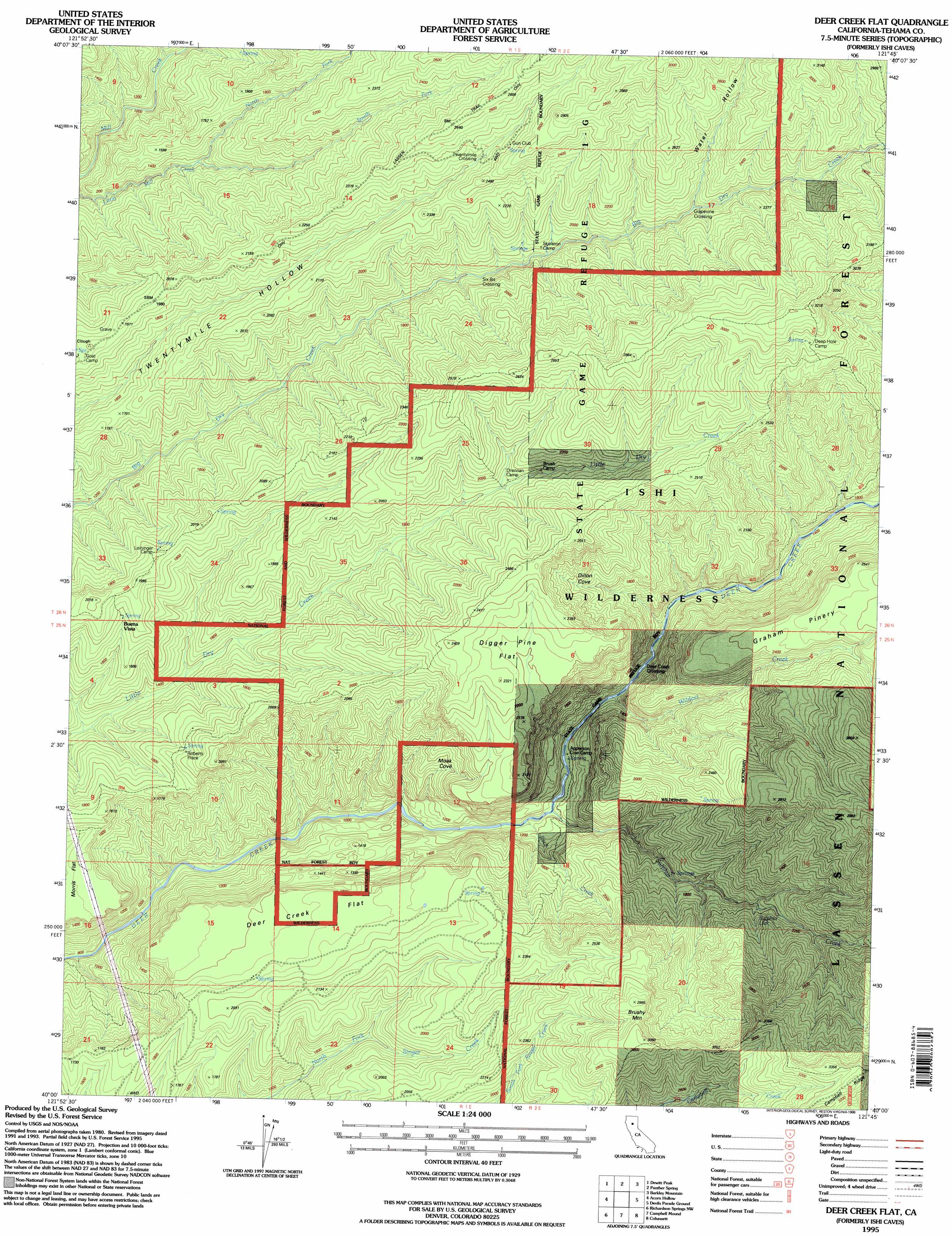
Ishi Caves Topo Map California
To zoom in, hover over the map of Ishi Caves
USGS Topo Quad 40121a7 - 1:24,000 scale
| Topo Map Name: | Ishi Caves |
| USGS Topo Quad ID: | 40121a7 |
| Print Size: | ca. 21 1/4" wide x 27" high |
| Southeast Coordinates: | 40° N latitude / 121.75° W longitude |
| Map Center Coordinates: | 40.0625° N latitude / 121.8125° W longitude |
| U.S. State: | CA |
| Filename: | o40121a7.jpg |
| Download Map JPG Image: | Ishi Caves topo map 1:24,000 scale |
| Map Type: | Topographic |
| Topo Series: | 7.5´ |
| Map Scale: | 1:24,000 |
| Source of Map Images: | United States Geological Survey (USGS) |
| Alternate Map Versions: |
Ishi Caves CA 1986, updated 1986 Download PDF Buy paper map Ishi Caves CA 1986, updated 1986 Download PDF Buy paper map Digger Pine Flat CA 1986, updated 1996 Download PDF Buy paper map Digger Pine Flat CA 1986, updated 1996 Download PDF Buy paper map Deer Creek Flat CA 1995, updated 1998 Download PDF Buy paper map Deer Creek Flat CA 2012 Download PDF Buy paper map Deer Creek Flat CA 2015 Download PDF Buy paper map |
| FStopo: | US Forest Service topo Deer Creek Flat is available: Download FStopo PDF Download FStopo TIF |
1:24,000 Topo Quads surrounding Ishi Caves
Dales |
Inskip Hill |
Finley Butte |
Lyonsville |
Mineral |
Tuscan Springs |
Dewitt Peak |
Panther Spring |
Barkley Mountain |
Onion Butte |
Los Molinos |
Acorn Hollow |
Ishi Caves |
Devils Parade Ground |
Butte Meadows |
Vina |
Richardson Springs Nw |
Campbell Mound |
Cohasset |
Stirling City |
Foster Island |
Nord |
Richardson Springs |
Paradise West |
Paradise East |
> Back to 40121a1 at 1:100,000 scale
> Back to 40120a1 at 1:250,000 scale
> Back to U.S. Topo Maps home
Ishi Caves topo map: Gazetteer
Ishi Caves: Crossings
Deer Creek Crossing elevation 455m 1492′Grapevine Crossing elevation 642m 2106′
Six-Bit Crossing elevation 515m 1689′
Twentymile Crossing elevation 744m 2440′
Ishi Caves: Flats
Deer Creek Flat elevation 573m 1879′Digger Pine Flat elevation 672m 2204′
Ishi Caves: Pillars
Steamboat Rock elevation 798m 2618′Ishi Caves: Populated Places
Buena Vista elevation 528m 1732′Roberts Place elevation 536m 1758′
Ishi Caves: Springs
Sulphur Lick elevation 604m 1981′Ishi Caves: Streams
North Fork Little Mill Creek elevation 415m 1361′Rock Creek elevation 340m 1115′
South Fork Little Mill Creek elevation 429m 1407′
Sulphur Creek elevation 345m 1131′
Wildcat Creek elevation 370m 1213′
Ishi Caves: Summits
Brushy Mountain elevation 928m 3044′Ishi Caves: Trails
Buena Vista Trail elevation 600m 1968′Moak Trail (historical) elevation 607m 1991′
Old Lassen Trail elevation 831m 2726′
Steamboat Trail elevation 819m 2687′
Ishi Caves: Valleys
Dillion Cove elevation 468m 1535′Moak Cove elevation 628m 2060′
Water Hollow elevation 625m 2050′
Ishi Caves: Woods
Graham Pinery elevation 788m 2585′Ishi Caves digital topo map on disk
Buy this Ishi Caves topo map showing relief, roads, GPS coordinates and other geographical features, as a high-resolution digital map file on DVD: