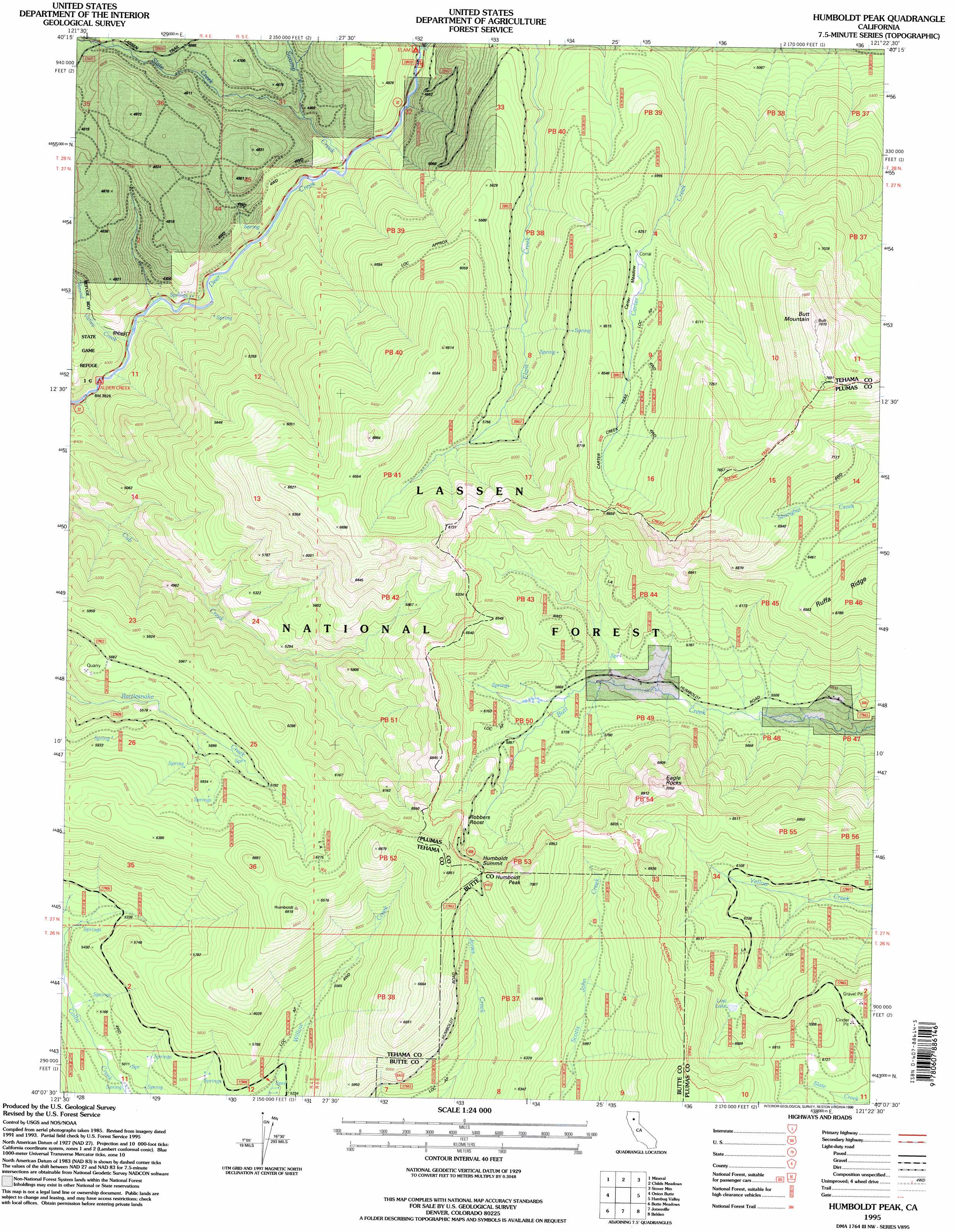
Humboldt Peak Topo Map California
To zoom in, hover over the map of Humboldt Peak
USGS Topo Quad 40121b4 - 1:24,000 scale
| Topo Map Name: | Humboldt Peak |
| USGS Topo Quad ID: | 40121b4 |
| Print Size: | ca. 21 1/4" wide x 27" high |
| Southeast Coordinates: | 40.125° N latitude / 121.375° W longitude |
| Map Center Coordinates: | 40.1875° N latitude / 121.4375° W longitude |
| U.S. State: | CA |
| Filename: | o40121b4.jpg |
| Download Map JPG Image: | Humboldt Peak topo map 1:24,000 scale |
| Map Type: | Topographic |
| Topo Series: | 7.5´ |
| Map Scale: | 1:24,000 |
| Source of Map Images: | United States Geological Survey (USGS) |
| Alternate Map Versions: |
Humboldt Peak CA 1991, updated 1991 Download PDF Buy paper map Humboldt Peak CA 1995, updated 1998 Download PDF Buy paper map Humboldt Peak CA 2012 Download PDF Buy paper map Humboldt Peak CA 2015 Download PDF Buy paper map |
| FStopo: | US Forest Service topo Humboldt Peak is available: Download FStopo PDF Download FStopo TIF |
1:24,000 Topo Quads surrounding Humboldt Peak
Grays Peak |
Lassen Peak |
Reading Peak |
Mount Harkness |
Red Cinder |
Lyonsville |
Mineral |
Childs Meadows |
Stover Mountain |
Chester |
Barkley Mountain |
Onion Butte |
Humboldt Peak |
Humbug Valley |
Almanor |
Devils Parade Ground |
Butte Meadows |
Jonesville |
Belden |
Caribou |
Cohasset |
Stirling City |
Kimshew Point |
Storrie |
Bucks Lake |
> Back to 40121a1 at 1:100,000 scale
> Back to 40120a1 at 1:250,000 scale
> Back to U.S. Topo Maps home
Humboldt Peak topo map: Gazetteer
Humboldt Peak: Flats
Carter Meadow elevation 1916m 6286′Humboldt Peak: Lakes
Lost Lake elevation 1969m 6459′Humboldt Peak: Streams
Elam Creek elevation 1335m 4379′Round Valley Creek elevation 1203m 3946′
Slate Creek elevation 1296m 4251′
Swamp Creek elevation 1347m 4419′
Humboldt Peak: Summits
Butt Mountain elevation 2395m 7857′Eagle Rocks elevation 2149m 7050′
Humboldt Peak elevation 2147m 7043′
Humboldt Summit elevation 2085m 6840′
Humboldt Peak: Trails
Carter Creek Trail elevation 1932m 6338′Carter Meadow Trail (historical) elevation 1963m 6440′
Humboldt Peak: Valleys
Round Valley elevation 1193m 3914′Humboldt Peak digital topo map on disk
Buy this Humboldt Peak topo map showing relief, roads, GPS coordinates and other geographical features, as a high-resolution digital map file on DVD: