Onion Butte Topo Map California
To zoom in, hover over the map of Onion Butte
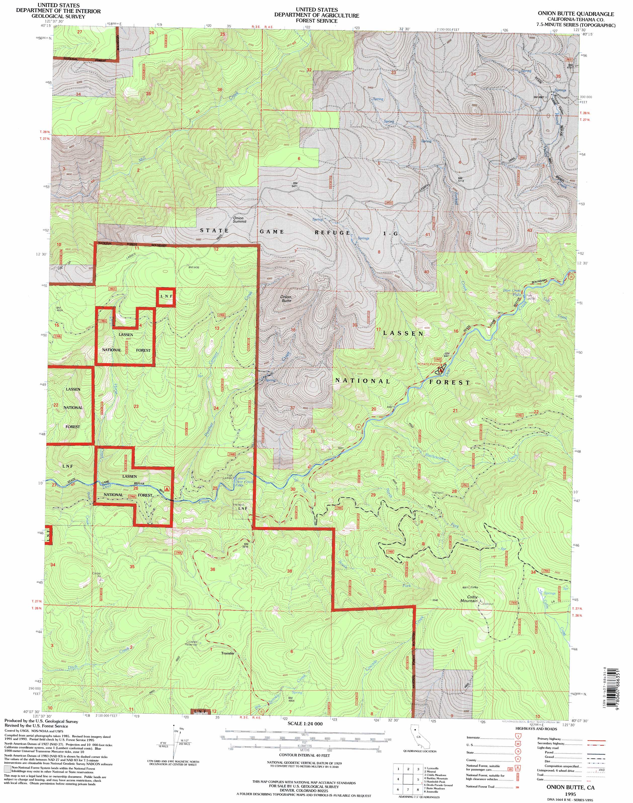
USGS Topo Quad 40121b5 - 1:24,000 scale
| Topo Map Name: | Onion Butte |
| USGS Topo Quad ID: | 40121b5 |
| Print Size: | ca. 21 1/4" wide x 27" high |
| Southeast Coordinates: | 40.125° N latitude / 121.5° W longitude |
| Map Center Coordinates: | 40.1875° N latitude / 121.5625° W longitude |
| U.S. State: | CA |
| Filename: | o40121b5.jpg |
| Download Map JPG Image: | Onion Butte topo map 1:24,000 scale |
| Map Type: | Topographic |
| Topo Series: | 7.5´ |
| Map Scale: | 1:24,000 |
| Source of Map Images: | United States Geological Survey (USGS) |
| Alternate Map Versions: |
Onion Butte CA 1991, updated 1991 Download PDF Buy paper map Onion Butte CA 1995, updated 1997 Download PDF Buy paper map Onion Butte CA 2012 Download PDF Buy paper map Onion Butte CA 2015 Download PDF Buy paper map |
| FStopo: | US Forest Service topo Onion Butte is available: Download FStopo PDF Download FStopo TIF |
1:24,000 Topo Quads surrounding Onion Butte
Manton |
Grays Peak |
Lassen Peak |
Reading Peak |
Mount Harkness |
Finley Butte |
Lyonsville |
Mineral |
Childs Meadows |
Stover Mountain |
Panther Spring |
Barkley Mountain |
Onion Butte |
Humboldt Peak |
Humbug Valley |
Ishi Caves |
Devils Parade Ground |
Butte Meadows |
Jonesville |
Belden |
Campbell Mound |
Cohasset |
Stirling City |
Kimshew Point |
Storrie |
> Back to 40121a1 at 1:100,000 scale
> Back to 40120a1 at 1:250,000 scale
> Back to U.S. Topo Maps home
Onion Butte topo map: Gazetteer
Onion Butte: Areas
Potato Patch elevation 1069m 3507′Onion Butte: Falls
Deer Creek Falls elevation 1109m 3638′Lower Deer Creek Falls elevation 963m 3159′
Onion Butte: Streams
Calf Creek elevation 960m 3149′Cement Creek elevation 1120m 3674′
Cub Creek elevation 1132m 3713′
Dead Horse Creek elevation 878m 2880′
Forked Creek elevation 1093m 3585′
North Fork Calf Creek elevation 1009m 3310′
Panther Creek elevation 898m 2946′
Rattlesnake Creek elevation 994m 3261′
Rush Creek elevation 861m 2824′
South Fork Calf Creek elevation 1009m 3310′
Onion Butte: Summits
Colby Mountain elevation 1834m 6017′Onion Butte elevation 1771m 5810′
Onion Summit elevation 1698m 5570′
Onion Butte: Valleys
Round Valley elevation 1448m 4750′Onion Butte digital topo map on disk
Buy this Onion Butte topo map showing relief, roads, GPS coordinates and other geographical features, as a high-resolution digital map file on DVD: