Stover Mountain Topo Map California
To zoom in, hover over the map of Stover Mountain
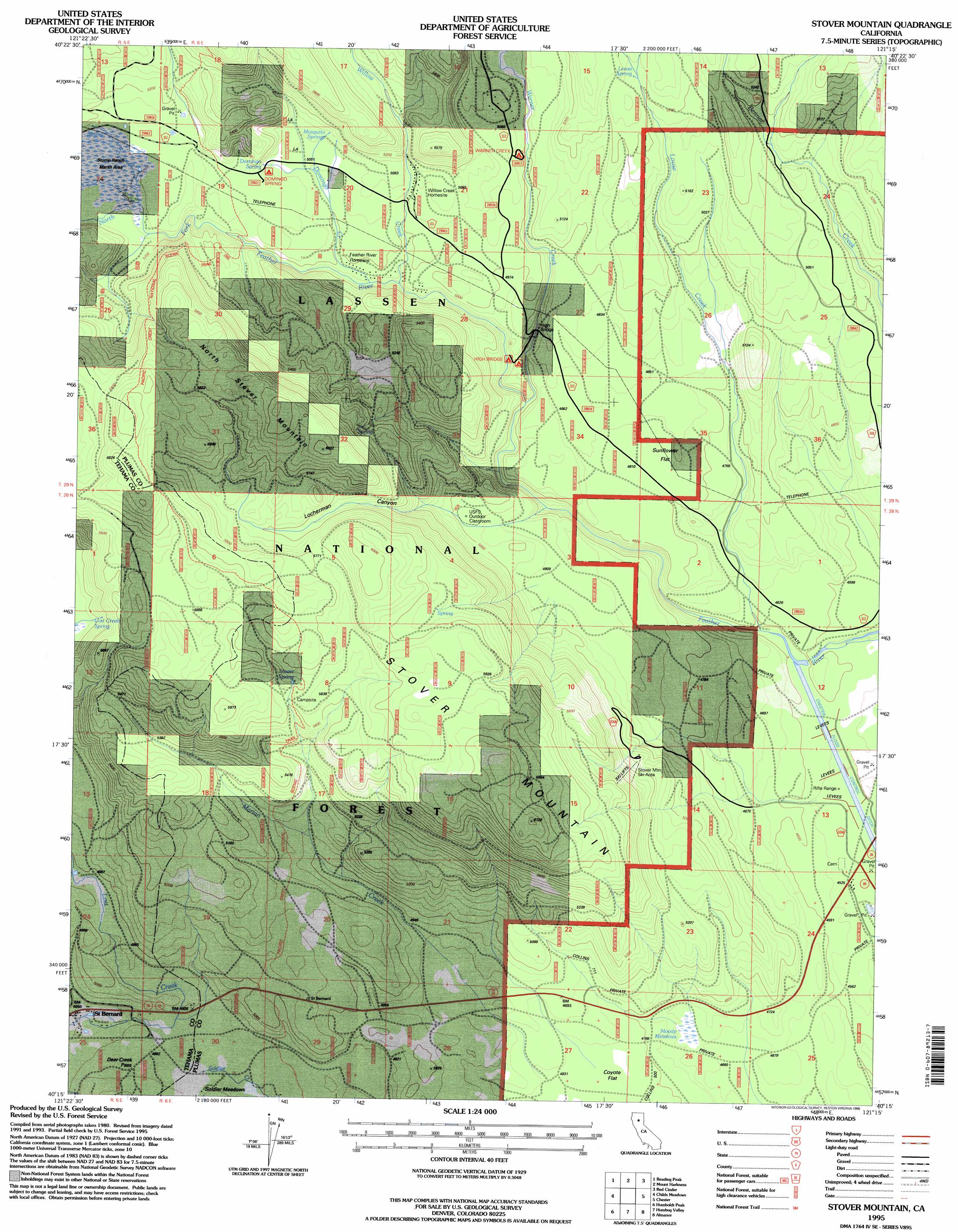
USGS Topo Quad 40121c3 - 1:24,000 scale
| Topo Map Name: | Stover Mountain |
| USGS Topo Quad ID: | 40121c3 |
| Print Size: | ca. 21 1/4" wide x 27" high |
| Southeast Coordinates: | 40.25° N latitude / 121.25° W longitude |
| Map Center Coordinates: | 40.3125° N latitude / 121.3125° W longitude |
| U.S. State: | CA |
| Filename: | o40121c3.jpg |
| Download Map JPG Image: | Stover Mountain topo map 1:24,000 scale |
| Map Type: | Topographic |
| Topo Series: | 7.5´ |
| Map Scale: | 1:24,000 |
| Source of Map Images: | United States Geological Survey (USGS) |
| Alternate Map Versions: |
Stover Mountain CA 1985, updated 1985 Download PDF Buy paper map Stover Mountain CA 1995, updated 1998 Download PDF Buy paper map Stover Mountain CA 2012 Download PDF Buy paper map Stover Mountain CA 2015 Download PDF Buy paper map |
| FStopo: | US Forest Service topo Stover Mountain is available: Download FStopo PDF Download FStopo TIF |
1:24,000 Topo Quads surrounding Stover Mountain
Manzanita Lake |
West Prospect Peak |
Prospect Peak |
Bogard Buttes |
Pine Creek Valley |
Lassen Peak |
Reading Peak |
Mount Harkness |
Red Cinder |
Swain Mountain |
Mineral |
Childs Meadows |
Stover Mountain |
Chester |
Westwood West |
Onion Butte |
Humboldt Peak |
Humbug Valley |
Almanor |
Canyondam |
Butte Meadows |
Jonesville |
Belden |
Caribou |
Twain |
> Back to 40121a1 at 1:100,000 scale
> Back to 40120a1 at 1:250,000 scale
> Back to U.S. Topo Maps home
Stover Mountain topo map: Gazetteer
Stover Mountain: Bridges
High Bridge elevation 1482m 4862′Stover Mountain: Dams
Chester Diversion Dam elevation 1403m 4603′Stover Mountain: Flats
Moody Meadows elevation 1426m 4678′Sunflower Flat elevation 1467m 4812′
Stover Mountain: Gaps
Deer Creek Pass elevation 1501m 4924′Stover Mountain: Populated Places
Saint Bernard elevation 1483m 4865′Stover Mountain: Springs
Domingo Spring elevation 1549m 5082′Lost Creek Spring elevation 1585m 5200′
Louse Spring elevation 1592m 5223′
Mosquito Springs elevation 1557m 5108′
Stover Spring elevation 1729m 5672′
Stover Mountain: Streams
Domingo Creek elevation 1527m 5009′Louse Creek elevation 1400m 4593′
Marian Creek elevation 1488m 4881′
Warner Creek elevation 1455m 4773′
Willow Creek elevation 1500m 4921′
Stover Mountain: Summits
North Stover Mountain elevation 1825m 5987′Old Ski Hill elevation 1468m 4816′
Ski Hill elevation 1566m 5137′
Stover Mountain elevation 1865m 6118′
Stover Mountain: Swamps
Stump Ranch elevation 1567m 5141′Stover Mountain: Valleys
Locherman Canyon elevation 1494m 4901′Warner Valley elevation 1536m 5039′
Stover Mountain digital topo map on disk
Buy this Stover Mountain topo map showing relief, roads, GPS coordinates and other geographical features, as a high-resolution digital map file on DVD: