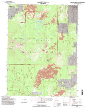
Thousand Lakes Valley Topo Map California
To zoom in, hover over the map of Thousand Lakes Valley
USGS Topo Quad 40121f5 - 1:24,000 scale
| Topo Map Name: | Thousand Lakes Valley |
| USGS Topo Quad ID: | 40121f5 |
| Print Size: | ca. 21 1/4" wide x 27" high |
| Southeast Coordinates: | 40.625° N latitude / 121.5° W longitude |
| Map Center Coordinates: | 40.6875° N latitude / 121.5625° W longitude |
| U.S. State: | CA |
| Filename: | o40121f5.jpg |
| Download Map JPG Image: | Thousand Lakes Valley topo map 1:24,000 scale |
| Map Type: | Topographic |
| Topo Series: | 7.5´ |
| Map Scale: | 1:24,000 |
| Source of Map Images: | United States Geological Survey (USGS) |
| Alternate Map Versions: |
Thousand Lakes Valley CA 1985, updated 1985 Download PDF Buy paper map Thousand Lakes Valley CA 1995, updated 1997 Download PDF Buy paper map Thousand Lakes Valley CA 2012 Download PDF Buy paper map Thousand Lakes Valley CA 2015 Download PDF Buy paper map |
| FStopo: | US Forest Service topo Thousand Lakes Valley is available: Download FStopo PDF Download FStopo TIF |
1:24,000 Topo Quads surrounding Thousand Lakes Valley
> Back to 40121e1 at 1:100,000 scale
> Back to 40120a1 at 1:250,000 scale
> Back to U.S. Topo Maps home
Thousand Lakes Valley topo map: Gazetteer
Thousand Lakes Valley: Areas
Devils Rock Garden elevation 1785m 5856′Thousand Lakes Valley: Basins
Thousand Lakes Valley elevation 1991m 6532′Thousand Lakes Valley: Cliffs
Gray Cliff elevation 2548m 8359′Red Cliff elevation 2360m 7742′
Thousand Lakes Valley: Lakes
Barrett Lake elevation 1966m 6450′Box Lake elevation 1960m 6430′
Durbin Lake elevation 1975m 6479′
Everett Lake elevation 2204m 7230′
Hufford Lake elevation 2061m 6761′
Lake Eiler elevation 1958m 6423′
Lower Twin Lake elevation 2177m 7142′
Magee Lake elevation 2212m 7257′
Mud Lake elevation 1584m 5196′
Upper Twin Lake elevation 2171m 7122′
Thousand Lakes Valley: Springs
Cornaz Spring elevation 1866m 6122′Cornez Spring elevation 1876m 6154′
Wilcox Spring elevation 1644m 5393′
Thousand Lakes Valley: Streams
Bunchgrass Creek elevation 1627m 5337′Thousand Lakes Valley: Summits
Bear Wallow Butte elevation 1875m 6151′Crater Peak elevation 2552m 8372′
Eiler Butte elevation 2048m 6719′
Freaner Peak elevation 2250m 7381′
Fredonyer Peak elevation 2412m 7913′
Hall Butte elevation 2177m 7142′
Little Logan Butte elevation 1832m 6010′
Logan Mountain elevation 2209m 7247′
Magee Peak elevation 2563m 8408′
Tumble Buttes elevation 2024m 6640′
Thousand Lakes Valley: Trails
Bunchgrass Trail elevation 1922m 6305′Cypress Camp Trail elevation 1967m 6453′
Magee Trail elevation 2263m 7424′
Tamarack Swale Trail elevation 1789m 5869′
Wilcox Trail elevation 1553m 5095′
Thousand Lakes Valley: Valleys
Bunchgrass Valley elevation 1584m 5196′Logan Gulch elevation 1591m 5219′
Tamarack Swale elevation 1683m 5521′
Thousand Lakes Valley digital topo map on disk
Buy this Thousand Lakes Valley topo map showing relief, roads, GPS coordinates and other geographical features, as a high-resolution digital map file on DVD:


