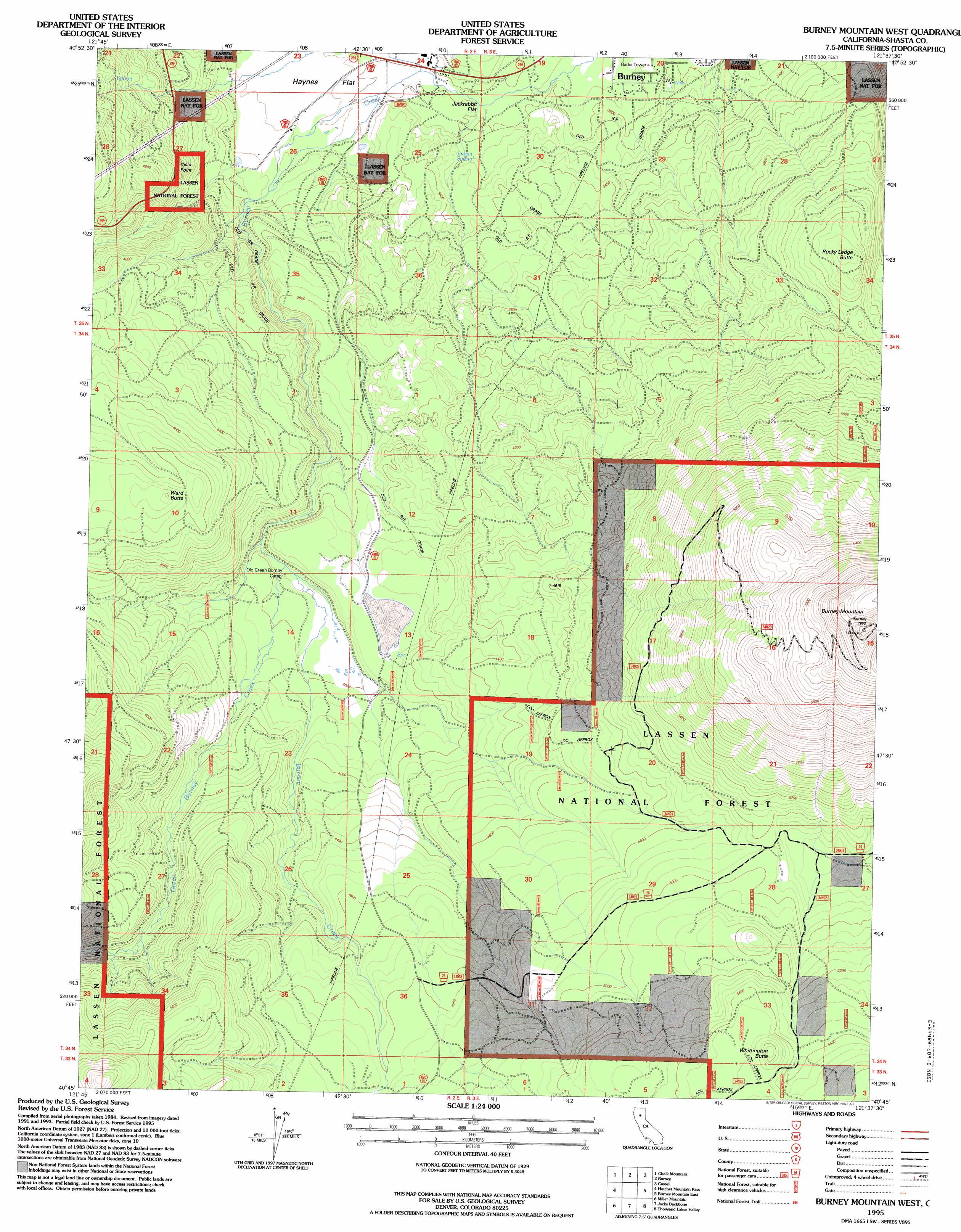
Burney Mountain West Topo Map California
To zoom in, hover over the map of Burney Mountain West
USGS Topo Quad 40121g6 - 1:24,000 scale
| Topo Map Name: | Burney Mountain West |
| USGS Topo Quad ID: | 40121g6 |
| Print Size: | ca. 21 1/4" wide x 27" high |
| Southeast Coordinates: | 40.75° N latitude / 121.625° W longitude |
| Map Center Coordinates: | 40.8125° N latitude / 121.6875° W longitude |
| U.S. State: | CA |
| Filename: | o40121g6.jpg |
| Download Map JPG Image: | Burney Mountain West topo map 1:24,000 scale |
| Map Type: | Topographic |
| Topo Series: | 7.5´ |
| Map Scale: | 1:24,000 |
| Source of Map Images: | United States Geological Survey (USGS) |
| Alternate Map Versions: |
Burney Mountain West CA 1990, updated 1990 Download PDF Buy paper map Burney Mountain West CA 1995, updated 1997 Download PDF Buy paper map Burney Mountain West CA 2012 Download PDF Buy paper map Burney Mountain West CA 2015 Download PDF Buy paper map |
| FStopo: | US Forest Service topo Burney Mountain West is available: Download FStopo PDF Download FStopo TIF |
1:24,000 Topo Quads surrounding Burney Mountain West
Big Bend |
Skunk Ridge |
Burney Falls |
Dana |
Fall River Mills |
Roaring Creek |
Chalk Mountain |
Burney |
Cassel |
Hogback Ridge |
Montgomery Creek |
Hatchet Mountain Pass |
Burney Mountain West |
Burney Mountain East |
Murken Bench |
Whitmore |
Miller Mountain |
Jacks Backbone |
Thousand Lakes Valley |
Old Station |
Inwood |
Hagaman Gulch |
Viola |
Manzanita Lake |
West Prospect Peak |
> Back to 40121e1 at 1:100,000 scale
> Back to 40120a1 at 1:250,000 scale
> Back to U.S. Topo Maps home
Burney Mountain West topo map: Gazetteer
Burney Mountain West: Flats
Haynes Flat elevation 994m 3261′Jackrabbit Flat elevation 969m 3179′
Burney Mountain West: Lakes
Dry Lake elevation 1253m 4110′Burney Mountain West: Springs
Indian Spring elevation 988m 3241′Burney Mountain West: Streams
Green Burney Creek elevation 1199m 3933′Burney Mountain West: Summits
Burney Mountain elevation 2395m 7857′Rocky Ledge Butte elevation 1393m 4570′
Ward Butte elevation 1514m 4967′
Whittington Butte elevation 1725m 5659′
Burney Mountain West digital topo map on disk
Buy this Burney Mountain West topo map showing relief, roads, GPS coordinates and other geographical features, as a high-resolution digital map file on DVD: