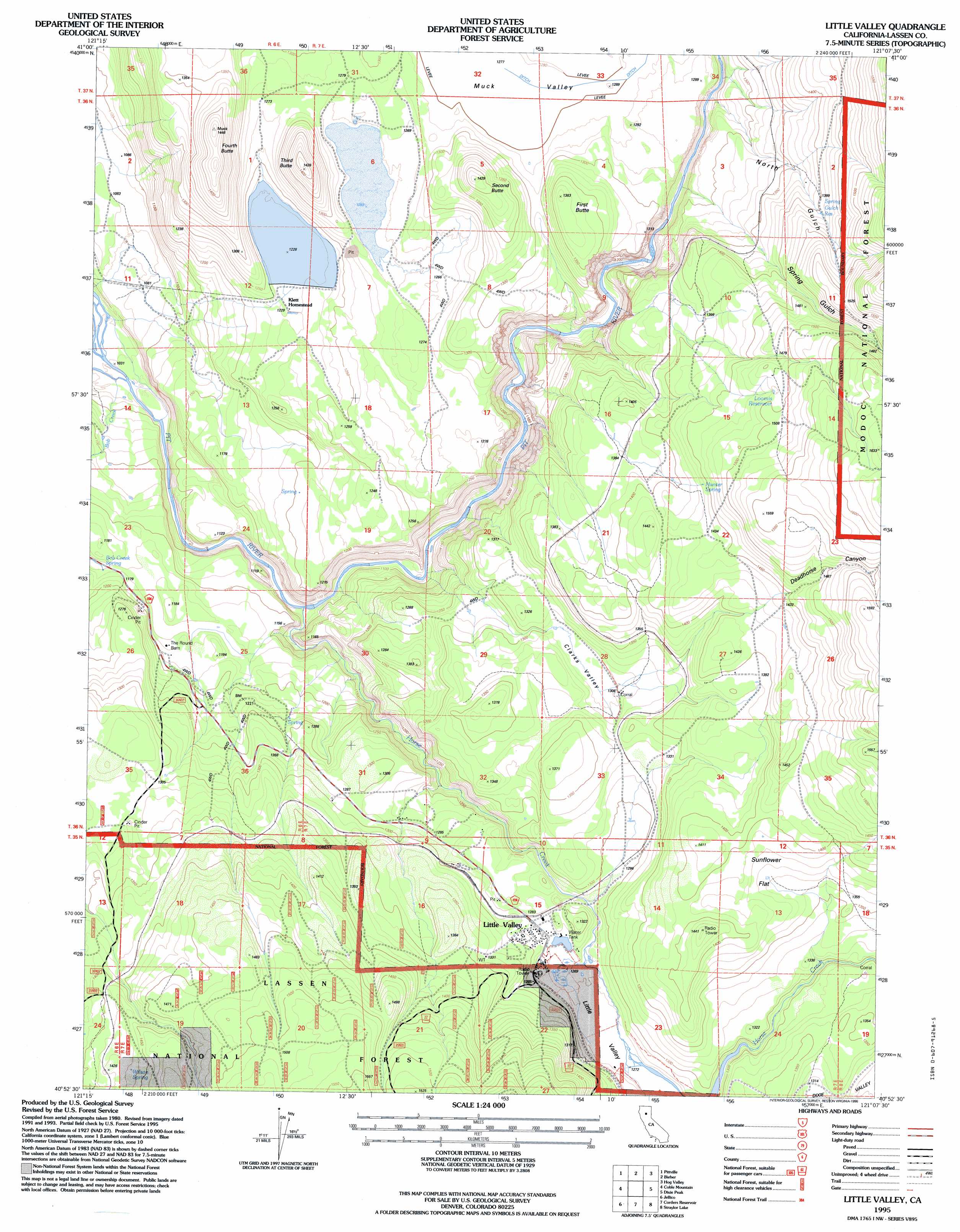
Little Valley Topo Map California
To zoom in, hover over the map of Little Valley
USGS Topo Quad 40121h2 - 1:24,000 scale
| Topo Map Name: | Little Valley |
| USGS Topo Quad ID: | 40121h2 |
| Print Size: | ca. 21 1/4" wide x 27" high |
| Southeast Coordinates: | 40.875° N latitude / 121.125° W longitude |
| Map Center Coordinates: | 40.9375° N latitude / 121.1875° W longitude |
| U.S. State: | CA |
| Filename: | o40121h2.jpg |
| Download Map JPG Image: | Little Valley topo map 1:24,000 scale |
| Map Type: | Topographic |
| Topo Series: | 7.5´ |
| Map Scale: | 1:24,000 |
| Source of Map Images: | United States Geological Survey (USGS) |
| Alternate Map Versions: |
Little Valley CA 1983, updated 1983 Download PDF Buy paper map Little Valley CA 1995, updated 1998 Download PDF Buy paper map Little Valley CA 2012 Download PDF Buy paper map Little Valley CA 2015 Download PDF Buy paper map |
| FStopo: | US Forest Service topo Little Valley is available: Download FStopo PDF Download FStopo TIF |
1:24,000 Topo Quads surrounding Little Valley
Timbered Crater |
Day |
Lookout |
Big Swamp |
Adin |
Fall River Mills |
Pittville |
Bieber |
Hog Valley |
Letterbox Hill |
Hogback Ridge |
Coble Mountain |
Little Valley |
Dixie Peak |
Silva Flat Reservoir |
Murken Bench |
Jellico |
Corders Reservoir |
Straylor Lake |
Bullard Lake |
Old Station |
Swains Hole |
Poison Lake |
Harvey Mountain |
Champs Flat |
> Back to 40121e1 at 1:100,000 scale
> Back to 40120a1 at 1:250,000 scale
> Back to U.S. Topo Maps home
Little Valley topo map: Gazetteer
Little Valley: Flats
Sunflower Flat elevation 1390m 4560′Little Valley: Populated Places
Dixie elevation 1382m 4534′Little Valley elevation 1277m 4189′
Little Valley: Reservoirs
Loomis Reservoir elevation 1491m 4891′Spring Gulch Reservoir elevation 1403m 4603′
Little Valley: Springs
Bob Creek Spring elevation 1159m 3802′Hunter Spring elevation 1421m 4662′
Wilson Spring elevation 1434m 4704′
Little Valley: Streams
Horse Creek elevation 1070m 3510′Little Valley: Summits
First Butte elevation 1382m 4534′Fourth Butte elevation 1440m 4724′
Second Butte elevation 1414m 4639′
Third Butte elevation 1401m 4596′
Little Valley: Valleys
Blacks Gulch elevation 1404m 4606′Clark Valley elevation 1298m 4258′
Clarks Valley elevation 1314m 4311′
Deadhorse Canyon elevation 1464m 4803′
Little Valley elevation 1270m 4166′
North Gulch elevation 1261m 4137′
Spring Gulch elevation 1287m 4222′
Little Valley digital topo map on disk
Buy this Little Valley topo map showing relief, roads, GPS coordinates and other geographical features, as a high-resolution digital map file on DVD: